Lots of people were queried in the 2050 Plan. Some had vested interests. Some knew nothing about the subject.
A lot of people would consider restoration their first choice. Restoration was not included among the choices in the 2050 plan. We hear plenty about environmental stewardship, compliance and sustainability. We rarely see the term restoration and only out of context. The 2050 plan feeds into this process coming and going.
The most important feature in any watershed, for those that have one, is its estuary. East Bay is the estuary of Moxlie Creek, one of the largest watersheds in the city of Olympia. At its lower end the stream runs through a long culvert into a body of water that’s been dredged, filled and armored with rock.
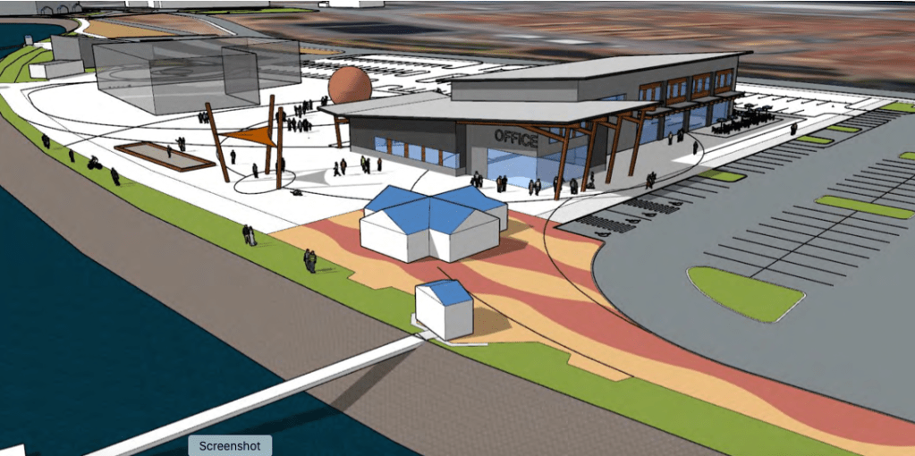
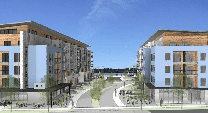
The Port of Olympia is launching a development plan for the shore of East Bay on the east side of the Port Peninsula. To the southeast will be administrative offices. Moving north will come mixed use, parking, restaurants and retail space. Buildings can be as close as 30 feet from the water’s edge.
The above graphic from the Port’s website represents an early rendition of the Marine Center design which was later enlarged to three stories and later to three buildings. To the south development is already underway.
In 2012 The Hands On Children’s Museum (HOCM) moved to its current East Bay location on historic fill. A building in this location should have never been allowed. What’s done is done. Land around the current structure could still be cleaned up, restored and enhanced.
In a big surprise, the Port sold the land (fill) on which the HOCM is located to the City. Current plans are to expand the building to twice its current size. The City is on track to issue bonds totaling $25,000,000.
Questions of contamination remain, water quality will be effected and the restoration option becomes greatly limited. This being a terrible location for such a huge structure comes as no surprise. The 1991 Budd Inlet Urban Bay Action Program is a comprehensive document. Following are excerpts of communications from federal agencies (USACE and the EPA):
“Planning for the future development of the urban waterfront should include enhancement of water quality and aquatic habitat as key elements. Future plans for the overall development of the waterfront should provide for protection and enhancement of water quality and aquatic habitat.”
“A related concern is that of Clean Water Act Section 404 fills in East Bay. Accordingly, fill material on the southeast portion of the Port peninsula (location of the HOCM) was only to be developed for water dependent uses.”
“Regarding your question on the use of Water Resources Development Act (WRDA) funding, the Service in 1990 recommended to the Corps that funding be provided to mitigate for fish and wildlife impacts caused by the construction of East Bay Marina Project. One of the options that was discussed involved measures to improve in-water habitat within the East Bay of Budd Inlet.” (not to be)
“Your inquiry about the appropriateness of using former intertidal areas that were filled for non-water dependent purposes raises some interesting questions. Such proposals are inconsistent with the Corps’ policy (EP 1165-2-1). Since impacts to fish and wildlife resources resulting from the project have already occurred, the Service is now primarily concerned with preventing further losses… Such areas should be reserved for bona fide Port purposes, instead of being used for non-water dependent facilities (e.g., Olympic Academy, restaurants, etc.).”
The sampling in East Bay indicates that there’s an area of dioxin and PCB contamination adjoining the HOCM (red dot on above aerials). The next step in the process is going to be to determine the nature and extent of the contamination. There’s a good chance the adjoining land in question is the source. In situations like this anyone who has ever owned, rented or done business on a contaminated parcel becomes a partly or potentially liable or responsible party (PLP or PRP). Teams of lawyers sit around a big table figuring out who owes what. Buying the land gives the City a seat at the table.
The museum is embarking on a $35 million fundraising campaign, $25 million of which will be secured by Public Facility District (PFD) funds wherein sales tax revenue is retained within a jurisdiction and used to promote tourism.
East Bay has the poorest water quality in Budd Inlet. The best and perhaps only way to restore chemical parameters like dissolved oxygen is going to be to restore some physical parameters, especially salt marsh and tide flats. Yet somehow whenever the subject of East Bay comes up, restoration is NEVER mentioned. It’s all about what we can get away with.
Under section 1191 the Action Plan Goal is to work cooperatively with all involved parties. “Voluntary commitment to perform the actions set forth in the action plan is the most efficient and cost-effective approach to addressing point and non-point contaminant sources in Budd Inlet. Successful implementation of the action plan will require the cooperation of all parties within the Budd Inlet watershed. City and county agencies responsible for source control and remedial activities include the City and Port of Olympia. The Budd Inlet ecosystem is being stressed and uses in the inlet are restricted because of low oxygen levels and bacterial and chemical contamination.”
Given funding shortfalls federal and state agencies are largely relying on local jurisdictions to see that laws are followed. Local jurisdictions seem to rarely understand or appreciate this. Federal agencies may as well be talking to the wind.
Chemical impairment
East Bay was placed on the 1998 303(d) impaired water list for PCBs based on samples of mussel tissue. Dioxin levels in sediments are high throughout the bay, in some locations exceeding thresholds by three orders of magnitude. These are some of the most biologically damaging chemicals known, being linked to cancer, birth defects and diabetes. Inner Budd Inlet has 95 chemical listings on Washington’s 303(d) list. (2)
An extensive sediment characterization was completed in 2008. The next step in the process was to identify the sources of contamination in Budd Inlet and control these sources, particularly those of persistent bio-accumulative forever chemicals including PCBs and dioxin. In the fifteen years since there has been no effort at source identification or control. Every priority is development driven.
Lost Ecological Function
Dredging, armoring and filling of East Bay has dramatically impacted species composition from plankton on up. The Port’s Destination Waterfront Vision plan suggests four improvements for East Bay which add up to the planting of 8000 linear feet of “functional riparian zone.” Allowed building setbacks are 30 feet from the high water mark. In marine nearshore environments where beaches are fringed with riparian vegetation, the upper intertidal wrack zone accumulates organic debris from algae. Seagrass and terrestrial plants provide food and shelter for many organisms. Armored beaches have substantially less organic matter and ecological connectivity. A narrow riparian planting will do little, especially if placed on top of a pile of rock.
Not a Random Sample
The task force includes the Port of Olympia Citizens Advisory Committee, South Thurston Economic Development Initiative (STEDI), Thurston Economic Development Council, Olympia Downtown Alliance, TRPC (elected officials from various jurisdictions) and the Thurston Chamber of Commerce. There are also representatives of schools, cities, tribes, and the public at large. Those with vested financial interests are going to be more likely to respond to and distribute questionnaires.
The Consultant Team for the Destination Waterfront Vision project contains six names. Two are from Thomas Architects, one is a Seattle architect specializing in nearshore developments, two are engineers and one is a contractor.
Conclusion
Even if data collected in the 2050 plan was a random sample, plans pertaining to this area should not be a popularity contest, they should be a science based course of action for reversing the damage we’ve done to a critical environment. Water quality in Budd Inlet could hardly get any worse and the worst water quality in Budd Inlet is in East Bay, along the eastern side of the Port Peninsula.
Federal law requires that when we have such poor conditions, restoration should at least be a component of any planning. State law, under WAC I73-26-201(2)(a) states that local governments should be prepared to identify three things: the scientific information and management recommendations on which the Master Program provisions are based; assumptions made concerning and data gaps in the scientific information; and risks to ecological functions associated with Master Program provisions through the process identified in WAC 113-26-201(3Xd)]….”when determining allowable uses and resolving use conflicts on shorelines”, local governments must apply the following preferences and priorities in the order listed below: Number one (i) Protect and restore ecological functions…”
Local restoration efforts can only be initiated at a local level. State and Federal agencies will not take the first step. Sadly, local jurisdictions governing Budd Inlet have no interest in restoration, which is unfortunate because restoration opportunities abound. The scale of this development along the shoreline will impede ecological function, reduce opportunities for cleanup of legacy contamination and eliminate restoration potential.
On February 27th the following letter was sent to the City Council and Port Commission:
West Bay Yards Shoreline Permit under review by the City of Olympia. Location at 1201 West Bay Drive. File number 21-2845.
This project would set a precedent. It would be difficult to allow such a development along the waterfront and deny neighbors the same. The most immediate concern would be the proposed West Bayview Landing immediately to the north. Impacts of West Bay Yards could be doubled.
The existing site is built on fill that years ago was placed behind a stone riprap wall about 300 feet out from the previous shore. The plan is to knock back the top few feet of riprap and add 35,000 cubic yards of fill up against what’s left out to the high tide mark. Another 26,515 cubic yards will be added below the high water mark for a total of 61,515 cubic yards of fill. This fill would bury whatever is there.
Fill doesn’t come with a ready made benthic community. Species composition evolves over time. Larvae, the swimming babies, swim in and adults move across the seabed, both of which occur slowly over time. Puget Sound’s benthos includes over 1,800 species of invertebrates living in or on the bottom sediments including ghost shrimp, worms, clams, crabs, and sea stars which are consumed by fish, birds, and marine mammals. These species choose specific places according to sediment composition. Soils in river and stream deltas are notoriously soft and muddy.
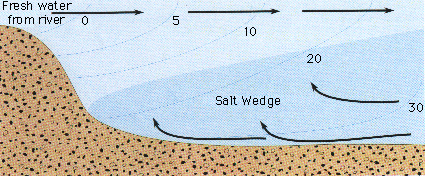
The delta of Schneider Creek is visible a few hundred feet north of the site in aerial photos. This location has been for thousands of years part or the Deschutes River estuary. The salt wedge is often visible a half mile to the north. If the stream wasn’t run through a pipe, its delta would probably come up to the project line. Companion streams often form an integral part of the structure of a river estuary. This development would limit larger options.
The response states that shoreline restoration and planting will improve foraging habitat for birds. An explanation as to how would be helpful. The plan states that “Shoreline restoration is a major component of this project”. To restore something means to return it to its original condition, place or position. Environmentally this would be the historic baseline. Nothing about this plan is anywhere near the historic baseline.
True beach restoration entails bulkhead removal. It does not involve piling material in front of bulkheads. Narrowing West Budd Inlet might increase velocity of waters flowing from the river and tides flowing in and out which combined with the steeper bank would increase erosion. Added to riverine sediments these will tend to find the lowest spots i.e. the shipping berths and channels.
There may be a solution. Use gravel as fill and call it a restoration. This would allow the growing of Pacific or Japanese oysters which would otherwise sink in soft mud, a possibility that is being touted as a benefit. These are not native species. They have no place in the ecosystem. The loss of species in Budd Inlet has been well documented. These may be birds who in some cases spend the winters here or are migrating through. It may be salmon and other fish all of whom depend on natural conditions.
Not that long ago Budd Inlet was a rich productive ecosystem providing habitat for numerous resident and migratory species, some listed as endangered and some locally extinct. What is the current richness and abundance of species that would be buried? How might this impact other species such as diving ducks? Any development of this scale in this location should be based on science.
The City’s Shoreline Master Program states that the City recognizes the importance of restoration of shoreline ecological function and encourages cooperative restoration efforts and programs between local, state, and federal public agencies, tribes, non-profit organizations and landowners…restoration actions should be targeted towards meeting the needs of both sensitive and locally important plant, fish and wildlife species…restoration should be coordinated with other natural resource management efforts and plans… restoration actions should consider system-wide benefits… restoration should give highest priority to measures that have the greatest chance of re-establishing shoreline ecological functions and processes… restoration and enhancement measures should be incorporated into the design and construction of new uses… shoreline restoration and enhancement should be considered as an alternative to structural stabilization… shoreline restoration and enhancement projects should protect the integrity of adjacent natural resources including aquatic habitats and water quality… restoration and enhancement projects should be in keeping with the SMP and restoration and enhancement projects should be designed to minimize maintenance over time.
The plan fails on all counts. There is no recognition of ecological function, no effort to meet the needs of sensitive and locally important plant, fish and wildlife species, no assessment of cumulative impacts or system wide benefits. And this is not a cooperative effort. It’s a matter of coming up with a plan and trying to sell it.
Whatever happens here will set a precedent, the objective being a waterfront surrounded by five story buildings and gravel fill. If scientific inquiry or existing rules play a role, it won’t happen.
There were no replies.
Footnotes…
(1) Environmental concerns are addressed in the 2050 plan in several sections. When asked their first thoughts on the Port 59 people responded environmental concerns. These were divided into two categories: Pollution, Environmental Concerns, Dirty Water and Sea Level Rise (40) and Environment, Stewardship, remediation and Capitol Lake (19). When asked where the Port should focus investment, 256 responded the environment. These included environmental stewardship (171), clean water/waterway health, sustainable salmon and water habitat (62), climate change and sea level rise (13) and the preservation of natural lands (10). When asked what we would like to see in the Port’s future the responses were environment, sustainability (247), stewardship, sustainability and green practices (153), clean water (62), removal of the Capitol Lake dam (20) and sea level rise (12)
(2) Parameters listed as impaired for inner Budd Inlet are dissolved oxygen,bacteria, 2,3,7,8-TCDD (dioxin), anthracene, arsenic, benzo(a)anthracene, benzo(a)pyrene, benzo(b)fluoranthene, benzo(k)fluoranthene, chrysene, dibenzo(a,h)anthracene, indeno(l,2,3-c,d)pyrene, polychlorinated biphenyls (PCBs), bis(2-Ethylhexyl)phthalate, cadmium, chromium, copper, fluoranthene, fluorene, lead, mercury, high molecular weight Polycyclic Aromatic Hydrocarbons (HPAH), pyrene, silver, zinc, low molecular Weight Polycyclic Aromatic Hydrocarbons (LPAH), 2-methylnaphthalene, 4-methylphenol, acenaphthene, acenaphthylene, benzo(g,h,i)perylene, benzoic Acid, dibenzofuran, naphthalene, phenanthrene, 1,2-dichlorobenzene,di-n-butyl phthalate, pentachlorophenol, phenol, benzofluoranthenes, total (b+k+j), butyl benzyl phthalate, di-n-octyl phthalate, and sediment bioassay. Parameters listed for outer Budd Inlet are dissolved oxygen, bacteria, benzo(a)anthracene, benzo(a)pyrene, benzo(b)fluoranthene, benzo(k)fluoranthene,chrysene, polychlorinatedbiphenyls (PCBs), 2,3,7,8-TCDD (dioxin), and benzoic acid. Parameters listed for inner Budd Inlet Category 4B segments are 2,4-dimethylphenol, 2- methylphenol, 4-methylphenol, pentachlorophenol, cadmium, chromium, copper, lead, phenol, zinc, sediment bioassay, anthracene, benzo(a)pyrene, chrysene, fluoranthene, fluorene, high molecular weight Polycyclic Aromatic Hydrocarbons (HPAH), pyrene, benzo(a)anthracene, low molecular Weight Polycyclic Aromatic Hydrocarbons (LPAH), 2-methylnaphthalene, acenaphthene, acenaphthylene, dibenzofuran, naphthalene, and phenanthrene.

 esolute spent a few years under a shed in the maintenance yard at Evergreen having some frames and decking replaced. For the first time an engine was installed, a 30 horsepower Perkins. The work was supervised by Don Fassett, a cantankerous, retired naval engineer and machinist. Don was full of truisms like “don’t hit it harder get a bigger hammer” or “a little putty and little paint will make the old girl what she ain’t” or more succinctly “it says here” which could serve as justification for anything under the sun. The original Kilroy, Don could fix an aircraft carrier at sea.
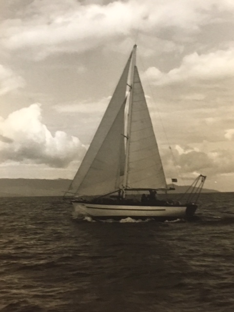
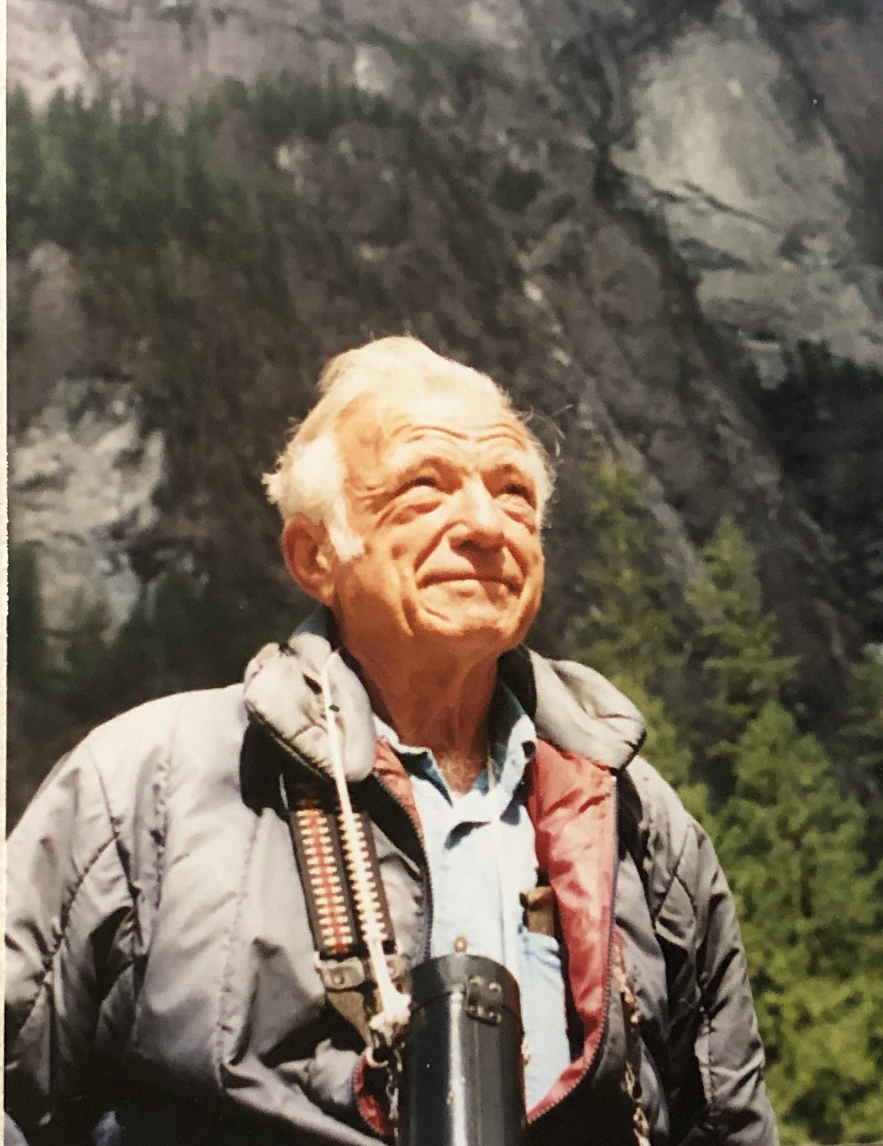 Don also owned a 40 foot William Garden designed sloop named Swirl II that he added to the fleet. Swirl II was not certified for commercial use so the number of paying passengers was limited to six