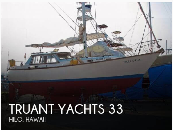
June 8th, 1986. 10 o’clock PM. Strait of Juan de Fuca, the vast Pacific Ocean ahead. Thalassa, a Truant 33 designed by William Garden, has all the attributes of a good sea boat — tall bow with plenty of flare, rounded midsections, modified full keel and canoe stern. The wheelhouse is a potential weakness but the windows have been reinforced. At 33 feet overall Thalassa is not a large boat. She’s light-footed in the gentle waves.
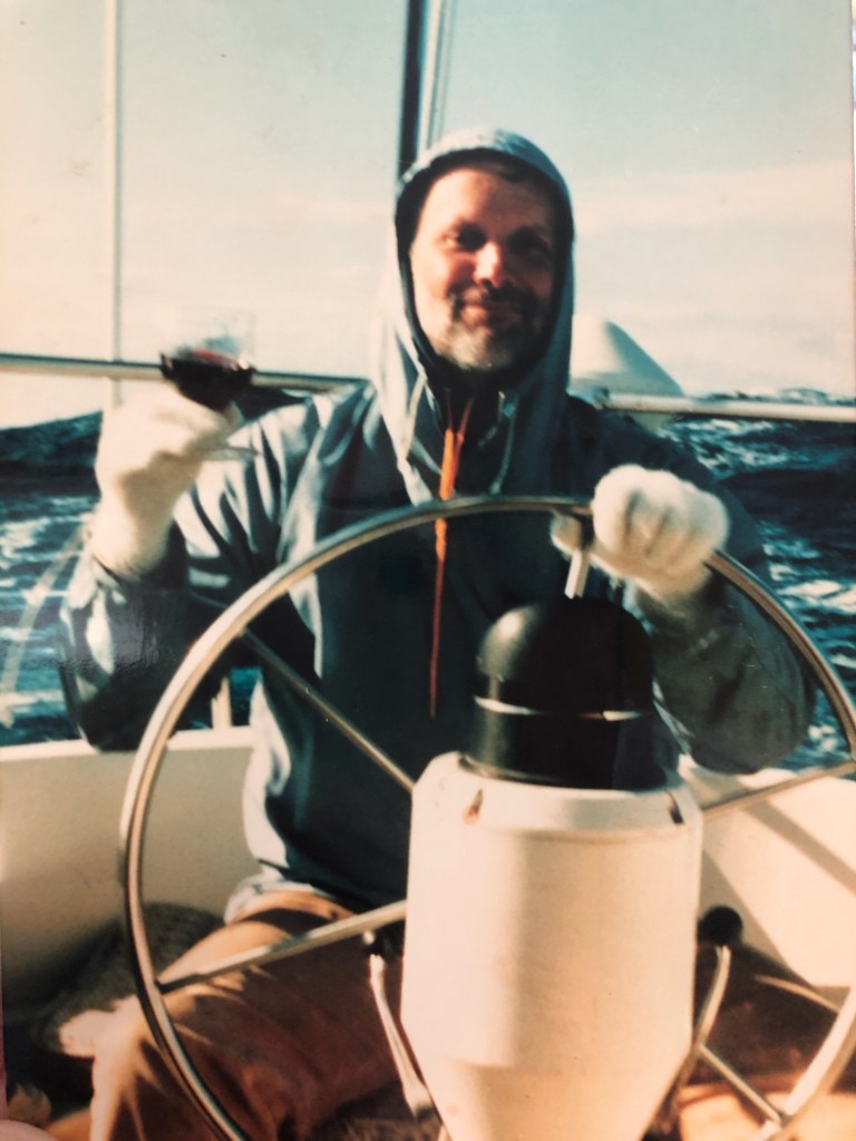
As we passed Tatoosh Island, we steered a course to the southwest, gradually gaining distance from shore. Don Davidson and myself, both licensed captains, would sail with a local physician named Chris King to San Francisco Bay. Chris owned the boat and knew every inch of it. We were all life-long sailors.
At 2 AM a dim light appeared on the horizon and immediately became the brightest object any of us had seen afloat. A second fuzzy light appeared behind the first and also grew in intensity. As they approached the objects turned into thousands of smaller lights, which slowly took the shape of ships, cruise ships. They passed close by, every deck and cabin light blazing.
We crossed the ships’ wakes continuing offshore to the southwest. The brightness of the departing lights made whatever was ahead complete darkness by contrast. The outline of the shore behind vanished in the mist.
The plan was to head southwest until we were 100 miles offshore, then head south paralleling the coast to central California and angle southeast to San Francisco Bay. This was chosen over option B, hugging the coast, ducking in and out of the most horrendous series of harbor entrances imaginable, in fog and all kinds of weather, while hopefully not getting blown onto the rocks. Going offshore would be more comfortable, or so we figured…
The wind gradually picked up out of the west. By dawn we were beating nicely on a starboard tack. Mid-morning the wind continued to build and came more from the northwest. We changed the roller furling genoa to a heavy duty 110% jib that could be furled smaller as need be. Sea kindly Thalassa threaded her way smoothly through waves as porpoises danced off the bow. We cheered them on, applauding spectacular jumps and stunts.
June 9th. The sky was clear, broken here and there by puffy white clouds. The ocean turned a deeper blue, the blue to which the term “blue water” refers, as opposed to the greenish blue closer to land. Sometimes the line between the two is clearly visible. We were 100 miles from shore, heading due south.
The wind was at our back. The seas were running about eight feet giving us a little push. It was the kind of day sailing is all about. But it was getting chilly and we realized none of us had brought any gloves. Chris managed to find a pair of white wool ladies dress gloves on-board that brought a smile. We cracked open a bottle of wine to toast our good fortune.
Late afternoon the wind picked up suddenly. Chris turned on the VHF radio. After several minutes of static a voice announced “Gale warning! The coast guard cutter (obscured) lying 200 miles off the Oregon Coast reports winds of forty knots, gusting to 55, and seas twenty feet and higher.”
The North Pacific is the biggest, widest body of water on earth. The bigger the water body the bigger the wave. We decided a sea anchor or drogue would hold us back increasing the likelihood that waves would break over the boat. Figuring that Thalassa’s wheelhouse and cabin doors might not stand up to being pounded by waves, we decided that our best chance would be to sail through whatever nature might bring our way. There was a small painting on the foreword bulkhead of Francis Chichester rounding Cape Horn in heavy seas flying only a small jib. It looked like a plan for which Thalassa was well suited. We dropped the mainsail and lashed it firmly to the boom.
By sunset the wind tore across wave tops spreading spindrift down their faces. We furled the jib to the size of a bed sheet. Thalassa’s hydraulic steering worked easily but steering was still tiring and we decided on one hour wheel watches. Turns at the wheel drifted into one another. One hour on, two hours off, turning the wheel from lock to lock, back onto a southerly compass heading, or toward Scorpius visible in the cloudless southern sky.
June 10th the wind and the waves continued to build. We reduced the jib to the size of a hand towel. Preparing for the midnight watch, layered up inside oilskins and a safety harness, I opened the companionway and from the cabin saw a shadow come up over the sky. The tiny boat battled its way backward up the wave. Near the top, the wave struck the stern giving Don a shower. I reached across the cockpit and latched the safety harness to the binnacle and stepped out. Standard practice. We didn’t want to lose anyone overboard.
There are basically two things that can go seriously wrong in a wave. I learned about them years prior. As a teenager I spent a couple of summers in Santa Cruz working in restaurants. My neighbor at the time was Mervyn Cadwallader, who went on to be one of the first deans at Evergreen State College. One day Mervyn invited me to go “big wave body surfing”.
We arrived at a place called Little Wind and Sea with our swim fins. Most waves in Santa Cruz break right. The waves here broke left and they were unusually steep. Mervyn estimated them at 16 feet. We swam out to where he said “This looks good”. A wave approached and he yelled “Swim” which I did. The wave broke on top of me, sending me for a loop. When I swam back out, Mervyn said “That’s what’s called getting sandwiched”. He then got us lined up again and when another wave approached yelled ”Swim” which I did. The wave grew in size and I found myself looking over a cliff. It broke throwing me down onto the water below. I was then drawn up into the wave and tumbled over and over. I made my way back to the surface in time to grab a breath of air and dive under the next wave.
At this point surfing has turned into skin diving. You hug the bottom and let the wave pass overhead. It’s why board surfers don’t surf Little Wind and Sea. There’s no beach, only rocks on all sides. The only way out is the way you came in. I got back to the surface in time to get a few breaths and dive under the next wave, followed by a few more. When I got back to Mervyn he explained “That’s what’s called going over the falls. You want to be somewhere between getting sandwiched and going over the falls. That’s all you need to know.”
As it turns out, there is more to know. The third wave I caught. Per Mervyn’s instructions I held my body strait and rigid like a board, turned toward the open shoulder of the wave and experienced one of life’s greatest thrills. Water rushing over your skin causes friction. Body surfing is a tactile, sensual experience. It became an obsession.
Sailors have different terms for getting sandwiched and going over the falls, the worst kind of wipeout, but the effect is the same. Waves may also push the stern to the left or right causing a broach. The boat may get knocked down on her side. All kinds of things can happen. But generally the drill is to keep the boat heading down the waves unless you find yourself preparing to jump off the top of a mountain in which case you turn away, heading across the top of the wave or over its backside, down into the next valley, wallowing in foam.
Waves as big as mountains dwarfed tiny Thalassa. She stood on her nose and surfed, pegging the knot meter at ten knots in a vertical dive. Sometimes the rushing water would come up close to the level of the foredeck but Thalassa’s tall sea bow always stayed above the rushing water. If the bow had gone under we were at risk of pitchpoling, where the boat rolls stern over bow.
Dining consisted of crawling or sliding the length of the cabin floor forward to the galley and cracking a cupboard door open and grabbing whatever flew out, perhaps a nutrition bar and a bottle of water. Using the toilet was a matter of wedging oneself into place and holding on.
How could we possibly survive? We were dodging bullet after bullet. Which one would have our name on it? I wondered, although it didn’t seem possible, if conditions might possibly get more intense and if so if any vessel of Thalassa’s dimensions would not be smashed to bits.
The wind pressed clothing against our bodies. Thalassa rolled far over to starboard, then hard over to port, standing on her nose speeding down a wave, or rolling on the summit looking out at mountains crawling across the landscape, or standing motionless in a valley looking up at an undulating approaching mass of water.
Although we were heading in a generally southerly direction, navigation per se was dictated by each wave. It was survival sailing. We had only the vaguest idea which direction we were heading or how far we’d come and didn’t really care.
By the storm’s third day exhaustion was complete. Sometime before dawn I passed the wheel to Chris and stumbled into the cabin, removed my rubber boots, vomited in one of them, collapsed in my bunk and lost consciousness.
June 12th. When I awoke, the cabin was bright with sunlight. Adding to my confusion, the engine was running. Outside, the waves were steep and menacing but smaller, perhaps twenty feet, of which perhaps the top couple of feet formed white caps, conditions that posed little threat.
I sat up and looked toward the cockpit. Nobody was there. The wheel turned back and forth, being driven by the auto pilot. I cleaned out my boots and put them on and stepped out. The boat was running directly downwind under power, flying the small jib. I let the jib out partway, took the helm and reduced the throttle.
After a while Chris emerged. “At dawn I was finished” he said. “I started the engine and turned on the autopilot”.
The satellite navigation system had not survived. Chris brought out a sextant and a stack of books. We tried working up sun sights but the bouncing and rolling of the boat made it impossible to come up with anything meaningful. But there were other, simpler options.
Before noon we started passing the sextant around, taking sites every minute or so for nearly an hour. We then threw out the outliers, the obvious errors, and were able to get an average for the sun’s highest point in the sky. Comparing this to declination in the nautical almanac for that day gave us a latitude fix.
Chris had also noted the moment of sunrise. Halfway between this and the moment of sunset would theoretically correspond to the zenith hour angle in the nautical almanac from which we could calculate longitude.
The morning of the 12th began with perfect sailing in rolling seas coming from the stern quarter. Mid morning a ship appeared off our bow. We raised them on the VHF and got a position. We were eight miles due west of where we thought they were. The noon sights for latitude had been exact. Timing sunrise and sunset to get longitude, not as exact but not bad.
Throughout the windstorm the sky had remained clear. By late morning a thin mist limited visibility to a mile or so. By noon we were immersed in heavy fog. We were then navigating by dead reckoning, following the compass and guessing our speed. We still had the depth sounder and the VHF radio though neither was at that time of any use.
Friday the 13th. We continued sailing through thick fog in a southeasterly direction, angling toward the California coastline. Every few minutes someone would check the depth. There was still nothing down there but water. But there was no certainty that the depth sounder was even functioning. To add to our anxiety we kept hearing what sounded like surf off our port side.
Something was surely out there in the fog. We sailed on listening and checking the depth sounder with less frequency as the day progressed. The night passed without incident and the morning of the 14th dawned again in thick fog. By late morning the fog was breaking here and there. We passed a small fishing boat, then another and several more.
Then Chris emerged from the cabin and announced “We have the bottom gentlemen.” Sure enough, a broken line appeared on the screen, eighty fathoms or about 500 feet down. We followed that contour for a while, then it grew shallower which we figured must be the edge of the San Francisco Bar, location of the Potato Patch Shoal. The water then grew deeper again to our relief. We followed depth contours curving around to the east, sailing toward land lying somewhere dead ahead. The readings continued to grow deeper. The Farallon Islands appeared astern. Point Bonita appeared off the port bow. The Golden Gate Bridge appeared overhead.
How big were the waves? Taller than Thalassa’s 45 foot tall mast. According to the Coast Pilot and Sailing Directions, the largest waves on earth, measured in the Eastern Pacific off the coast of North America, can measure over 100 feet.

Amazing story. I could hear your voice when I read it.
LikeLike