Introduction.
Budd Inlet lies in the shadow of the Capital of Washington State, in plane view of elected representatives and agencies assigned with protecting waters of the state. It is a symbol of state waters. If Budd Inlet is not protected, what waters will be? And yet Budd Inlet is a sickly remnant of a once vital ecosystem. Species that once proliferated are gone. The waters contain too much nitrogen and too little dissolved oxygen. Toxic chemicals flow from undetermined sources. Estuaries that would have been ideal candidates for restoration have been developed. Land that is unnatural fill has been protected and restored.
Management typically does not follow broadly accepted scientific protocols. As such, the science is incomplete and manipulated. The most applicable disciplines, ecology and oceanography, are never employed in land use decisions.
Ecology is a branch of biology pertaining to the interactions of plants and animals in the environment in which they live, recognizing that these interactions are complex and beyond our complete understanding. The goal of Ecosystem Based Management is to maintain an in-tact system where the mysteries of life can play out.
Oceanography is the study of the interactions of physical, chemical and biological parameters. Physical parameters would include shape, structure and circulation patterns. Chemical parameters would include dissolved oxygen and levels of nutrients including nitrates. Biological would include all species from plankton up to apex predators.
Ecosystem Based Management (EBM) seeks to incorporate the full array of interactions within an ecosystem rather than considering single species or issues in isolation. Research narrows the scope of study to be thorough. Managers manage specific concerns. There are few inherent tendencies or incentives to look beyond the immediate.
An Ecosystem Based Approach
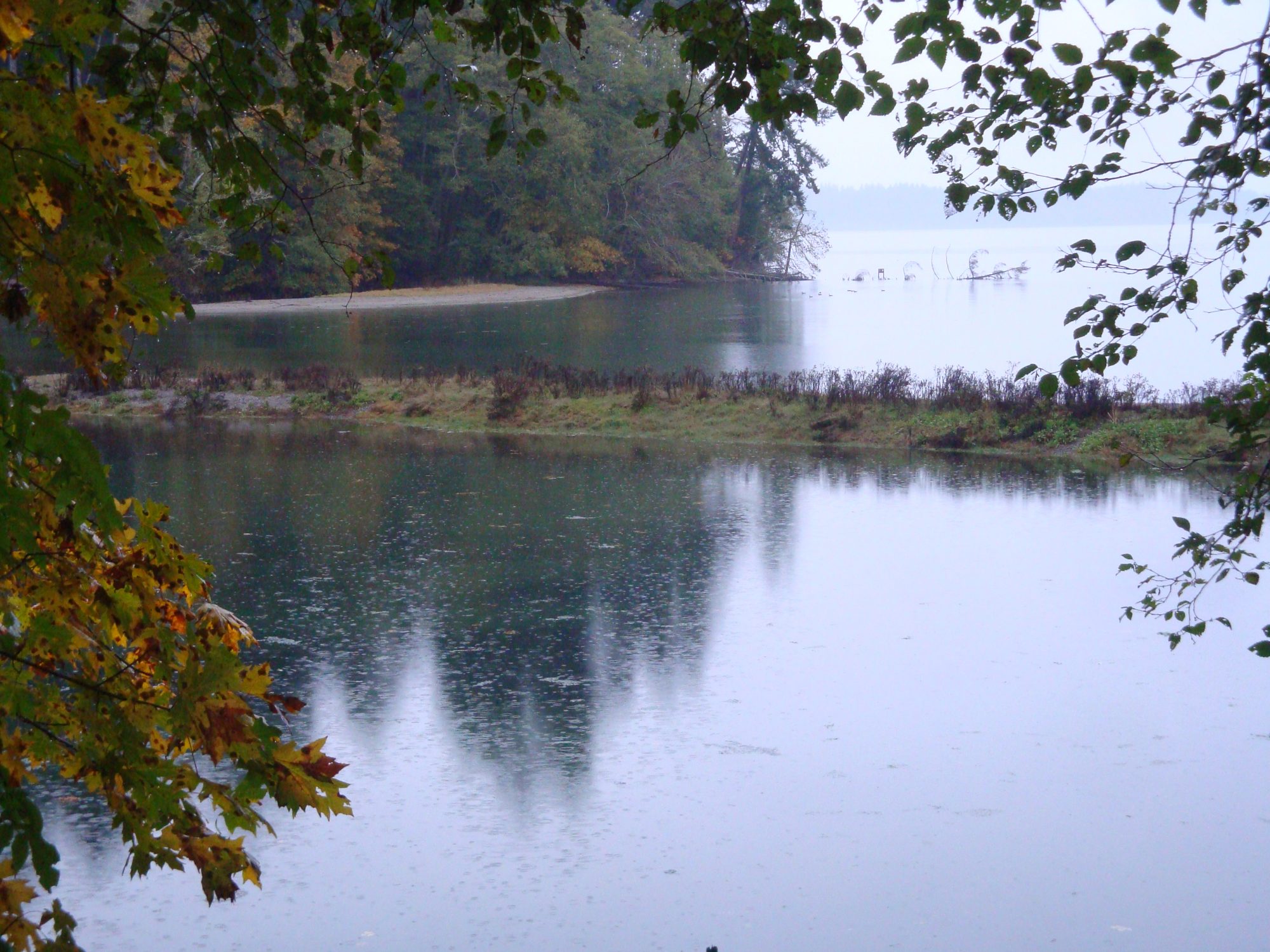
The Puget Lowland Ecoregion borders the shoreline of Puget Sound. Lowland watersheds tend to drain directly to the sound through many streams. What happens in these watersheds directly impacts Puget Sound. These watersheds are heavily urbanized. If we want to improve the health of Puget Sound we need to do a better job of managing lowland watersheds. We’ve in many cases unnecessarily blocked the hyporheic zone, the area of saturated soil on either side of and below a stream and the accompanying filtering actions of sand and gravel and interactions with biota. In Olympia, 160 miles of surface and near surface waters have been confined to culverts.
Each lowland stream that flows directly to the Sound has an estuary which together form a “string of pearls” for migrating salmon. Estuaries rank among the most productive ecosystems. Rivers and streams slow and broaden as they encounter seawater, expanding the photic zone, the area penetrated by sunlight, and increasing the time water takes to move through. Because of their position at the base of a watershed, estuaries have high nutrient concentrations. In a modified estuary phytoplankton blooms and die offs result in low levels of dissolved oxygen. In a natural estuary persistent mixing patterns move zooplankton up into the system where they can help control phytoplankton abundance.
Phytoplankton are the base of the food web on which all life depends. Phytoplankton generate atmospheric oxygen through photosynthesis and sequester carbon as they have for millions of years. They were among the earliest forms of life. They are the reason the earth looks like it does from space.
Modifications to physical parameters such as shape, structure and composition impact chemical parameters such as dissolved oxygen and biological parameters such as plankton. We cannot fix a damaged ecosystem without fixing physical parameters. The baseline should be the way things once were, not the way they are now. There’s plenty of ecology occurring in urban settings and lots of room for improvement.
Budd Inlet, A Case Study
Budd Inlet is the southernmost body of water in Puget Sound. Olympia, the State Capital, lies at its southern end. The Deschutes River, now impounded by a dam that forms Capitol Lake, flows into the bay, as do a number of streams. The Port of Olympia occupies a long peninsula that divides the bay into East and West portions.
East Bay, the estuary of Moxlie Creek, is a semi-enclosed water body on the eastern side of the Port Peninsula. Both East Bay and Moxlie Creek are classified as federally degraded waterbodies. There are too many nitrates and too little dissolved oxygen and the sediments are contaminated with dioxin, PCBs and other toxic chemicals.
Historically, the Cascade Pole wood treatment facility occupies the end of the peninsula. Dioxin laced creosote was spilled at the site. In 2001 a confined disposal site was constructed at the location for contaminated sediments dredged from the neighboring nearshore. A sheet pile and slurry wall surround the site. Neighboring soils on land were not included and contamination has since been found in these soils. Dioxin in surface sediments indicates probable ongoing uncontrolled sources.
Low levels of dissolved oxygen have also been documented in Budd Inlet. The problem is most propounded impacted. Oceanography is the analysis of physical, chemical and biological parameters. These are typically expressed in this order because physical parameters, such as strcuture and circulation, impact chemical parameters, such as dissolved oxygen and biological parameters, such as phytoplankton.
A stream in a pipe is unable to process nutrients because there is no sunlight and hence to plankton. Molxie Creek runs through a half mile long culvert before entering East Bay. The estuary of Schneider Creek across Budd Inlet on the western chore runs thought a 500 foot long culvert. Both culverts are intertidal, the tide backs up their entire lengths. In both cases, the most important part of any watershed, the estuary, is run through a pipe.
Estuaries are the place where fresh water and nutrients flowing from land encounter and mix with marine waters. Fresh water being lighter than salt water tends to flow out on the surface drawing salt water and marine organisms in underneath. Nutrients are consumed by phytoplankton, tiny plants in a process known as primary production, the origin of life Phytoplankton are in which are in turn consumed by zooplankton which either grow into larger fish or are consumed by larger fish which are then consumed by larger species and so on up the food web. Persistent mixing patterns, the result of natural structure best illustrated by tide flats are critical to the process. It all happens best in shallow waters in the presence of sunlight and atmospheric oxygen.
In Puget Sound, the most important physical parameters, the estuaries including those of streams, have been channeled through long culverts. They’ve been dredged for navigation and other human uses and their shores have been armored with concrete and rock to prevent erosion and provide for industry and development.
Indicator species such as apex predators tell us a lot about the health of an ecosystem. Waterbirds such as diving ducks a especially good indicators for a bay like Budd Inlet. On June 15, 2002 the City of Olympia was presented with the West Bay Habitat Assessment by R.W. Morse. R.W. Morse is the author of several popular field guides and considered a leading expert on Northwest Birds.
Although there were still many birds, the report states that the “biggest surprise of the study” was that the number and diversity of waterbirds had dropped significantly. A mere 15 years earlier 30 to 80 waterbirds would be seen per visit, just between the 4th and 5th ave. bridges. The R. W. Morse Assessment is comprehensive. Fifty six surveys were conducted over an eight month period. Along West Bay they counted 39 species of waterbirds and six raptors, for a total of 15,231 sightings. The authors suggest repeatedly that we should make some effort to find out why the birds were vanishing and have since vanished.
As of 2002 birds facing local extinction included: Red-necked, Horned and Western Grebes, Pelagic Cormorant, Surf Scoter, Barrows Goldeneye, Hooded, Common and Re-breasted Merganzers, Ruddy Duck, Bonaparte’s Gull and Mew and Red-winged gulls. Some were already considered locally extinct including: White Winged and Black Scoters, American Wigeon, Canvasback and Rhinoceros Auklet.
Today, the rate of outright extinction is six times higher than the average over the last 500 years. But this number doesn’t account for a much larger number of species whose status is deteriorating. We work to reduce those critically endangered species from going extinct while species at low risk move into higher-risk categories. The extinction risk in birds is accumulating much more rapidly than previously appreciated, (8)
Scoters were predicted to be locally extinct as of 2004, which turned out to be an accurate prediction. Populations Puget Sound-wide were falling more slowly. Populations fell more quickly here because there’s something particularly wrong here. It’s no mystery what’s wrong and what solutions wold look like. We a bay mitered with dioxin and PCBs two of the most biologically damaging chemicals known. We have too many nutrients and too little dissolved oxygen. We’ve lost primary production (healthy phytoplankton populations) and secondary production (healthy zooplankton populations) and spawning and rearing habitat (for forage fish). We know how to fix these things: Daylight streams. Clean up and restore estuaries. Bring back tide flats and salt marsh.
Citizen actions and responses from the Port and City of Olympia
On July 7th, 2015 Olympia Urban Waters League (OUWL) gave a six minute presentation before the Olympia City Council on the potential benefits of removing culverts in Moxlie and Indian Creeks. This began a two year process of lobbying city staff and council members on the feasibility and benefits, especially in the lower watershed including the waters of East Bay, the most degraded waters in Budd Inlet.
The Olympia City Planning Commission, made up of community volunteers, stated that Moxie Creek could not be daylighted because the culvert runs underneath buildings. Ouwl responded that the stream could follow any pathway as long as water flows downhill. The Design Review Board, also comprised of community volunteers, refused to allow public comments on the subject.
The City recognizes that spawning habitat could be improved in both streams through the addition of large organic debris and the removal of 22 upstream culverts but until long downstream is removed the potential will not become significant. In response to suggestions to daylight the downstream culvert the response is that until upstream conditions are improved potential is likewise limited. It’s not worth fixing A if we don’t fix B and it’s not worth fixing B if we don’t fix A so let’s fix neither. (8)
Development moves forward
In 2017 developer Walker John and architect Ron Thomas entered into a contract with the Port to build a large mixed use structure called Westman Mill at the head of East Bay, on top of fill in the exact center of the historic estuary of Moxlie Creek. The City issued a State Environmental Policy Act (SEPA) determination of non-significance (DNS), meaning among other things that an Environmental Impact Statement (EIS) was unnecessary. OUWL, feeling that an EIS should have been required, appealed the plan. The group felt that by not considering contamination source control and restoration, the plan was in violation of numerous acts and laws. They hired a team of attorneys and paid the City $1000 to appeal.
The City, the Port and the Developer didn’t want to prepare an EIS. They formed an alliance and assembled a legal team. Dale Kamerrer and Jeff Meyers of Law, Lyman, Daniel, Kamerrer, Bogdanovich, P.S. represented the City. Heather Burgess of Phillis Burgess PLLC represented the Port. Joseph of Rehberger Cascade Law Group PLLC represented 3rd Generation Development.
Hearing Examiner Mark C. Scheibmeir rendered a decision on May 3rd. He declared that according to City Code a stream in a culvert is “not a stream” and that the appeal as such was a collateral attack on a city ordinance; that arguments that the development would limit future restoration of Eastbay and Moxlie Creek are “speculative” and “do not constitute an adverse environmental impact”; and most significantly that OUWL failed to demonstrate “evidence of specific and perceptible harm” to themselves or their property, that is, they lacked standing.
OUWL felt that city ordinances do not supercede the Endangered Species and Clean Water Acts, that some members of OUWL do have standing where marine waters are concerned and given that the tide backs up the entire length of the Moxlie Creek culvert, it is intertidal, brackish marine waters and OUWL should have had standing. In order to make these arguments OUWL would have had to have standing and without standing they could not make the arguments.
OUWL appealed the decision to Superior Court. The Port/City/Developer legal team responded with an Affidavit of Prejudice to Disqualify Judge James Dixon who they felt wouldn’t be fair and objective. Judge Christine Schaller was appointed who in a swift decision reaffirmed the Hearing Eaminer’s decision.
The Moxlie Creek culvert lies 200 feet east of the Westman Mill development in the exact center of the historic estuary of the stream. Being historic fill, deep pilings were driven. Retail space is provided on the ground floor, eighty five market rate housing units above. The scale of the building, the pilings and other features mean that the historic course of the estuary can now never be recovered. (1870 drawing of Budd Inlet with star on Westman Mill locations)
We’ve lost over 160 acres of tide flats, sea grass and salt marsh to fill in the historic Moxlie Creek estuary. We had an opportunity to get four of them back. We had an opportunity to restore intertidal areas in the Moxlie creek estuary. Instead we got the Westman Mill development.
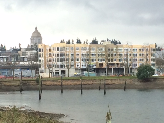
Westman Mill Development
Capitol Lake:
Capitol Lake was created in 1951 by the construction of a dam. Beginning in 2001 Friends of Deschutes began advocating gof rte removal of the dam. A protracted debate ensued. In 2009 Friends of Deschutes disbanded and the Deschutes Estuary Restoration Team was created. A counter group, the Capitol Lake Improvement and Protection Association formed to counter the effort. The State formed the Capitol Lake Adaptive Management Plan to manage a seemingly endless series of meetings that continue to this date.
Somewhere between half and two thirds of the historic estuary currently lies outside and north of the dam in an area dominated by the Port Peninsula and East Bay. Getting rid of the dam would not equate to restoring the estuary. East Bay, the estuary of Moxlie Creek was a dominant feature in the estuary. Many rivers have a companion stream that helps shape and form the estuary. Examples include Hylebos Creek for the Puyallup River, Medicine Creek for the Nisqually River. Somehow, Moxlie Creek and East Bay have escaped the discussion.
Much of the debate focuses on salmon habitat which is ironic. There was no native anadromous (seagoing) salmon run in the Deschutes River because of Deschutes Falls. We have constructed a series of fish ladders and established hatcheries above the falls so there is now a limited hatchery run. By contrast both Indian and Moxlie Creek have historically supported limited numbers of anadromous fish. Chum, sea-run cutthroat, coho, chinook, and steelhead all migrated to Indian Creek. In recent years, salmon of unknown species have been observed in Indian Creek immediately upstream of the confluence with Moxlie Creek and coho, chinook, and steelhead spawn in Moxlie Creek, primarily in the upstream creek segments within Watershed Park. Information on the population status and trends of resident fish in Moxlie Creek is not available. (7)
The Salmon Recovery Funding Board gives grants “for purchases and projects aimed at supporting endangered salmon”. In 2019 Capitol Land Trust was awarded $471,832 to buy 220 acres along the Deschutes River and Silver Creek to conserve chinook, coho and steelhead habitat. South Puget Sound Salmon Enhancement Group got $183,187 to install wood structures in the Deschutes River that serve as a place for fish to rest and feed and also slow down the river to reduce erosion. The problem is there are no endangered wild salmon stocks in the Deschutes River because of the falls. There were and may still be wild stocks in Percival, Moxlie, Indian, Ellis and Schneider Creeks. It would make better sense to invest that $655,000 in culvert removal, if our true interest is supporting endangered salmon populations.
Why would we invest endangered salmon restoration funds to enhance hatchery fish? Hatcheries are inherently not ecosystem based. Their structure is artificial. Some portion of natural selection is taken out of the equation. They can compete with native fish and pollute their genetics.
South Budd Inlet probably never supported the numbers of salmon that we find in river estuaries that aren’t blocked by a waterfall. Although little data exists, anecdotal accounts indicate that South Budd Inlet once supported enormous populations of herring, sand lance and surf smelt. These forage fish provided important food for salmon migrating through.
Ongoing sources of dioxin
A Sediment Characterization for Budd Inlet completed in 2008 was to serve as a guide to identifying sources of ongoing contamination. After sampling the entire bay for hot spots we were going to seek out their sources and clean them up. Once the sources were controlled development could proceed.
The City has chosen to reverse the process and base cleanup on development priorities. In 1980 over a million cubic yards of contaminated dredge spoils were used as fill somewhere on the Port Peninsula. The highest levels of dioxin contamination in Budd Inlet are found at the southern end of East Bay adjacent to a million cubic yards of fill underlying places being developed. Why was so much money spent on the Sediment Characterization if we’re going to ignore it?
The ubiquitous mischaracterized cleanup
Dioxin is a family of chemicals that are like PCBs built around a chlorine atom. They are among the most bilabially damaging chemicals known, having gained notoriety for Agent Orang in Vietnam, Love Canal New York and Times Beach Missouri. Dioxin in Budd Inlet is especially problematic because as a component of creosote it moves with ground water and tidal flow.
In 2001 contaminated sediments were removed from the area lying north of the Port Peninsula and placed in a containment cell at the previous location of the Cascade Pole company where logs had been treated with creosote over several previous decades. On the northern side toward the bay a steel sheet pile wall was installed. At the southern, landward side a slurry wall, a trench filled with liquid bentonite clay, was installed. Prior to 2001 over a million cubic yards of contaminated sediments were dredged and used as fill. The United States Army Corps of Engineers (USACE) who oversaw the dredge and fill operation has no idea where the fill was placed.
A few years later when installing utilities work was halted because holes in the ground were filling with oily substances. It was then determined that the log yard was also contaminated and the slurry wall was extended. According to Federal protocols slurry walls of this type should not be used in areas that are impacted by tidal flux which the log yard is twice each day. We also know that sheet pile walls have a limited life expectancy in salt water environments. So really nothing about this effort will be effective and long lasting.
There is a long list of cleanup activities that have been carried out in Budd Inlet. In reality and according to the proper definition of the word, very little has been cleaned up. Contaminated soils have been moved around and capped in place. A hot spot in the shore near the Westman Mill development contains dioxin in over 1100 parts per trillion (ppt). By contrast, the USACE threshold for open water disposal in Puget Sound is 3.5 ppt. The Port’s consultant claims that 1100 ppt is just a pile of old wood debris and not a concern, a claim that’s accepted by the Department of Ecology.
Two decades ago, a small environmental group reached a lawsuit settlement with the federal Environmental Protection Agency that launched a major new effort to tackle water pollution in Washington state.
Under the 1998 agreement, the state Department of Ecology had to develop cleanup plans for nearly 1,600 bodies of water, from the Puget Sound to the Palouse River that winds through the state’s wheat country, with the EPA overseeing work called for by the federal Clean Water Act.
The group — Northwest Environmental Advocates — as of 2019 is now back in U.S. District Court, alleging that federal and state officials have moved too slowly, and that they violated federal law by failing to get the plans done by a 2013 deadline.
“You’ve got a lot of foot-dragging. They push a lot of paper … but when it comes down to doing anything about pollution controls, they (Ecology) slow walk it,” said Nina Bell, executive director of Northwest Environmental Advocates. “And the EPA is unwilling to step in when the state fails. That is why we turn to the federal courts.”
A Better Way. Solutions.
A science based approach would begin with observation, much based on previous science. We observe that too much nitrogen, a nutrient for plants, can cause an overgrowth of phytoplankton. During the growth phase the phytoplankton produce lots of dissolved oxygen through photosynthesis. But then since they’ve overproduced they die and rot which gobbles up all the oxygen. The problem ultimately isn’t too much nitrogen it’s too little oxygen.
Then we form a hypothesis… low dissolved oxygen in Budd Inlet is the result of septic tank failures or LOTT or not the result of runoff from the Port, or whatever.
And the one that we’ll never advance. Low levels of dissolved oxygen in Budd Inlet are the result of Olympia’s having run 160 miles of surface water through culverts. The study below states that nitrates travel 18 times farther in buried pipes. A reasoned hypothesis would be that long culverts are a major source of low levels of dissolved oxygen.
The study of oceanography is taboo in this discussion. Oceanography is the tudy of physical (shape, structure, current). chemical (oxygen, nitrates) and biological (plankton) parameters. One proven way to improve chemical and biological conditions is to improve physical conditions. These lines are never connected.
There has been a failure to consider the effect of watersheds on marine water quality, asserting for example that there is no correlation between poor water quality in East Bay and poor water quality in Moxlie Creek which flows into East Bay. There has been a failure to meet standards for surface water runoff by asking for and receiving extension after extension on Port of Olympia log yard discharges. There has been a failure to control groundwater discharges, a failure to make any effort regarding ongoing uncontrolled sources of dioxin coming from historic fill. Definitions are important. A restoration should be a restoration. A cleanup should be a cleanup. Sustainable should be sustainable. Native salmon should be native salmon not hatchery salmon. Changing the definitions of words leads to confusion.
Phytoplankton account for half of all photosynthetic activity on Earth. Their cumulative fixation of carbon through primary production is the basis of oceanic food webs. There is virtually no primary production in East Bay because Moxlie Creek runs through a half-mile long pipe and empties into a dredged hole. Phytoplankton are the oldest and one of the biggest carbon sinks. They’re a major source of atmospheric oxygen.
Sea grass and salt marsh hold fifteen times the carbon per acre as Amazon rain forest. When coastal habitats are lost not only do they no longer capture carbon, carbon captured in the past is released. They turn from carbon sink to carbon emitter.
One of the tenets of science is the “baseline”, the starting point, that to which what comes later is compared. We use current conditions as a baseline the hope being to determine if things are getting better or worse. The true baseline lies much fatter back in time. What existed before we began inflicting damage on natural systems.
Another frequently battered term is “best available science”. Good science begins with observation. We then form a hypothesis, run a test or experiment and then arrive at a conclusion. If we don’t follow these steps science can be pointless, incomplete and manipulated.
Indigenous people have long followed scientific methodology. They observe, for example, that birds are circling, hypothesize that herring are being driven to the surface by a predator, test with a dip net and conclude that such is the case. The experiment is repeated to improve probability and refine the conclusion. This is not to claim that indigenous people have some kind of genetic or biological imperative to understand these things. They are contained in traditions which developed over thousands of years of practicing good science.
The Deschutes, was named Steh-chass River. The Steh-chass people lived in three large cedar plank homes, up to eight families in each. Another village, Bus-chut-hwud, “frequented by black bears”, was located near what is today Percival Landing. In what is today East Bay, a long estuary lead to another village and namesake stream, the Pe’tzlb. There were also villages in the estuaries of Percival, Schneider and Ellis Creeks.
Nisqually tribal historian Cecelia Svinth Carpenter in her book Fort Nisqually states that “Almost every freshwater outlet on Puget Sound” was”inhabited by one band of Indian people or another. The Sequalitchew band of the Nisqually Indian Tribe had lived in the sheltered cove at the mouth of Sequalitchew Creek since as far back as any Inidan person could remember. As the floor of Sequalitchew ravine edged itself down the hill to the lower elevations, if followed the bed of the stream. By the time both entered the area of the cove, they were just a bit above sea level and had settled down to form a relatively flat shelf before making a final descent to the salt water of Puget Sound. It was on this long, narrow shelf or cove, safely above the rise and fall of the tide, that the people of the Sequalitchew had long ago built their cedar homes. In those days there were between 40 and 50 people living in the village counting all the men, women and children, perhaps representing five or six extended family units.”
Ecosystem based management should begin with the true baseline, that which existed prior to our destroying it. We might learn to be caretakers not takers. We don’t own the water air and land. We should in all decisions consider the effect over seven generations, 200 years. We might learn what we can about how indigenous people sustained livelihood for thousands of years. First People recognized the importance of stream estuaries. Olympia doesn’t even recognize their existence.
The situation is not unique to Olympia. An 1800 page global assessment of nature has been compiled by the Intergovernmental Science-Policy Platform on Biodiversity and Ecosystem Services (IPBES). A 40-page “summary for policymakers”, published on May 5th, is a powerful indictment. Around a million species face extinction within decades. Only 13% of the earth’s wetlands present in 1700 still exist. Natural ecosystems have declined by 47%. The global biomass of wild mammals has fallen by 82%. (4)
Other studies indicate a $40% reduction in plankton world wide. Diatoms, the largest type of phytoplankton algae, have declined globally more than 1 percent per year between 1998 to 2012, with significant losses occurring in the North Pacific. Published in 2015 the findings were reiterated by three more studies on phytoplankton abundance, published in quick succession. According to National Geographic, The Living Planet Index score for freshwater populations of water dwelling animals has plummeted by 83 percent. A report from the World Wildlife Fund affirms a nearly 50% decline in marine life populations between 1970 and 2012.
Conclusion
The City and the Port are public entities. The costs of employing the legal team they assembled to defeat opponents of the Westman Mill development were substantial. The members of OUWL also paid for legal council in addition to paying the City $1000 for the right to file the appeal. A United Nations IPBES report states that governments must end the “destructive subsidies” that “drive the plundering of the land and ocean at the expense of a clean, healthy and diverse environment on which billions of women, children and men depend”. It calls for a “transformative change”, steering the world away from the “limited paradigm of economic growth”.
Our laws are representative of our ways of thinking. Often our way of thinking is also formed by our laws. When slavery was banned it took little time for the idea to be found unacceptable, even to the most ardent racists. It simply was no longer in our mindset. There are two movements afoot in this direction:
The Rights of Nature is the recognition that ecosystems and all their components have rights just as human beings have rights. Rather than treating nature as property under the law, we acknowledge that nature in all its life forms has the right to exist, persist, maintain and regenerate its vital cycles. And we, the people, have the legal authority and responsibility to enforce these rights on behalf of ecosystems. The ecosystem itself can be named as the injured party, with its own legal standing in cases alleging rights violations. Governing bodies like the City and Port of Olympia would no longer be able to dodge appeals based on merit by denying standing. (5)
It has been suggested that ecocide, the willful destruction of ecological systems, be made a crime under international law at the very highest level, somewhat akin to genocide. Although such movement by the United Nations may be a long time coming, there’s no reason it couldn’t happen at a state level. If an individual or group of individuals falsify or ignore plainly presented information and degrade natural systems and species in the process, they could be found in violation of the law and be subject to prison sentences. (6)
If we want to reverse the damage done to Puget Sound we should allow science into the process. We should form hypotheses based on observation and follow accepted protocols to test these hypotheses. We should explore oceanographic parameters. How are modifications to structure impacting water quality and species richness?
And ultimately we must accept ecological grief. There’s a power and honor in grief. It means we’ve loved something. We’ve had a connection to a place and its species. We need new rituals to celebrate that love… to mark and share the loss.
Bibliography
(8) Olympia Woodland Trail Feasibility Study dec 1998 containing Caldwell and Associates 1996, fish habitat investigation Indian Creek prepared for Olympia Parks
(1) West Bay Habitat Assessment Final Report
June 15, 2002
RW Morse Company
(2) Urban Stream Burial Increases Watershed-Scale Nitrate Export
Journal Pone, July 17, 2015 Jake J. Beaulieu et al
https://www.ncbi.nlm.nih.gov/pmc/articles/PMC4505844/
(3) https://www.youtube.com/watch?v=7_Q-0xj7-dk
(4) Summary for policymakers of the global assessment report on biodiversity and ecosystem services of the Intergovernmental Science-Policy Platform on Biodiversity and Ecosystem Services. Sandra Díaz et al. May 2019
https://ipbes.net/system/tdf/ipbes_7_10_add.1_en_1.pdf?file=1&type=node&id=35329
(5) https://therightsofnature.org/what-is-rights-of-nature/
(6) https://ecocidelaw.com/the-law/existing-ecocide-laws/
(7) (Appendix D: Summary of Olympia Stream Basin Traits, pg D26) (Source: Aquatic Habitat Evaluation and Management Study, City of Olympia, 1999)
(8) https://royalsocietypublishing.org/doi/10.1098/rsbl.2019.0633
