I grew up sailing and surfing in Santa Cruz, California. I've delivered sailboats between North America and Hawaii and skippered fishing boats, charter boats and education and research vessels. I enrolled at San Francisco State College in 1963 and remained enrolled for eleven years before graduating. In 1996 I obtained a Masters of Environmental Studies degree from Evergreen. My Thesis, on ecologically based fishery management, is available on-line. I am a U.S. Coast Guard licensed captain (expired) 100 tons near coastal.
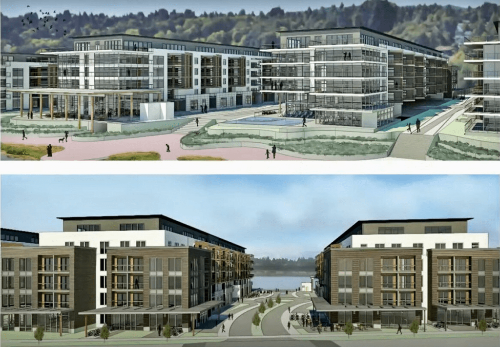
Here we go again. The proposed development at West Bay Yards has been updated and still contains five buildings and 478 units. A SEPA Determination of Non-Significance has been issued. The City’s SEPA Official determined that the anticipated impacts will be addressed by the City’s environmental regulations including the Shoreline Master Program, Critical Area regulations, Drainage Design and Erosion Control Manual, Engineering Design and Development Standards, Municipal Code and the environmental documents submitted with the project application.
Sent to the city: West Bay Yards Shoreline Permit under review by the City of Olympia. Location at 1201 West Bay Drive. File number 21-2845.
This project would set a precedent. It would be difficult to allow such a development along the waterfront and deny neighbors the same. The most immediate concern would be the proposed West Bayview Landing immediately to the north. Impacts of West Bay Yards could be doubled.
The existing site is built on fill that years ago was placed behind a stone riprap wall about 300 feet out from the previous shore. The plan is to knock back the top few feet of riprap and add 35,000 cubic yards of fill up against what’s left out to the high tide mark. Another 26,515 cubic yards will be added below the high water mark for a total of 61,515 cubic yards of fill, covering over 165,000 square feet of aquatic substrate. This fill would bury whatever is there.
Fill doesn’t come with a ready made benthic community. Species composition evolves over time. Larvae, the swimming babies, swim in and adults move across the seabed, both of which occur slowly over time. Puget Sound’s benthos includes over 1,800 species of invertebrates living in or on the bottom sediments including ghost shrimp, worms, clams, crabs, and sea stars which are consumed by fish, birds, and marine mammals. These species choose specific places according to sediment composition. Soils in river and stream deltas are notoriously soft and muddy.
The delta of Schneider Creek is visible a few hundred feet north of the site in aerial photos. This location has been for thousands of years part or the Deschutes River estuary. The salt wedge is often visible a half mile to the north. If the stream wasn’t run through a pipe, its delta would probably come up to the project line. Companion streams often form an integral part of the structure of a river estuary. This development being part of the river estuary will impact larger options.
A VCA (vegetation conservation area) would extend 30 feet landward from the OHWM. The claim is that the VCA would consist of “native coniferous and deciduous trees and shrubs and would screen the shoreline from the upland uses, while also providing enhanced terrestrial habitat functions.” Runoff and other influences will impact this area of transition. How is such a narrow buffer up next to enormous buildings going to supply all these services?
The proposal states that shoreline restoration and planting will improve foraging habitat for birds. An explanation as to how would be helpful. The plan states that “Shoreline restoration is a major component of this project”. To restore something means to return it to its original condition, place or position. Environmentally this would be the historic baseline. Nothing about this plan is anywhere near the historic baseline.
True beach restoration entails bulkhead removal. It does not involve piling material in front of bulkheads. Narrowing West Budd Inlet might increase velocity of waters flowing from the river and tides flowing in and out which combined with the steeper bank would increase erosion. Added to riverine sediments these will tend to find the lowest spots i.e. the shipping berths and channels.
There may be a “solution”. Use gravel as fill. This would allow the growing of Pacific or Japanese oysters which would otherwise sink in soft mud, a possibility that is being touted as a benefit. These are not native species. They have no place in the ecosystem. The loss of species in Budd Inlet has been well documented. These may be birds who in some cases spend the winters here or are migrating through. It may be salmon and other fish all of whom depend on natural conditions. Or it might affect us. Natural marine ecosystems are productive, resilient and maintenance free.
Not that long ago Budd Inlet was a rich productive ecosystem providing habitat for numerous resident and migratory species, some listed as endangered and some locally extinct. What is the current richness and abundance of species that would be buried? How might this impact other species such as diving ducks? What are the cumulative impacts? Any development of this scale in this location should be based on science.
The City’s Shoreline Master Program states that the City recognizes the importance of restoration of shoreline ecological function and encourages cooperative restoration efforts and programs between local, state, and federal public agencies, tribes, non-profit organizations and landowners…restoration actions should be targeted towards meeting the needs of both sensitive and locally important plant, fish and wildlife species…restoration should be coordinated with other natural resource management efforts and plans… restoration actions should consider system-wide benefits… restoration should give highest priority to measures that have the greatest chance of re-establishing shoreline ecological functions and processes… restoration and enhancement measures should be incorporated into the design and construction of new uses… shoreline restoration and enhancement should be considered as an alternative to structural stabilization… shoreline restoration and enhancement projects should protect the integrity of adjacent natural resources including aquatic habitats and water quality… restoration and enhancement projects should be in keeping with the SMP and restoration and enhancement projects should be designed to minimize maintenance over time.
The plan fails on all counts. There is no recognition of ecological function, no effort to meet the needs of sensitive and locally important plant, fish and wildlife species, no assessment of cumulative impacts or system wide benefits. No effort to re-establish shoreline ecological function or protect the integrity of adjacent natural resources. And this is not a cooperative effort. It’s a matter of coming up with a plan and trying to sell it.
Whatever happens here will set a precedent, the objective being a waterfront surrounded by five story buildings and gravel fill. If scientific inquiry or existing rules play a role, it won’t happen.
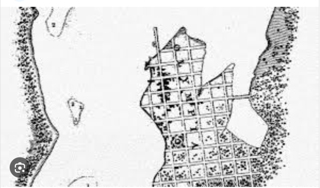
The below drawing shows the fill extending around to the north towards the estuary of Schneider Creek and provides some idea of the scale of the proposed construction.
Screens
Left below shows the increased steepness of the fill over what currently exists. Neither drawing appears to match the above or other drawings.
In the book The Death of Science: The Retreat from Reason in the Post Modern World, Chanda Wickramasinghe states “There is an increasing tendency to form a conclusion first and then collect the evidence to achieve that outcome.” This would be in opposition to established methods of scientific inquiry – observation>hypothesis>test>conclusion. We might also manufacture and manipulate data.
Here in Olympia the plan of action is to start with engineering and design and then strive to mitigate the damage. In practice whole scientific disciplines are either nowhere to be found or mis-applied. Perhaps we can ensure that our community exists in harmony with the natural world, not against it. While development is a perceived feature of “progress” we might ask ourselves: At what cost?
The Port Commission created the Port Economic Development Corporation (Port EDC) in 1983 to facilitate economic development and employment opportunities. Manufacturing, processing, construction and shipping. It’s a laudable idea, as we’ve heard from an assortment of consultants. We’ve got the Destination Waterfront and other plans, which all lean heavily on economic development.
In 2019 The Port of Olympia published the Port Vision 2050 Action Plan, a “Community Informed Plan for the Future”. The 14-month-long community engagement process “engaged thousands of people”; the product reflects their “shared goals and priorities”.
What’s meant by community informed? Who were the targets of “targeted outreach” and what was the level of involvement of each? Were these informed decisions? Participation preceded publication. Were these samples random? Use of the word targeted would indicate not.
Restoration isn’t specifically mentioned anywhere. A lot of people would consider restoration their first choice and restoration was not included among the choices. “The logical fallacy of limited choices, also known as a false dilemma or false dichotomy, occurs when someone presents only two options as possibilities when more options actually exist”. This renders the study invalid. We hear about environmental stewardship, compliance and sustainability. We don’t hear about restoration anywhere in the process. It goes to provisos in the 2050 action plan.
Without nature, industry and development are unsustainable. Northwest economies are grounded in nature. Production and markets will collapse. They always do. In the past we could fall back on nature. If you’re hungry, go catch a fish. That’s no longer an option in Olympia.
Phytoplankton are the base of the food web on which all life depends. Phytoplankton generate oxygen through photosynthesis and sequester carbon as they have for millions of years. They were among the earliest forms of life. They are the reason the earth looks like it does from space. Budd Inlet and particularly East Bay is a federally degraded water body due partly to low levels of dissolved oxygen. Although the correlation is never mentioned, modifications to physical parameters such as dredging, armoring and filling impact biological parameters including phytoplankton and chemical parameters including dissolved oxygen.
Indicator species such as apex predators tell us a lot about the health of an ecosystem. Waterbirds such as diving ducks are especially good indicators for a bay like Budd Inlet. On June 15, 2002 the City of Olympia was presented with the West Bay Habitat Assessment by R.W. Morse. R.W. Morse is the author of several popular field guides and considered a leading expert on Northwest Birds.
Although there were still many birds, the report states that the “biggest surprise of the study” was that the number and diversity of waterbirds had dropped significantly. A mere 15 years earlier 30 to 80 waterbirds would be seen per visit, just between the 4th and 5th ave. bridges. The R. W. Morse Assessment is comprehensive. Fifty six surveys were conducted over an eight month period. Along West Bay they counted 39 species of waterbirds and six raptors, for a total of 15,231 sightings. The authors suggest repeatedly that we should make some effort to find out why the birds were vanishing and have since vanished.
As of 2002 birds facing local extinction included: Red-necked, Horned and Western Grebes, Pelagic Cormorant, Surf Scoter, Barrows Goldeneye, Hooded, Common and Re-breasted Merganzers, Ruddy Duck, Bonaparte’s Gull and Mew and Red-winged gulls. Some were already considered locally extinct including: White Winged and Black Scoters, American Wigeon, Canvasback and Rhinoceros Auklet.
Scoters were predicted to be locally extinct as of 2004, which turned out to be an accurate prediction. Populations Puget Sound-wide were falling more slowly. Populations fell more quickly here because there’s something particularly wrong here. According to other studies as of 1980 sand lance, surf smelt and other critical forage fish were abundant.
The first step in a cleanup should be source control. Here we have a bay mired in dioxin and PCBs, two of the most biologically damaging chemicals known. Though we’re spending plenty determining where these things ended up, the sources have yet to be identified; it’s time for “cleanup” dredging which ironically always seems to occur in channels and berths. If source identification and control doesn’t precede a cleanup the sediments will be recontaminated. In this case we have an a-priori fallacy – choosing and ignoring facts.
We have too many nutrients and too little dissolved oxygen. We’ve lost primary production (healthy phytoplankton populations) and secondary production (healthy zooplankton populations) and spawning and rearing habitat for fish. We know how to fix these things: Daylight streams. Clean up and restore estuaries. Bring back tide flats and salt marsh.
Can we improve ecological function? Can we realistically employ science in our decisions? The baseline should be the way things once were, not the way they are now. 35% of historical coastal embayments have been lost. 74% of tidal wetlands surrounding the shores of Puget Sound have been lost.
The place where a creek enters salt water is called a pocket estuary. Prior to the arrival of Europeans, almost every pocket estuary on Puget Sound was inhabited by a village between 40 and 50 people, representing five or six extended family units.
Estuaries rank among the most productive ecosystems. Rivers and streams slow and broaden as they encounter seawater, expanding the photic zone, the area penetrated by sunlight, and increasing the time water takes to move through. Because of their position at the base of a watershed, estuaries have high nutrient concentrations.
Estuaries are the places where fresh water and nutrients flowing from land encounter and mix with marine waters. Fresh water being lighter than salt water tends to flow out on the surface drawing salt water and marine organisms in underneath. Nutrients are consumed by phytoplankton, tiny plants in a process known as primary production, the origin of life. Phytoplankton are in turn consumed by zooplankton which either grow into larger fish or are consumed by larger fish which are then consumed by larger species and so on up the food web. Persistent mixing patterns, the result of natural structure best illustrated by tide flats are critical to the process. It all happens best in shallow waters in the presence of sunlight and atmospheric oxygen.
In Puget Sound, the most important physical parameters, the estuaries, have been channeled through long culverts, they’ve been dredged for navigation and their shores have been armored with concrete and rock to prevent erosion and provide for industry and development. The Puget lowlands ecoregion is unique, characterized historically by large trees and prairies. Lowland watersheds tend to drain directly to the sound through many streams. Each of these streams has an estuary which together form a “string of pearls” for migrating salmon. In Olympia, 160 miles of surface and near surface waters have been confined to culverts.
The Capitol Lake dam removal is touted as an estuary restoration. Just what this is going to cost is impossible to figure out, there are so many variables. The initial cost of removing the dam is estimated to be between $25 million and $350 million depending on details and who one asks. The long term funding through 2050 has until recently been predicted to come to $66,374,000.
The State’s role was originally handled by the Department of Enterprise Services, previously the Department of General Administration and since turned over to the Department of Ecology. Cost estimates through 2050 have gone up to $400,000,000 which may in fact be low.
To be a complete restoration we’d have to do something about the Deschutes Parkway, like get rid of it. We’d have to deal with nearshore armoring and fill and estuarine culverts throughout South Budd Inlet. Is the dam really that big a problem? The costs and benefits of East Bay, Capitol Lake and West Bay proposed improvements should be considered together. It’s all part of the Deschutes River estuary.
Ecosystem Based Management (EBM) is a seemingly a simple and attainable goal; decisions based on the Best Available Science (BAS). The reality has been rule based management; how well a proposal complies with codes, ordinances and plans which may or may not be science based. The discourse over Westman Mill for example was: Do the appellants have standing and does a stream in a pipe exist?
Many shorelines are experiencing multiple stressors and cumulative impacts. Activities are frequently planned in sensitive areas for reasons other than restoration, activities such as business and real estate development. Work must comply with rules that don’t include restoration. We theoretically can’t damage a site. We can however declare that once a place has been damaged, it shall remain damaged. There’s plenty of ecology occurring in urban settings and lots of room for improvement. The problem is that recognizing something like this would involve scientific inquiry, which is scarce.
We really shouldn’t ignore ecological potential. What values can we protect, restore and enhance? What guidelines might we follow? A narrow band of shoreline serves as a transition zone providing ecologically important connections between the terrestrial, freshwater and marine ecosystem types. These beaches, embayments and delta shorelines are heavily impacted by human changes. The nearshore zone is a strategic focus for Puget Sound recovery.
Doing the right thing isn’t prohibited. The problem is that it also isn’t required. If we want better it’s going to be up to local governing bodies. Restorations like this can only be initiated at a local level. The term restoration has a very specific definition: “bring back (a previous right, practice, custom, or situation); reinstate. Return (someone or something) to a former condition, place, or position”. Building something new that might look like something old is not restoration. Let’s call it what it is.
We can’t permit one property owner the right to do something and deny the neighbor the same right. What happens at West Bay Yards will serve as precedent for what will happen next door at the proposed West Bayview Landing development. What happens at both will determine the future of Budd Inlet. We must consider cumulative impacts.
The City’s 2016 West Bay Environmental Restoration Final Report, written by Coast & Harbor Engineering, claims to contain a “restoration proposal” that is consistent with the “intent and objectives” of the report. The Schneider Creek estuary runs through the middle of the area of development. The report states that the creek “was beyond the scope of the Plan”. How can we declare the most important feature to be beyond the scope of a “restoration proposal”? This is critical habitat for endangered species.
According to a report from the United Nations Intergovernmental Science-Policy Platform on Biodiversity and Ecosystem Services (IPBES), “Nature is declining globally at rates unprecedented in human history – and the rate of species extinctions is accelerating, with grave impacts on people around the world now likely…The health of ecosystems on which we and all other species depend is deteriorating more rapidly than ever. We are eroding the very foundations of our economies, livelihoods, food security, health and quality of life worldwide.”
We have an opportunity — and a responsibility — to advocate for viable solutions. Whether that means preserving critical habitat, creating wildlife corridors, or reevaluating development plans, we must make it clear that economic growth should never include ecological destruction.
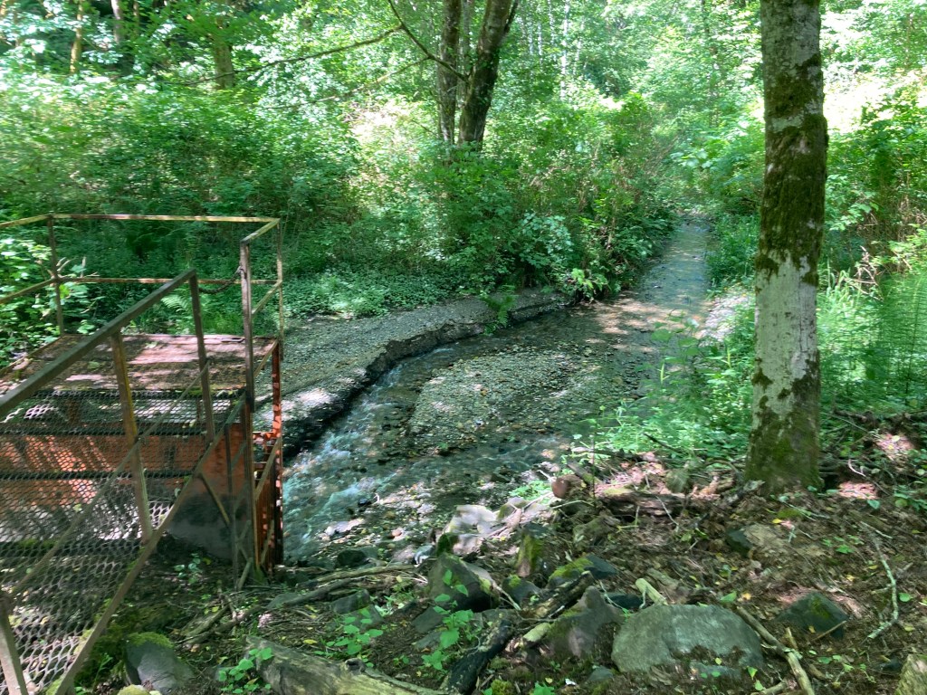
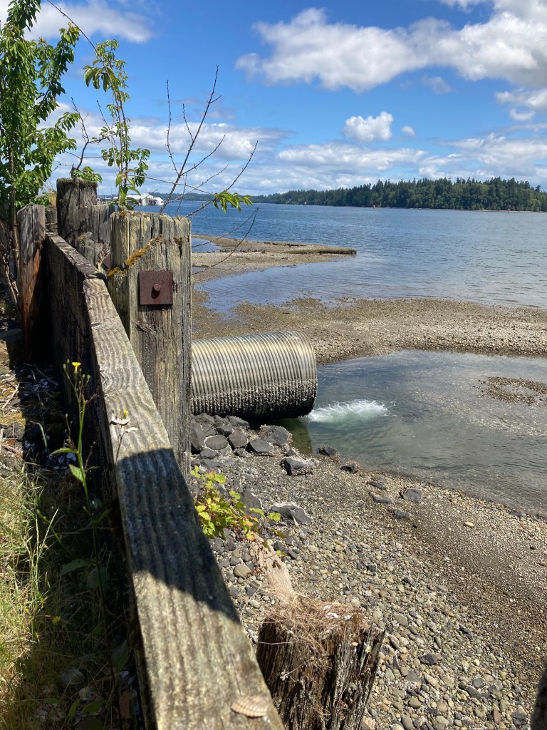
A stream in a pipe is unable to process nutrients because there is no sunlight and hence no plankton. The estuary of Schneider Creek on the western shore of Budd Inlet runs through a 500 foot long culvert. The culvert is intertidal, the tide backs up the entire length. The estuary, is run through a pipe.
Oceanography is the study of physical, chemical and biological parameters. Chemical and biological parameters are generally influenced by physical parameters, the shape and structure of beach and benthic soils and the flow of currents.
If we think we can create a beach, a wetland or some other hydrologically determined geologic feature in a location where one didn’t exist, there’s a likelihood that over time it will return to what it was. There’s a long list of failed mitigation sites. Geology is counted in millions of years while the environment is much more dynamic. Geology is a limiting factor in the makeup of species capable of existing in any given location.
Why not include geology, oceanography and ecology at this stage? If we don’t understand the potential, how can we make an informed decision?
What can we do?
Critical Habitat is habitat that contains features or areas essential for the conservation and recovery of Endangered Species. We’re required to address critical habitat based on the best available science and there has been little relevant science here. A science based innovative plan would qualify for a lot of outside funding. We’d have something to be proud of when we’re done. Such a plan can only be initiated at a local level. The ball is in our court. Let’s not ignore ecological potential.
What do we mean by ecological potential? Let’s say we want to build a building near a stream that’s confined to a concrete pipe. We have two choices: We can ignore the stream. Being in Olympia it legally doesn’t exist; Or we can incorporate the stream into our design. The building might mimic overhanging vegetation or a large boulder. We might begin with enhanced eelgrass beds, tide pools, salt marsh and tide flats and then figure how a building might utilize foundation structure, light wells or other features to mimic nature.
We might want something that would look like Tolmie State Park with buildings plopped here and there as opposed to something dominated by structures with livings things plopped here and there. If so, we’d have to include the idea from the beginning. Natural improvements should be the first question followed by the question of how to make the building fit the improvements. The existing process is backwards.
Places with the greatest potential will have the greatest value when done. Funding for projects with the greatest potential will be most forthcoming. A piece of waterfront in an estuary is going to have tremendous ecological potential. East Bay is a federally degraded water body based on low dissolved oxygen. As bad as it is, this represents great opportunity.
In considering any piece of land our first question should be: Is there anything we can do to improve ecological function? The answer should be based on the best available science. There is no valid reason that assessing ecological function should not precede the design phase. If we’re designing something, a plan is already in place. Ecological potential should be determined prior to design in order to be a part of design.
Our management of forest and agricultural lands, not to mention nearshore and wetlands, is anything but sustainable. There’s an idea, somewhere between collective precognition, emergent eschatology and quantum entanglement, that we can predict the future, especially war and famine, both of which are looking inevitable. Not to give up though, the enlightenment will follow.
Logical fallacies prevail. All of the following have played a roll, some repeatedly ad nauseam. Leading the way is Equivocation. If we see the term “sustainable” we can count on the opposite. There’s the Gish Gallup fallacy, introducing irrelevant material to dilute and confuse. There’s the Red Herring, look over there not over here; the False Dilemma, limited options and false solutions; the Circular Argument, repeating nonsense, the big lie; and others including the Strawman, the Slippery Slope, the Appeal to Authority and the Fallacy of Sunk Costs.
Ad Hominem, characterizing your opponent as a poorly informed, non-professional advocate. Strawman Argument, mischaracterizing an opponent’s arguments Appeal to Ignorance, a position must be true because it hasn’t been disproven False Dilemma, limited options and false solutions Slippery Slope, assuming that something will lead to other things Circular Argument, repeating the same nonsense, the big lie Hasty Generalization, arguments based on a few examples rather than the whole picture Red Herring, look over there not over here Appeal to Hypocrisy, attempt to divert blame Causal Fallacy, assuming cause and effect connections Fallacy of Sunk Costs, we’re already invested and need to continue Appeal to Authority, overstating expertise, if the state OKs it it’s good Equivocation, re-defining words and using words to confuse or mislead Bandwagon Fallacy, some people agree, it must be true Gish Gallup Fallacy, introducing an excessive number of arguments to throw discussion off a-priori fallacy, choosing only arguments that support a claim while ignoring those that contradict a claim.
According to the book Fort Nisqually: A Documented History of British and Indian Interaction by Nisqually Tribal Historian Cecelia Svinth Carpenter, “Almost every freshwater outlet on Puget Sound was, by 1800, inhabited by one band of Indian people or another. Villages of as many as 100 people were located in the estuaries of significant streams…” People had lived here for thousands of years understood the value of stream estuaries. Today’s regulatory system doesn’t. One can always write a letter:
Dear Port Commission and Olympia City Council,
There are thousands of stream estuaries in Puget Sound. In South Puget Sound these pocket estuaries shape virtually the entire length of shoreline. The two river estuaries, the Nisqually and the Deschutes, shape a much smaller length of shoreline.
In Budd Inlet there were native salmon populations in Percival, Moxlie, Indian and Schneider Creeks. There were no salmon in the Deschutes River because of the waterfall.
The area of many river estuaries are expanded by a companion stream, Hylebos Creek for the Puyallup, Medicine Creek for the Nisqually and Moxlie Creek for the Deschutes Rivers.
Despite these realities, stream estuaries get no mention. Moxlie Creek and Schneider Creek, the two largest streams draining into Budd Inlet, are both run through long culverts. These culverts impede salmon passage. They also impact water quality. No sunlight no phytoplankton. No phytoplankton no dissolved oxygen.
Our living in a place doesn’t mean we have to destroy it. Our having destroyed it doesn’t mean it must remain destroyed, even if the plan is to build there. There are ways to incorporate restoration into design but it must be part of the plan from the beginning.
Current plans are to build a total of eight buildings along the East and West Bay waterfronts, in the estuaries of Moxlie and Schneider Creeks. These structures will be as tall as five stories. They will make any real restoration impossible Any reference to science contradicts science. Logic goes out the window.
We often see reference to getting rid of the dam and restoring the Deschutes River estuary as though these things are synonymous. The salt wedge can be seen well north of Schneider and Moxlie Creeks. They are both part of the Deschutes River estuary. Any talk of estuary restoration should include these areas.
The entire length of the Deschutes Parkway will be subject to tidal flux and flow when the dam goes. Placing sediments in front of structures like this will be subject to hydrogeological influences and likely require armoring. Simply getting rid of the dam will be a long way from restoration any way we want to look at it.
If you’re looking for applied science or logic in any of the countless elegant consultants’ presentations before our councils and commissions you’re likely to be disappointed. Don’t look at East Bay look at West Bay, unless we want to develop West Bay then look at the lake and so on.
The so called living shoreline, touted by the City and the Port, is not a restoration of tide flats, salt marsh and overhanging vegetation. In most instances it’s some grass on top of a pile of rock. The two ideas are mutually exclusive. Although we throw the word around, restoring nearshore habitat is not part of the plan.
In 2020, the Port of Everett initiated a shoreline cleanup and habitat restoration at the Port’s vacant Bay Wood property, a 13 acre lumber and mill site at Preston Point. The shoreline restoration created 1,300 linear feet of shoreline habitat and 2,300 LF of upland buffer habitat, cleaned up contaminated soil, and provided space for a new public access shoreline nature trail — the first public access to the site in its history. The $2.3 million project was funded in part by a grant from the Department of Ecology that paid for 90% of the cost.
The entire length of beach and salt marsh has been restored at an otherwise impervious industrial site. The whole length of intertidal and backshore structure will now support natural attenuation. Indeed there’s no shipping dock at the above Everett site. The shore could be restored behind a dock or the dock could be built out from the shore, in the littoral zone. There’s no reason Olympia couldn’t fix the entire length of shoreline. Whatever we want at a site, a warehouse, a hotel, a pile of logs, or heaven forbid a park, there’s no excuse for not doing this.
The Port of Olympia touts its environmental accomplishments. In reality it’s hard to find any substantial accomplishments. Solar panels on a roof here and there? Dredging the navigation channel? A trail on top of a steep pile a rock?
The port is planning on importing eucalyptus pulp from South America. The ultimate impact of replacing rainforest with rows of planted eucalyptus is anybody’s guess. We cut our own forests and ship the unprocessed wood to Asia. What’s it all add up to?
In the 1980s, driving the length of West Bay Drive past Solid Wood and several other lumber businesses, the parking lots were full of cars with bumper stickers reading “Don’t Export Logs and Jobs”. Today those mills are all gone and across the bay the Port is exporting raw logs. And those are only the businesses that were located on the waterfront. It would be difficult to calculate all the mills that are gone because resources are being shipped unprocessed. It’s a third world model, a job killer, not a job creator.
The percentage of a log converted into lumber is generally less than 55% with some studies indicating yields as low as 30-35%. The remaining volume becomes waste. Cutting lumber prior to shipment would cut the number of trips in half per given finished product. A medium sized log ship burns 50,000 gallons per day. It takes two weeks to reach a market in Asia. That’s 700,000 gallons of fuel. Then the ship has to return, probably empty. That’s close to a million and a half gallons per round trip. Exporting lumber instead of logs would cut that number in half per unit of marketable product. Problem is, it would also cut into profit.
The Port’s motto is: “Creating Economic Opportunities and Building Community for all of Thurston County Through Responsible Resource Use”. Creating Economic Opportunities? Responsible Resource Use? Money made goes to corporations not local businesses. Profit goes to shareholders, a small percentage of whom live in Olympia.
Janine Gates’ new book Saving the Nisqually Delta documents a successful community effort to save the Nisqually River estuary from becoming a shipping terminal. The primary aspirant was Weyerhaeuser one of the largest forest product companies in the world, owning more than 12.400,000 acres of land. Weyerhaeuser actually prevailed in the critical appeals and then for some unknown reason backed off. Perhaps the company decided that loading logs at an existing dock at the Port of Olympia made more economic sense than building what would be needed at Nisqually.
Weyerhaeuser touts their “sustainability”. Natural forest soils are rich with microbes and fungi. The ground in a natural northwest forest is spongy. Nobody actually knows how long tree farming, i.e. growing a single species of trees in dead soil with chemicals and killing them early in their life-cycle, can be sustained.
Elected officials care about the environment. The number one concern is climate change. The city and port are going to provide places to charge an electric car. Climate change is a global question. A place to charge a car will have no effect. The problem lies beyond the purview of the city and the port.
Then comes sea level rise. The city and port talk about building a berm around downtown to stop the incoming tide. Downtown is an artesian discharge zone. Over a hundred historic springs and wells dot the area. These are fed into storm drains or capped in ways that frequently fail. The water table is 10 to 20 feet above the surface ground level. A berm will hold water in as well as out.
Local governing bodies are looking for any way to help. Unfortunately, going after the real problem is a particularly challenging option.
In my career as a captain of fishing, charter and research vessels, I’ve had many remarkable interactions with marine mammals. These experiences have led me to believe that the only advantage we have over these species is thumbs. I can’t expect people who haven’t lived my life to share these feelings. I can however expect anyone who sees the above photo to understand what’s at stake here.
We all want the same things. It’s a matter of common sense. It’s like there’s some invisible force. Perhaps it will take a broader effort. Fish migrate along shallow nearshore. Stream estuaries form a “string of pearls”. They all need protection. Damaged places like Budd Inlet need restoration. Janine’s book points out that if people can see something, like the Nisqually estuary, they’re more apt to become involved. Protection has more appeal than restoration. But restoration’s allure grows with graphic illustration. People see it.
The loss of chinook salmon, the SRO Whale’s preferred food, is due in part to the loss of forage fish including sand lance, surf smelt and herring. The web of life in Budd Inlet has crashed. In 1980, 3670 lunes, scoters, grebes and other birds were counted in Budd Inlet and there was a proliferation of forage fish. Today these species are all but gone, nearshore habitat has been decimated giving way to soils laced with dioxin, PCBs and PAHs, toxic chemicals linked to among other things cancer and birth defects. Controlling the sources of persistent toxins is not on the table. Dredging benthic sediments is not source control.
Development and nature can coexist. A good example of what could be can be seen at Tolmie State Park. Buildings are not excluded. They do however exist amid natural hydrogeology. To do this we might begin by assessing the potential inherent in a site. Stream estuaries would be tops – salt marsh and tide flats. Then would come the wrack zone, the upper beach. Potential would then be balanced with feasibility.
Or better yet we might set riparian nearshore areas aside as part of the public trust. Species that are facing extinction rely on them. We couldn’t find a worse place to build eight huge buildings. We couldn’t find a better place to restore. The Port Commission doesn’t have to do this. The City Council is not helpless. An emergency ordinance could be passed to put waterfront developments on hold.
The above ideas were presented orally to both the City Council and Port Commission members and staff on September 23rd, 2024. Citizens are allowed to speak for two minutes to the City Council and three minutes to the Port Commission. Regarding an issue this complex, that’s enough time to sound dull-witted. I followed up with the following letter:
“The Southern Resident Killer Whale (SRKW) population is now critically endangered with around 75 surviving individuals, down significantly from their historic abundance. Multiple lines of evidence (genetic, morphological, behavioral, cultural) support designating the Residents one species. Unlike their neighbors to the north they’re pescatarians, they don’t eat meat. They learn through long standing orally conveyed stories. These marvelous critically endangered orcas are counting on us. We need to do a better job.”
After speaking at council meetings and writing letters, the only realistic option left is the legal appeal. One of the challenges in appeals is establishing standing… how I as an individual or my property will be damaged by a proposed action. I am proposing that I do have standing where cetaceans are concerned for religious reasons. From a recent appeal: “I have greatly enjoyed many interactions with orca whales and other cetaceans. In 1988 I was skippering a large sailboat down San Juan Channel when a hundred or more orcas appeared astern. An exceptionally large orca surfaced in front of us and spy hopped, standing on its tail with its head well out of the water. As we sailed past about 6 feet away it looked at each of us. The orca could have easily snatched a human off the deck for a snack. The whale didn’t do that because of a sacred agreement. Many interactions I’ve experienced can only be explained by the animals’ great intelligence, and my interest in these species’ and other aquatic species’ health and ongoing existence and protection is almost spiritual. Before the Hind Rigveda was written in about 1000 BCE, it was passed down through oral traditions and conveyed in mantras or chants made up of three or four notes, and tones, accents, and pauses. Structuring the message this way made change less likely over generations. Based on my experiences, I believe that whales, dolphins, and porpoises have systems of communication similar to these ancient humans. The differences in behavior, migration, and diet between populations and over time can only be explained this way. To lose such intelligent creatures due to habitat destruction and toxins in our waters would be devastating to me”.
The Puget Sound Lowlands is a unique ecosystem characterized historically by large evergreens, deciduous forests and grasslands. The topography is level compared to steep mountainous lands further from the Sound.
The lowlands is also comparatively urbanized. If we care about this vital area we need to be mindful of urban ecology and hydrogeology.
Streams in the lowlands tend to drain directly to the Sound whereas streams further from the Sound tend to drain to rivers that drain to the Sound. The places of transition, stream estuaries, represent critical processes.
The 1980 Environmental Impact Statement (EIS) for proposed East Bay dredging and filling contains statements by Federal agencies expressing concerns that water quality and species composition would be negatively impacted. The National Environmental Policy Act (NEPA) requires an EIS for major actions that affect the quality of the environment. NEPA does not prohibit the government or its licensees from harming the environment. It does require that the prospective impacts be fully understood and disclosed.
Activities must comply with other environmental legislation including the Clean Water Act (CWA). The overarching purpose of the CWA is to “restore and maintain the chemical, physical, and biological integrity of the Nation’s waters.” 33 U.S.C. § 1251(a). The CWA also establishes an “interim goal of water quality which provides for the protection and propagation of fish, shellfish, and wildlife.” Water quality standards “provide the legal basis for control decisions under the Act.” 40 C.F.R. § 130.0(b). Achieving them is one of the Act’s “central objectives”
The CWA requires the U.S. Environmental Protection Agency to use the “best available science” in developing surface water quality criteria. Total Maximum Daily Loads (TMDLs) are action plans to restore clean water. Section 303(d) of the CWA requires that states identify water bodies — bays, rivers, streams, creeks, and coastal areas — that do not meet water quality standards. East Bay is a degraded water body.
The question brings us to current Port plans to dredge East Bay, the estuary of Moxlie Creek, to maintain Swantown Marina and build the Marine Center building and other structures along the waterfront. It’s a massive proposal with a massive back story. In the 1980 EIS for Swantown Marina, then called East Bay Marina, Federal agencies were opposed to dredging and filling of East Bay as it would lead to a loss of species and reduced dissolved oxygen.
In a letter dated Feb 26, 1980 the USFWS wrote: “It is our contention that the proposed project is not in compliance with Executive Order 11990 since all practicable measures to minimize wetland losses would not be taken. Elimination of the cargo fill area is practicable and would reduce losses by 50 percent. Information recently received from tie Washington Department of Fisheries indicates their firm belief that significant numbers of chinook salmon released from the Percival Cove salmon rearing facility, and possibly large schools of herring and smelt, will be attracted into the marina with the likelihood of increased fish kills due to anticipated dissolved oxygen sags. This presumably would occur under any marina design which entails dredging of East Bay proper. In view of this, we recommend the permit for the project, as proposed, be denied.” (link below page G48)
In a letter dated Feb 28, 1980 the EPA wrote: The project “may not be environmentally acceptable due to the potential adverse consequences for water quality and aquatic resources. Our evaluation of the modeling studies for the proposed marina indicates that any marina development within East Bay proper will reduce the water exchange in the Bay. The consequent increase in flushing times for the East Bay basin would probably result in extremely poor water quality conditions.” (page H-46 to page H-51)
After much pressure from the Port of Olympia and Washington State agencies, the feds consented on specific conditions. The EPA wrote on august 29th 1980: “As stated in previous correspondence, our primary concern with this project has been the high potential for a reduction in water quality, particularly dissolved oxygen concentration in the marina basin… Although we continue to support Alternative 4e as a cost effective preferred alternative, selection of Alternative 4a would be acceptable to EPA if it includes a properly designed and maintained aeration system which will maintain Class B water quality standards within the marina. This is the first time we have approved of an aeration system to mitigate reduction in water quality and our approval is specific to the unique circumstances of the East Bay project. As a matter of policy EPA does not generally support the use of an aeration system as a solution to probable water quality problems in marinas, particularly when design modifications or alternative site locations with improved natural tidal exchange would eliminate the need for long-term energy requiring mitigation systems” (page G44. Plate 13 shows the design of the aeration system)
The story continues in 1991 Budd Inlet Urban Bay Action Program. Below are excerpts of communications from federal agencies (USACE and the EPA):
“Low oxygen levels, often below 3.0 mg/L, occur throughout the southern portion of the inlet in the late summer. Oxygen levels below 5.0 mg/L can be fatal to fish and invertebrates.”
The Port persuaded agencies to go with aerators, like in a fish tank. “Pursuant to the conditions of a Section 404 permit, aerators in East Bay are to be turned on when the dissolved oxygen concentration in the water at the marina falls below 5 parts per million (ppm)… The port has installed 21 aerators in East Bay that are used when dissolved oxygen levels at the bottom of the bay fall below 5 ppm.”
“Planning for the future development of the urban waterfront should include enhancement of water quality and aquatic habitat as key elements. Future plans for the overall development of the waterfront should provide for protection and enhancement of water quality and aquatic habitat.”
“The installation, operation and maintenance of dissolved oxygen (DO) continuous monitors and aerators remain a condition of the East Bay Marina project. The Corps is aware the system does not operate sufficiently to ensure DO levels meet water quality standards. Through the critical summer months, the Corps has allowed the Port to conduct manual titrations in lieu of continuous monitoring. The manual sampling is not scheduled, but rather is conducted on a sporadic basis. If the study shows aerators are not sufficient to compensate for decreased flushing and low DO levels resulting from alteration of the estuary, what contingency actions by the corps are planned to mitigate this?”
“Operation of the originally installed continuous WQ monitoring equipment for DO has failed to provide reliable readings. Other continuous monitoring systems have been considered but found to have similar problems of high maintenance and poor reliability. Therefore, the Port staff performs manual titrations to obtain accurate measurements.”
“The U.S. Fish & Wildlife Service (USFWS) comments on proposed Clean Water Act Section 10 and 404 projects. The agency also reviews mitigation projects. This review can assert that mitigation projects are to be in place prior to the start of the project, and can recommend contingency plans in the event mitigations are later determined to be ineffective. Monitors and aerators were a requirement for dredging in East Bay. USFWS is aware the system has not been sufficient for ensuring DO levels meet water quality standards… Fish-kills resulting from low DO levels are well documented in Budd Inlet. If new data shows that the aerators are insufficient to prevent violations of water quality standards, will USPW recommend WRDA funding for contingency mitigation projects?”
“The (USFW) Service has questions and concerns similar to those expressed by your agency regarding the operation of the continuous dissolved oxygen monitors and aerators. It is our understanding that the original equipment has not been entirely effective, and that alternative equipment is now being used. Of concern to the Service is whether the alternative equipment provides an equivalent level of protection of the resource.”
“Regarding your question on the use of Water Resources Development Act (WRDA) funding, the Service in 1990 recommended to the Corps that funding be provided to mitigate for fish and wildlife impacts caused by the construction of East Bay Marina Project. One of the options that was discussed involved measures to improve (restore) in-water habitat within the East Bay of Budd Inlet.”
“As a condition of dredging for East Bay Marina, the Port is responsible for the operation and maintenance of continuous dissolved oxygen (DO) monitors and aerators located there. Because the monitors are not reliable, the Corps allowed the Port to conduct manual titrations (for assessment not mitigation). This method cannot be considered continuous monitoring, as required, and is performed on an irregular schedule through critical late-summer months.”
“A related issue is that of marina live-aboards turning off aerators during evening hours. Boat owners frequently shut the aerators off, stating the equipment is noisy and stirs waters to a foam that adheres to boat hulls. Port staff assert the switch box cannot be locked for safety reasons. Will the Port agree to install mufflers on the system or to address this problem in another way? Will the Port also place nearby educational signs stating the purpose and necessity of the aerators?”
“East Bay Dissolved Oxygen Monitors and Aerators: We plan to continue to perform manual titrations throughout the critical period. We are currently sampling twice weekly in the early mornings. As DO levels fall, we will switch to daily sampling. Results are reported to the Corps as soon as the titrations are completed (again sampling not solving). There is no practical way to muffle the noise from these aerators, though we have looked into many possibilities. We would have no problem with installing some sort of educational signage nearby. We could try signage at each switch box and see if this is effective.”
In summary: The Port wanted to build what became Swantown Marina in East Bay; the Feds said no that would destroy water quality; the Port said they’d install aerators like in a fish tank; the Feds said we’ve never allowed that and doubt it will work but OK; they did it and it didn’t work.
Under section 1191, the Action Plan Goal is to work cooperatively with all involved parties. “Voluntary commitment to perform the actions set forth in the action plan is the most efficient and cost-effective approach to addressing point and non-point contaminant sources in Budd Inlet. Successful implementation of the action plan will require the cooperation of all parties within the Budd Inlet watershed. City and county agencies responsible for source control and remedial activities include the City and Port of Olympia. The Budd Inlet ecosystem is being stressed and uses in the inlet are restricted because of low oxygen levels and bacterial and chemical contamination.”
Budgeting has forced federal agencies to rely on state agencies who rely on local jurisdictions for interpretation and enforcement of federal law. If it doesn’t happen at a local level, it likely won’t happen.
Since 1980 East Bay has failed to meet thresholds for dissolved oxygen. We’ve seen a dramatic decline in populations of fish and birds. The feds supported West Bay as a location for added moorage and clearly and repeatedly stated their opposition to dredging East Bay.
Where a Federally degraded water body like Budd Inlet is concerned, we’re supposed to adhere to the best available science. Science should be a part of the process from the outset. We might employ chemistry in the analysis of the chemical fingerprints to get a better understanding of sources and pathways of contamination; or ecology in the analysis of plants and animals including plankton; or oceanography to study of how physical parameters like structure and circulation effect chemical parameters like dissolved oxygen and biological parameters like species composition. The current plan includes “sediment catch basins”, large holes dug in the center of the Estuary to catch sediments coming downstream, an idea that contradicts the most basic attribute of estuaries, the long shallow runout. Calling something “science based” doesn’t automatically make it so.
The mechanism by which enforcement of Federal Law has been handed to the State of Washington is largely a result of the Growth Management Act. Not all states have a growth management law. In 1961, Hawaii became the first to pass one. In 1963, the California legislature passed the Knox-Nesbit Act, to regulate city annexations. Between 1970 and 2000, 11 more states passed statewide laws requiring urban-growth boundaries: Vermont (1970), Oregon (1973), Connecticut (1974), Florida (1985), New Hampshire (1985), New Jersey (1986), Maine (1988), Rhode Island (1988), Washington (1990), Maryland (1992), and Delaware (1995), Georgia (1989) and Tennessee (1998). Florida partially repealed its law in 2011.
The Washington State Growth Management Act (GMA) is a state law intended to manage Washington’s growth by designating urban growth areas and preparing comprehensive plans. Rather than centralized planning and decision-making at the state level, the GMA focuses on local control. Counties designate urban growth areas (UGA) and must plan for all urban growth to happen in those areas alone. Cities are not allowed to annex and generally not even to extend urban services to places not within the urban growth area. The state forecasts population growth for each county and the county is required to designate where development to support the future population will happen. The Growth Management Hearings Board hears and determines allegations that a government agency has not complied with the GMA or the related Shoreline Management Act (SMA, Chapter 90.58 RCW).
Arguments in favor of the GMA are that it makes it hard to develop rural lands outside the UGAs and without the GMA, urban sprawl would be rampant. “Focusing on what’s allowed inside UGAs misses the bigger picture of what’s not allowed outside UGAs. Yes, development inside UGAs is easier and every last square inch theoretically could be built out but all land isn’t buildable to urban density. Its steep slopes, BPA power line easements and FEMA floodways. Even if wetlands could be developed at urban levels it would be economically infeasible and the GMA doesn’t eliminate all other laws and restrictions”. (email from anonymous source)
Even if this were true it’s not ecosystem based thinking. The all important and unique Puget Sound Lowlands Ecoregion has become heavily developed, especially the waterfront and estuaries.
The above map shows the Puget Sound Lowlands Ecoregion as divided into areas of intensive urban, urban character residential, rural character residential and natural preservation and conservation. The closer we get to the water the closer natural preservation and conservation gets to zero.
Costs of bringing Swantown Marina and the shipping terminal up to serviceability are estimated to run $190 million. This will include dredging the navigation channel and depositing the sediments on the peninsula. The marina and all pilings will be removed and replaced. These costs will fall largely on the local public. On the other hand, costs for restoration are unknown because restoration has never been considered. They’d be covered largely by grants from federal agencies because endangered species are involved. Add money from foundations and philanthropists and costs would surely be covered.
local jurisdictions to work together toward a cure — to find holistic, natural solutions — to recognize the interrelationships of physical, chemical and biological parameters. We need salt marsh, tide flats and streams. Natural nuances. We can use these features to our advantage or our disadvantage. Natural marine ecosystems are productive, resilient and maintenance free.
Concerning the “cleanup”, dredging up contaminated sediments and burying or taking them away, there’s another option — natural attenuation.
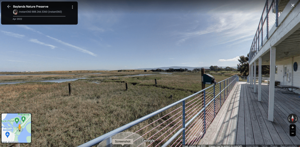
Below is a single structure surrounded on all sides by salt marsh, what was the Palo Alto Yacht Club, the place I learned to sail many years ago. Now part of the Baylands Nature Preserve, some marina pilings are still visible.
All that was done was pretty much nothing. Allow the salt marsh and tide flats to recover through sedimentation. As Black Elk said — we don’t have to fix nature, we just have to stop making nature sick — allow nature to do nature’s thing.
We have bioremediation done by bacteria and fungi. We can enhance these functions with varying effectiveness, on or near the surface.
There’s also photo-degradation — exposing chemicals to sunlight — again on or near the surface.
This is also the bioactive zone, the zone where plants and animals live. Sunlight and bioremediation fix the zone in which plants and animals live. If our goal is to avert the entry of toxic chemicals into the web of life we might consider not inverting or dredging the structure. That’s of course after we’ve identified and controlled the sources. This doesn’t mean abandoning marinas.
Given the initial Federal opposition to dredging and placing Swantown Marina in East Bay and that their concerns for a drop in dissolved oxygen have come to be, dredging again may be a dubious proposition. Instead the marina itself might be minimally dredged and in shallow areas reserved for shallow draft vessels i.e. houseboats. This could be tied into a houseboat construction operation. A narrow channel might be dredged or access to the marina and Boatworks be done at high tide.
The Moxlie Creek culvert is over 100 years old and well past it’s expected life span. The City could wait for a catastrophic failure or take proactive action. Daylighting the stream would improve dissolved oxygen in East Bay. No sunlight no phytoplankton. No phytoplankton no dissolved oxygen. Funding might be brought in from the NEP, the Rose Foundation and other sources.
We might create a new marina at the current location of West Bay Marina and the Dunlap log booming site using dredge spoils from Dunlap to fashion a land spit to protect it from winds from the south and sediments from the river. Often streams in areas of long shore currents caused by a river, which is the case here, have such a feature. We see this at Tolmie State Park. This marina would serve deep draft sailboats and power cruisers.
The traffic increase on West Bay Drive would be akin to what currently goes into the Swantown parking lot, i.e. minimal. The concern would be, as it currently is, that vehicles merging onto West Bay Drive from the north have poor visibility looking back up the hill. The solution would be to reshape that intersection in conjunction with daylighting the Schneider Creek estuary.
Meanwhile, the City is moving ahead with plans to allow the construction of eight buildings up to five stories tall along the West Bay shoreline. The plan ignores basic fundamentals. Questions about structure and function of marine ecosystems are absent. We start with engineering and design and then strive to mitigate the damage.
The current plans for East and West Bay contain no rigorous science. On this and other points they may be in violation of the Clean Water Act and the Endangered Species Act. Budd Inlet is a federally impaired water body. The sediments are contaminated with among other things dioxin, one of the most biologically damaging chemicals known. It does not occur in any quantity in nature but rather is a by-product of human activities. Surface benthic samples have contained high levels of dioxin indicating that sources continue to enter the bay, probably from land since that’s where human activities generally occur.
The EPA Ground Water Issue for Dense No-Aqueous Phase Liquids tells us that: DNAPLs like dioxin containing pentachlorophenol are non-aqueous, they don’t mix easily with water so they won’t necessarily show up in water samples taken from wells; they’re not highly volatile and won’t necessarily show up in the vapor phase; and a point is reached at which DNAPLs no longer hold together as a continuous phase, but rather are present as isolated residual globules. As a result, the only way to effectively sample for DNAPLs on land is to take numerous core samples. The only sensible way to take numerous core samples is to do so prior to planning and construction.
Somehow, it’s been decided that taking core samples on land isn’t necessary. They weren’t taken at the Westman Mill development. They won’t be taken prior to expansion of the Hands on Children’s Museum. Citizens are told that taking core samples on land would be too expensive. How is it that we can afford to take over a hundred samples from a boat and none from a truck?
Surface benthic samples taken in the bay are generally the most recent buildup of sediments. As we go down in sedimentary rock we go back in time. Surface samples have been considered to be the top two centimeters. Getting just the top two centimeters can be a challenge. When I’ve done this, we used a Van Veen shovel. Too deep, sediments come out the top. Too shallow, you get nothing.
Another way of looking at sediments is called the biotic zone, the depths at which things live. This is generally the top ten centimeters. In the analysis of Budd Inlet, we’re taking the top ten centimeters off of a core sample. In the old days, this would have been considered more in line with a bioassay than a surface sample. Things have changed.
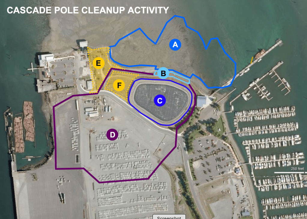
The Department of Ecology entered into an agreement, Amendment 2 of Agreed Order DE 6083 with the Port of Olympia on the cleanup of Budd Inlet. From June 9 to July 10, 2023 they held a comment period. There were 47 comments grouped under the general heading that sources and pathways, likely originating from Cascade Pole, have not been identified and controlled and that sources should be controlled before any construction. Ecology’s response to all these comments is contained in four redundant paragraphs stating things like: “Ecology recognizes that the Cascade Pole site was a source of contamination to Budd Inlet sediment in the past. Substantial cleanup actions were conducted at the Cascade Pole site upland and adjacent sediment between 1993 and 2010 to address sources of contamination from Cascade Pole to Budd Inlet. The Port continues to monitor, operate, and maintain the cleanup action at the Cascade Pole site to be sure the remedy remains protective. If monitoring data show the remedy is no longer protective, then MTCA requires more cleanup. This is true for any site being monitored, not only Cascade Pole.”
This doesn’t answer those 47 concerns. The remedy has not been protective. The monitoring data is full of holes. A comparable number of comments expressed concern that EPA’s protocols to identify DNAPLs are not being followed. Ecology’s verbatim response is:
“We have used and will continue to use the best available protocol to screen and test for DNAPL at cleanup sites. Creosote is a DNAPL that is clearly visible and detectable in sediment samples with our senses. To provide information regarding the potential presence of DNAPLs, sediment surface and subsurface core samples collected during data gaps investigations will be field screened for the presence of creosote DNAPL, such as by sheen testing at the time of sampling. If field screening suggests the possible presence of DNAPLs, a sample of that sediment will be submitted for chemical analysis. Thus far, surface sediment cores from East Bay have not detected the presence of DNAPL associated with the Cascade Pole site.”
In other words, we don’t have to follow established protocols, we’ve got sheen testing and sheen testing tells us dioxin source control is no longer a concern. The Washington State Department of Ecology has placed the bar very low. An earlier blog post entitled The City’s Shoreline Master Program Needs a Metamorphosis explains the City’s shortcomings in greater depth.
The problem isn’t deliberate malfeasance or corruption. It’s a mater of politics dictating policy and politics not understanding what’s at stake. Doing the right thing isn’t prohibited but it’s also not required. The existing system hasn’t gotten the job done. If we want better it’s going to be up to local governing bodies. The County, the City and the Port just need to step up to the plate.
Let’s determine fate and transport, let’s protect future generations and improve water quality and bring back locally extinct species. We want to expand tourism? People don’t go to a tourist mecca like Santa Cruz to see a building, they go to the beach.
Olympia is at a crossroads. On the one hand the city will become a model of urban estuary restoration. On the other a gargantuan monument to human indifference.
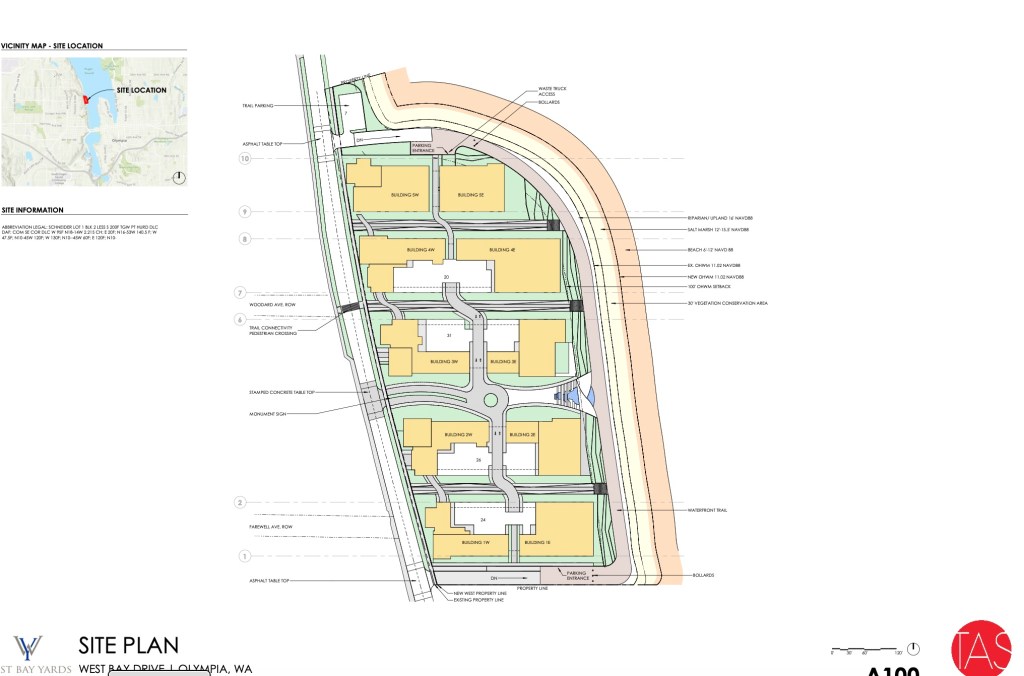
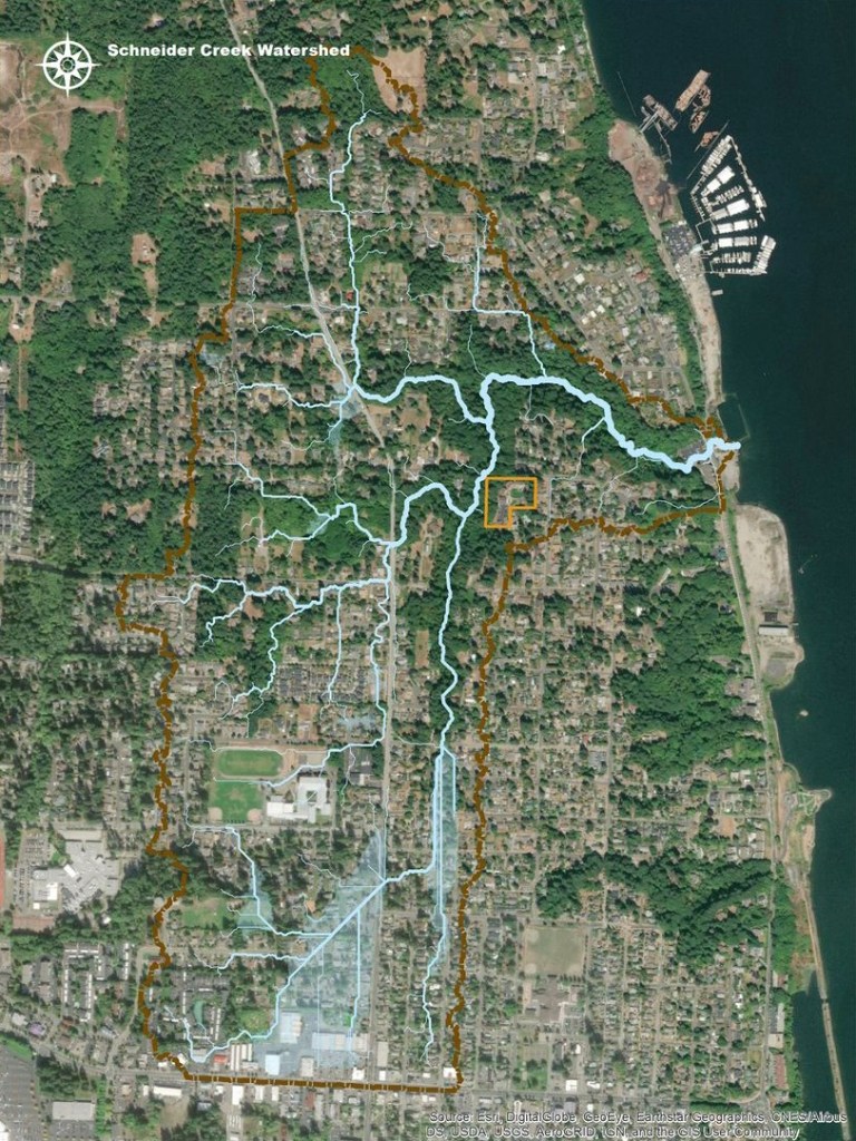
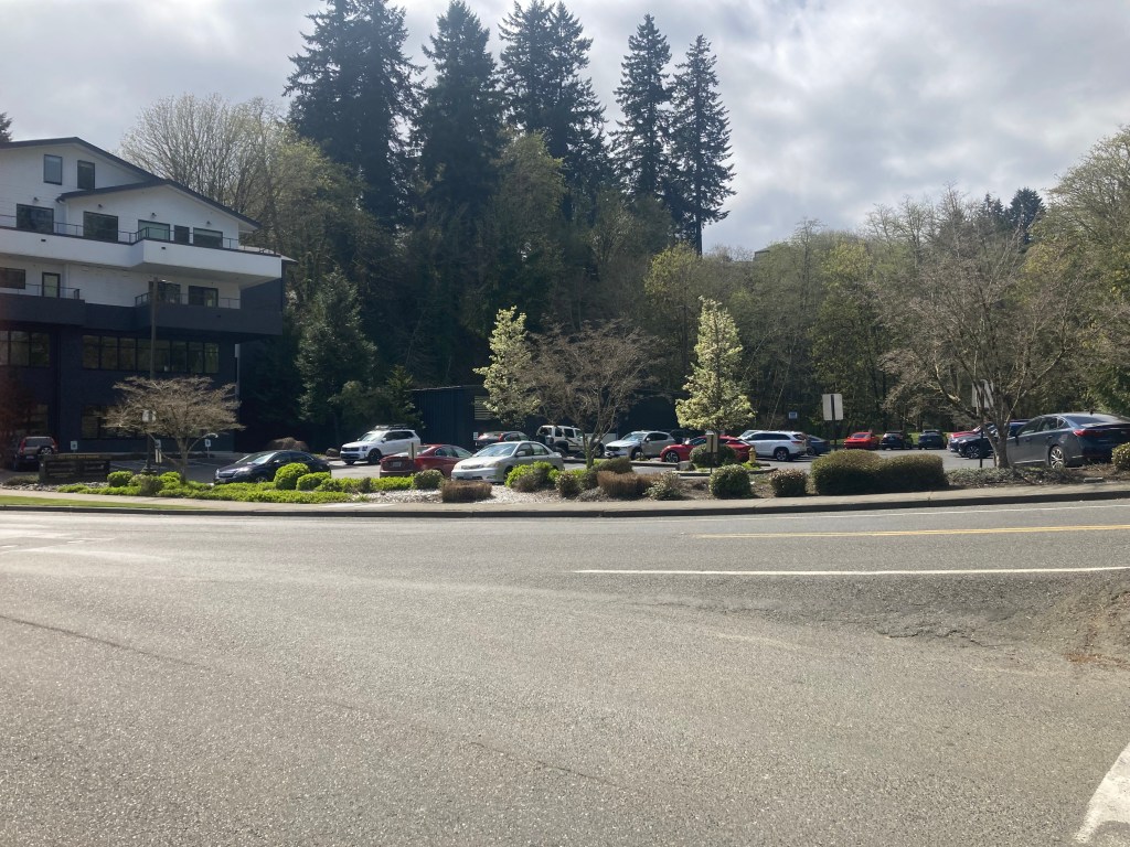
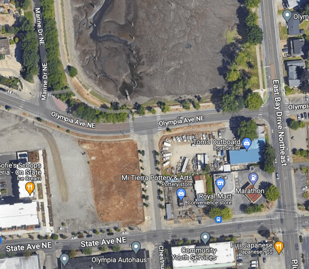
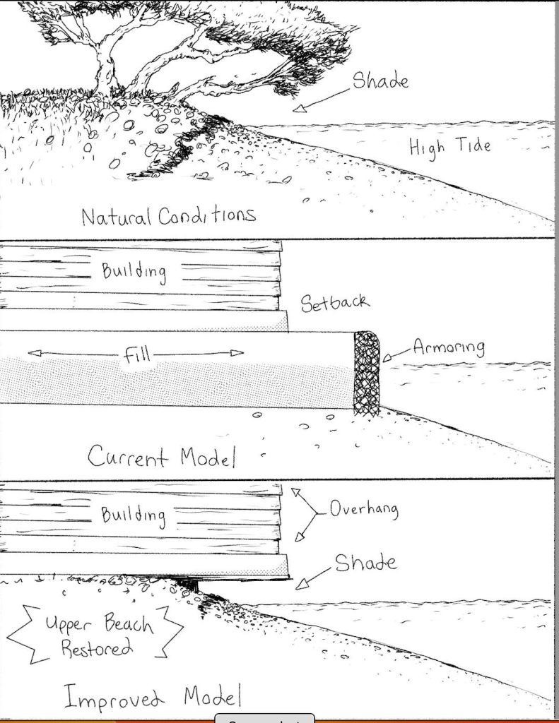
As of this date, June 1st 2024, the City of Olympia is looking at two proposed waterfront developments. West Bay Yards occupies the old Hardel site and West Bayview Landing lies to its immediate north. They include a total of eight buildings five stories tall and several smaller buildings. The permitted setback is 30 feet from the high water mark.
West Olympia is dominated by the Schneider Creek watershed
The most significant feature along West Bay is the Schneider Creek estuary, which currently runs through a 470 foot long culvert. The neighboring Schneider Creek watershed is beautiful and can be seen from the Smyth Landing parking lot.
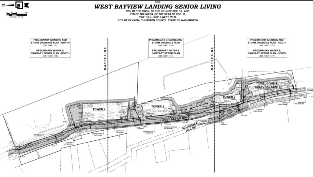
The plan is to run the estuary between Tower 2 and the Welcome & Cultural Center pictured below
This is a critical water body. The salt wedge is visible to the north meaning this location is within the Deschutes River estuary. The Schneider Creek estuary is an estuary estuary. Estuaries are where fresh water and nutrients enter the marine environment. They’re where the web of life begins. This estuary will be jammed between huge buildings in a pipe.
The “restoration proposal” has been designed to be consistent with the intent and objectives within the City’s 2016 West Bay Environmental Restoration Final Report, written by Coast & Harbor Engineering. The Schneider Creek estuary runs through the middle of the area of proposed development. The report states that the creek “was beyond the scope of the Plan”. How can we declare the most important feature beyond the scope of the Plan? This is critical habitat for endangered speccies.
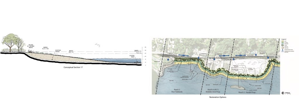
Construction of the “shoreline restoration” would entail the placement of approximately 39,530 cubic yards of fill over approximately 165,000 square feet of aquatic substrate below the OHWM (ordinary high water mark). Most of this is gravel. Including cumulative impacts we could easily triple these numbers, burying existing benthic communities and significantly modifying the historic shape and structure of the bay.
Let’s say someone wants to build a five story building right at the water’s edge. Not allowed. Extending the ordinary high water mark (OHWM) out with fill moves the setback out so they can build on what’s currently the water’s edge. That’s the driving wheel here.
It would be unfair to allow someone to do something and prohibit their neighbor from doing the same thing. What happens here will serve as precedent for what will happen throughout Budd Inlet. We must consider cumulative impacts. The plan has been designed to be consistent with the intent and objectives within the City’s 2016 West Bay Environmental Restoration Final Report, written by Coast & Harbor Engineering.
Schneider Creek will remain in a pipe. No sunlight no phytoplankton. No phytoplankton no dissolved oxygen. We just have to declare it to be beyond the scope of the Plan.
The OHWM (ordinary high water mark) is a line paralleling the shore characterized by the landward limit of salt water tolerant vegetation. Construction of the “shoreline restoration” would entail the placement of approximately 39,530 cubic yards of fill over approximately 165,000 square feet of aquatic substrate below the OHWM. Most of this is gravel. The idea of using fill to create a new nearshore is not a restoration. Will the area of the littoral zone be reduced? What will happen to the existing benthic community? Is the neighboring shore a source of contamination? Would piling soil in front of the site impede a cleanup if one is necessary?
That’s below the OHWM. Now let’s look above the OHWM. A VCA (vegetation conservation area) would extend 30 feet landward from the OHWM would be established along the 1,100-foot waterfront, extending 30 feet landward from the OHWM. . The claim is that the VCA would consist of “native coniferous and deciduous trees and shrubs and would screen the shoreline from the upland uses, while also providing enhanced terrestrial habitat functions.” Tidal influences, runoff and other unforeseen influences will impact this area of transition. How is such a narrow buffer up next to an enormous building going to supply all these services? The tide occasionally comes up higher than the ordinary high tide mark and there will have to be an area of transition. Whether 30 or 15 or however many feet, how is such a narrow buffer going to supply all these services?
Budd Inlet is a degraded water body. Benthic sediments are contaminated with dioxin and PCBs. Water quality is poor, being low in good things and high in bad things. We’ve seen a dramatic decline in species. Today we’d likely see no waterbirds. If one could find a living fish one would be poorly advised to eat it.
The Estuary Restoration Act has made our nation’s estuaries a national priority. The United Nations General Assembly has declared this the “UN Decade on Ecosystem Restoration”, a call to action recognizing the need to massively accelerate global restoration of degraded ecosystems, with particular emphasis on restoration of “blue” coastal ecosystems.
At West Bayview Landing Senior Living Apartments 20 percent of the units will be for those who earn 50 percent or less of the area median income. The principal developer is Pacific Northern Construction, the private development partner of the Senior Housing Assistance Group, perhaps better known as SHAG. SHAG developed the Boardwalk apartments in downtown Olympia, held them for about 15 years and sold the development.
An overriding policy from the City Council has been that by giving tax and impact fee breaks, developers will build affordable housing, resulting in a decrease in homelessness. What’s considered affordable isn’t really affordable for the average homeless person but the additional units will drive prices down regardless. It’s simple supply and demand. We just need to turn planning over to developers and pick up the tab. Like in San Francisco and New York (somebody’s also got a bridge for sale).
It would be a challenge to come up with a worse place to build something like this or a better place to restore ecological function. In all the assessments and checklists associated with West Bay, Schneider Creek appears to have been deliberately omitted, the emphasis being placed on the Port (Rat) Lagoon to the south. We’re admitting that on private property there will be no restoration. We should remember that the lagoon was set aside as mitigation for destroying East Bay and the Feds would have to be convinced that modifications to a 100 year old benthic community would be a good thing.
If we’d include the scientific discipline of oceanography in the regulatory caldron, the Schneider Creek estuary would come to the top. Though Schneider Creek is a salmon bearing stream, this is not entirely about fish. Budd Inlet is degraded by low levels of dissolved oxygen. These factors are especially significant in an estuary where fresh water and nutrients mix with salt water and marine organisms.
The City Shoreline Master Program, Ordinance #7280, Effective June 29, 2021, clearly states under section 2.34 Restoration and Enhancement Policies:
A. Olympia recognizes the importance of restoration of shoreline ecological functions and processes and encourages cooperative restoration efforts and programs between local, state, and federal public agencies, tribes, non-profit organizations, and landowners to address shorelines with impaired ecological functions and processes.
B. Restoration actions should restore shoreline ecological functions and processes as well as shoreline features and should be targeted towards meeting the needs of both sensitive and locally important plant, fish and wildlife species as well as the biologic recovery goals for State and federally listed species and populations.
C. Coordinate restoration and enhancement with other natural resource management efforts and plans.
D. Consider restoration actions outside of the shoreline jurisdiction that have a system-wide benefit.
E. When prioritizing restoration actions, the City will give highest priority to measures that have the greatest chance of re-establishing shoreline ecological functions and processes.
F. Incorporate restoration and enhancement measures into the design and construction of new uses and development, public infrastructure (e.g., roads, utilities), and public recreation facilities.
G. Shoreline restoration and enhancement should be considered as an alternative to structural stabilization and protection measures where feasible.
H. All shoreline restoration and enhancement projects should protect the integrity of adjacent natural resources including aquatic habitats and water quality.
I. Design, construct, and maintain restoration and enhancement projects in keeping with restoration priorities and other policies and regulations set forth in Olympia’s Shoreline Program.
J. Design restoration and enhancement projects to minimize maintenance over time.
K. Shoreline restoration and enhancement should not extend water-ward more than necessary to achieve the intended results.
L. Permanent in-stream structures should be prohibited except for restoration and enhancement structures, and transportation and utility crossings as described elsewhere in this Program. In-stream structures should provide for the protection and preservation of ecosystem-wide processes, ecological functions, and cultural resources. The location and planning of in-stream structures should give due consideration to the full range of public interests, watershed functions and processes, and environmental concerns, with special emphasis on protecting and restoring priority habitat and species.
Restoration and enhancement projects, such as those envisioned in the West Bay Environmental Restoration Assessment Report for some shoreline reaches, may include shoreline modification actions provided the primary purpose of such actions is clearly restoration of the natural character and ecological functions of the shoreline.
None of this has made the discussion. Is the SMP just talk? Real science based restoration isn’t even an option. We’re supposed to address this problem, not fix things so they can never be fixed.
Congress enacted the Clean Water Act “to restore and maintain the chemical, physical, and biological integrity of the Nation’s waters”. Under the Endangered Species Act numerous species are facing extinction. Some live here, some migrate through. All are impacted. The waters of Puget Sound are connected and all species are mutually dependent.
This process began with hiring architects and consultants to plan design and engineering. The second step, where we are now, is navigating the permitting process, the goal being to do the minimum required. Some sand will be piled along the waterfront to create a beach which erosion and transport in a riverine area like this will soon wash away.
A SEPA checklist was completed. Among other questions there’s: Will the project require any work over, in, or adjacent to (within 200 feet) the described waters? The answer is “No work will occur directly in the described waters”. That wasn’t the question. The answer should be: Yes work will occur directly over a Type F fish-bearing stream.
Strangely, nobody’s considered flipping the model, that is, piecing developments into restorations instead of restorations into developments. Engineering and design may be of high quality but science should come first. Science tells us what to do. Engineering tells us how to do it. We could piece design into restoration by mimicking details of ecological function. This would facilitate permitting and funding. Calculating minimum requirements, striving for whatever we can get away with, it’s a way of thinking that doesn’t recognize potential. Nonsense prevails. Nobody benefits.
The proposal must now be reviewed against the city’s comprehensive plan, city code, the state Environmental Policy Act, and the city’s shoreline master program and obtain a shoreline substantial development permit. The first comment period doesn’t end until June 20, 20924. Send comments to Associate Planner Jackson Ewing at jewing@ci.olympia.wa.us.
It would be a challenge to come up with a worse place to build something like this or a better place to restore ecological function. In Washington state, unlike Oregon, California and other states, waterfront lands can be privately owned. The image of all these buildings along the waterfront will cause wonder and disbelief elsewhere.
It’s all about the money. There are no benefits in the obsessing over wealth. Dante refers to the seven levels of Purgatory not in spiritual terms but in potential qualities of the human condition, a reckoning to my thinking, the sources of human misery.
Pride. Love of self and contempt for one’s neighbor. It’s the source of all the others.
Envy. A desire to deprive others of theirs.
Wrath. Spite and a desire for revenge.
Sloth. Failure to do what you know you should.
Greed. A desire to acquire more than you need.
Gluttony. Over-indulgence, over consumption.
And number seven, lust. For money, food, fame, power or sex, referring specifically to turning sex into a commodity.
Something is seriously wrong here. There comes a point where our cumulative undertakings go so far off track as to constitute a violation of the Public Trust Doctrine, an “ancient legal doctrine under which some waters, tidelands and wildlife resources of the State are held in trust for all of the people, and the State acts as the Trustee to protect these resources for present and future generations.”
There’s a prevailing belief that everything is fine in Budd Inlet. Some of us who’ve been around for a while might not agree. Things have changed dramatically. Ron Secrist was born January 10th 1936. The family lived at the mouth of Schneider Creek. I had the pleasure of interviewing him a decade ago.
On the west side of what is now West Bay drive and on the south side of the Schneider Creek estuary was a home occupied by a gentleman named Demon. The Schneider household was also on the west or inland side of the road. Behind the Schneider household on the hill above to the north was the location of the orchard originally planted in the 1860s by Konrad and Albertina Schneider.
West Bay drive crossed the estuary at its current location. The estuary ran under the road in a culvert that was approximately 40 feet long and four feet in diameter. The bank near the culvert was reinforced with rock riprap. The tide flowed freely through the culvert.
Inland, to the west of the Schneider property was an area of “saw grass”, grass a foot or more tall that would cut you if you walked through it. The area completely flooded at high tide. The grass would lay down at certain times of the year. The estuary extended well up into the valley. The banks heading up the valley were steep, the favorable more level spots being closer to the bay.
On the east side of the road there was a large boathouse and a large over-water warehouse where fruit was packed in sawdust for shipment. There were also a couple of docks and floats and the bank here was armored with a log bulkhead that allowed small ships (coastal freighters about 60 to 70 feet) to pull up to the warehouse. There were several large trees including an ancient cedar and there was a large oyster midden on the north end facing the estuary. Artifacts and evidence of Salish residence including a stone tool that appeared to be for grinding grain and remnants of deer bones were throughout the Schneider property.
When the stream reached the sound it made an immediate turn to the left or north, past the Schneider property. On the outer, eastern side a long sand spit paralleled the shore heading north. This was sand, not mud. On the shoreward, western side of the estuary the bank was mud but not soft mud. A person could walk on it and it was full of ghost shrimp. (This same feature, an extended sand spit bent by the flow of currents, is today apparent at Tolmie State Park).
Schneider Creek supported a large population of humpys or pink salmon. It probably also supported chum. The variation between years was significant. Some years the stream was “full” of spawning fish.
On one of the family docks Ron could catch 100 shiner perch in an hour fishing with a single hook baited with pieces of pile worms that he gathered by busting up old cedar pilings with a blacksmith’s hammer that he’d found on the site. He says you had to be careful with the worms because their heads could cut you.
There was a cousin who shot a large number of “salt water ducks” (mergansers, scoters, harlequins etc) from a rowboat in an hour or so. As Ron recalls, it was a foggy day and the gunman simply picked them off as they flew past in endless droves. There were often dead ducks on the road by the bridge that had hit power lines in flight. In those days diving ducks were so plentiful they were almost viewed with disdain.
His father had a large rake that he used to rake smelt into a boat in front of the property. He could fill the boat in an hour or so. Surf smelt were very plentiful. Several varieties of clams were also plentiful.
Ron remembers mats of long sinewy stringy grasslike material that he thinks might have been some kind of seaweed or perhaps sea grass but he couldn’t say for sure which. He also remembers lots of what was almost surely sargassum macro algae that had small air pockets that popped when kids stepped on them.
He recalls seeing two inch chambered jellyfish and larger egg shaped jellyfish, lots of bullheads (sculpins) and lots of dogfish.
Heading south in the area of Reliable Steel was where trains would drive out over the bay on a log dock and dump logs into the bay. The logs were rafted up into a series of large booms that virtually filled the southern bay. These booms were towed to various parts north to be processed and shipped. To the north of the Schneider property was Avery’s mill.
When the Demon property was purchased by the Smyths, they knocked down 100 to 150 feet of high bank and used the soil to fill the Schneider Creek estuary which now runs through a long culvert. The estuary today is a parking lot.
Ron doesn’t recall ever seeing an algae bloom or die off. The estuary had a wonderful smell. When he hears gulls he still gets chocked up thinking of how beautiful Budd Inlet was during his youth.
According to the 1980 East Bay Marina EIS, ghost shrimp and mud shrimp were abundant and widely distributed throughout South Budd Inlet. Perch, flounder, mussels, clams, shore crabs and polychaete worms were all abundant as were many birds.
On December 22, 1979, a census taken by Black Hills Audubon members of East and West Bay totaled 3670 birds. There were 35 species including various grebes, scoters, lunes, mergansers, Barrow’s Goldeneye, Ruddy Duck, Bonaparte’s, Mew and Ring-billed Gulls, American Wigeon, Canvasback, Rhinoceros Auklet, and American Coot. In 1986, 812 waterbirds were counted (21 species). By 2000 the number was down to 168 birds (16 species). Today, it’s few to none.
What’s happened between 1980 and today? The answer is partly low levels of dissolved oxygen due to structural modifications, things like long culverts. There’s no sunlight in a pipe. No sunlight no phytoplankton. No phytoplankton no dissolved oxygen. Two of the principal watersheds in Olympia, Moxlie and Schneider Creek, are led through long culverts. There is also loss of salt marsh, the upper beach and tide flats.
Budd Inlet is in sorry shape. Species are in decline, water quality is in the tank and persistent toxins continue to spread. According to the U.S. Government Accountability Office, “Washington state has failed to meet federal requirements that help prioritize cleanup efforts in Puget Sound to help salmon and steelhead listed as endangered”. (1)
Low dissolved oxygen and loss of habitat, a double edged sword
Low dissolved oxygen is typically attributed to nutrient loading from septic tanks, fertilizers and other sources. Excessive nutrient loading can lead to algal overgrowth which blocks light that’s needed for plants such as seagrass to grow. When the algae and seagrass die, they decay and dissolved oxygen drops.
Nutrient overloading in one place can also be the result of nutrients no longer being consumed in another place. In a normal stream there’s phytoplankton, tiny plants that consume nutrients and incorporate them into the food web. Olympia sits on 160 miles of culverted surface waters. There’s no sunlight in a pipe. No sunlight no phytoplankton. No phytoplankton no dissolved oxygen.
There’s the hyporheic zone, the area beside and beneath a functional stream where plants, bacteria, fungi and other organisms consume nutrients and feed energy up a web of life.
When freshwater meets saltwater, freshwater being lighter flows out on the surface creating mixing patterns that bring nutrients to the surface where marine organisms consume them and are themselves consumed in a dance of life. All this happens best in shallow water in the presence of abundant sunlight and atmospheric oxygen. Tide flats are one of natures perfect designs.
Physical parameters like shape and structure impact chemical parameters like dissolved oxygen and biological parameters from tiny plankton up to the largest whales. Structural modifications in and around Budd Inlet have led to reduced dissolved oxygen.
Toxic Pollutants
Benthic sediments, sand and mud on the bottom of the bay, are where contaminants tend to settle. The closer to the surface, the more recent the sediment. Contamination in surface sediments is an indication of uncontrolled sources. Getting surface samples can be a challenge.
Surface benthic contamination in Budd Inlet indicates uncontrolled sources of dioxin. The chemical composition is consistent with wood treatment chemicals. Being mixed with hydrocarbons these chemicals are mobilized, they spread rather than staying put. Dioxin hot spots point to adjoining lands, locations of past human activities. We can determine if these locations are sources of dioxin, if we choose to, by taking and analyzing core samples.
What’s being done
A City of Olympia Comprehensive Plan update is required every ten years. The deadline to complete this update is June 30, 2025. The plan is to look out to the year 2045.
Olympia’s Shoreline Master Program (SMP) includes policies that “support reasonable private and public uses of the City’s shorelines (within 200’ of lakes, rivers, streams, wetlands, and Budd Inlet) while protecting aquatic wildlife and their habitat.” Most recently updated in 2021, the SMP is required under the State’s Shoreline Management Act. Some regulations from the SMP are included in other sections of Olympia’s Municipal Code, such as the Critical Areas Ordinance. There’s also the Urban Forestry Manual, the Habitat Stewardship Strategy and Olympia’s Storm & Surface Water Utility, whose mission is to “prevent flooding, improve water quality, and protect and enhance aquatic habitat. These particular plans and policies are important to helping the City prepare for sea level rise and other climate-related challenges”.
Climate change and sea level rise are safe subjects for local jurisdictions because any solutions are beyond their purview. If taken seriously we’d see that the perfect machine for breaking down CO2 is plant life including phytoplankton. Phytoplankton produce half the earth’s atmospheric oxygen. When we add other plant life, marine organisms may be responsible for 70% of the earth’s atmospheric oxygen. The choices were clearly explained years ago. The best local response to climate change and sea level rise is to restore nearshore estuarine function. (2)
In 2019 The Port of Olympia published the Port Vision 2050 Action Plan, a “Community Informed Plan for the Future”. What’s meant by community informed? Who were the targets of “targeted outreach” and what was the level of involvement of each? Were these informed decisions? Participation preceded publication. Were these samples random? Use of the word targeted would indicate not. Were all options included? Cleanup and restoration don’t appear to be specifically mentioned anywhere.
The City has the 2045 plan. Once again the word restoration is nowhere be found. When asked about this we’re told it’s included or at least implied under stewardship. Stewardship is the responsible planning and management of resources. A steward is one who manages or looks after another’s property. Restoration is the action of returning something to a former condition. Neither implies the other.
In 2016 The Port of Olympia, in collaboration with the City of Olympia and the Squaxin Tribe released the West Bay Environmental Restoration Assessment, described as a “science-based assessment of environmental restoration opportunities for the West Bay (that) supports the implementation of habitat restoration and water quality strategies… within the project study area, particularly in West Bay Park and the lagoon located south of the developed park”. One problem here is that the mentioned lagoon was set aside as mitigation for dredging East Bay and Federal Agencies would have to be convinced that disruption of a 100 year old benthic community would be an improvement.
The report continues “Twelve restoration alternatives were developed and 18 potential stormwater improvements identified. Taken as a whole, the potential restoration projects provide the opportunity to enhance the ecological functions of West Bay.” Specifics are lacking. How ecological function will be enhanced isn’t clarified and one doesn’t know if any have been carried out.
Planning the cleanup has been turned over to Dalton Olmstead & Fuglevand (DOF) who will handle “engineering and permitting”. DOF provides “engineering solutions and consulting services… including a wide range of approaches from excavation to in-situ remediation methods”. That’s what they do and what they’re recommending here. https://www.dofnw.com/projects
The term “living shoreline” mentioned in the plan could apply to a strip of lawn on top of a pile of rock. Nowhere in this process has any restoration been recognized as a legitimate option. Science should come first. What are the sources and pathways of dioxin and PCBs? Could levels of dissolved oxygen be improved by daylighting streams or allowing salt marsh to recover in places?
Estuaries have been heavily urbanized. Just because people occupy an area doesn’t mean we have to destroy it. The challenge is to incorporate functional restoration into design. What is the relationship between physical, chemical and biological parameters? Can ecological function be improved?
New York City’s Comprehensive Plan, Vision 2020, is an interesting contrast to the current plan for Budd Inlet. The emphasis is entirely on nearshore restoration. (4)
Jurisdictions around San Francisco Bay including the San Francisco Restoration Authority have overseen the restoration of 100,000 acres of tidelands. Any stretch of waterfront that opens up for possible restoration is restored. (5,6,7,8)
The baseline
On any winter’s day not that long ago we would have seen thousands of birds on Budd Inlet. We would have seen thousands of forage fish and acres of sea grass, macro algae and salt marsh. There were salmon spawning in Schneider, Indian and Percival Creeks and an estuarine environment that served salmon migrating to and from streams and rivers throughout Puget Sound.
Years ago spawning events would have brought masses of sand lance and surf smelt to Budd Inlet’s upper beaches. Herring would have inundated sea grass beds. Once vast in number, these vital species are now locally extinct. We’ve forgotten they ever existed. The current damaged state is our goal. We talk in terms like stewardship, sustainability, mitigation, no-net-loss, … the jargon of the shifting baseline.
“The recognition and concern regarding shifting baselines come from an understanding that many of the world’s resources, including those from the global oceans, are severely depleted because of human activity (Pauly, 1995, 2019), and historical baselines provide more favourable conditions with which to establish management and conservation goals.” (3)
What could be done
Let’s start with a dream, some time in the future. The dam has been removed and the river is flowing. The Marine Terminal, Percival Landing and the Yacht Club are being scoured by artesian springs and wells with minimal dredging. East Bay has been cleaned up, the upper beach has been restored and the lower half mile of Moxlie Creek has been daylighted. The estuaries of Ellis, Moxlie, Percival and Schneider Creeks have been restored. Where feasible, streams have been removed from culverts.
The idea isn’t to clean up every bit of contamination. The idea is to get rid of major sources and reach a point of equilibrium where Nature can start to heal herself… to have a science based cleanup and restoration and piece our developments into these by mimicking natural features such as overhanging vegetation or a large boulder. In considering any development in a riparian or nearshore area the first consideration should be: Is there anything we can do here to improve ecological function? Restoration is a realistic option. The goal is to reverse the degradation of natural and urban ecosystems. Ecosystem restoration entails changing the human footprint within ecosystems not removing the human footprint.
The State has committed to removing the 5th ave dam and turning Capitol Lake back into an estuary. The Port needs to conduct cleanup and navigation dredging prior to dam removal. The City is concerned about aging infrastructure and sea level rise. It’s like the State, the City and the Port are parties in a dispute. There would be advantages to these three responsible parties working together. Big money likes big multi jurisdictional projects. (9,10,11,12)
Bibliography
(1) “Washington state has failed to meet federal requirements that help prioritize cleanup efforts in Puget Sound to help salmon and steelhead listed as threatened there, according to the Government Accountability Office.”
The southern resident orca population declined from 98 in 1995 to 75 in the latest Center for Whale Research census, and they have been observed to be in poor physical condition and experiencing difficulty raising calves. The Washington state Department of Ecology disagreed with the GAO’s focus in the report on deadlines set for every other year to develop a list of water bodies that do not meet water quality standards…. The audit report lists toxic contaminants, sediment, low levels of dissolved oxygen and warm temperatures as contributing to water quality harmful to salmon in fresh and salt water in the Puget Sound area… Washington state has failed to meet federal requirements that help prioritize cleanup efforts in Puget Sound to help salmon and steelhead listed as threatened there, according to the Government Accountability Office. Poor water quality has played a key role in the decline of salmon populations in the Puget Sound region of Washington state, the report said…”
The Port of Olympia is facing a serious dilemma. Budd Inlet is filling with sediments. On the West side of the peninsula they’re coming down the Deschutes River. Within a few years this will likely limit the size of ships that can be brought into the marine terminal. On the East side of the peninsula sediments are coming down Moxlie Creek. This will likely limit vessel draft in Swantown Marina.
To complicate things, the sediments are contaminated with dioxin, a group of the most biologically damaging chemicals known. The risks are largely associated with damage to DNA – cancers, birth defects, endocrine disruptions and so on.
Dioxin poses a risk to wildlife in virtually any concentration. Growing awareness of this has led the US Army Corps of Engineers, who normally would dredge a shipping channel, to state that they won’t. The dredge spoils cannot be disposed of in open water and would require some kind of isolated disposal. The cost of this will be somewhere between $100 million and $200 million. To date the Port has $10 million in the form of a grant from the Washington Department of Ecology.
The Port has spent close to $3 million. Engineering firm Dalton Olmstead & Fuglevand will receive $2,388,167 to help help with technical, engineering, and permitting. Lund Faucett will receive $146,000 for communications, outreach, and public relations. Gemini Environmental will get $138,000 to help with strategy and technical coordination. Cascadia Policy Solutions will get $93,000 to assist in policy, funding, and stakeholder relations and Cascadia Law Group, will be given $22,000 to provide legal assistance in regulatory issues. (1)
The current plan is to stabilize the dredge spoils with cement and use the resulting material as a cap, raising the surface level of much of the peninsula and forming a berm, thereby providing a “beneficial use”… a response to sea level rise. This will keep the material on site eliminating the environmental and other costs of moving it while protecting business and economic development. Cement is a major contributor to greenhouse gas emissions. What’s cooking up a half million cubic yards (hopefully an exaggeration) of concrete going to contribute?
Any cleanup should begin with source control. Surface level contamination, like we see in Budd Inlet, is often an indication of uncontrolled sources. There’s no point in cleaning up the bay if it will just become recontaminated.
The quantity of dioxin and its chemical fingerprint, being mixed with hydrocarbons, can realistically only have one source — the Cascade Pole site on the end of the Port Peninsula. These things aren’t coming from some distance away. They’re coming from some local place, typically tidal flux or groundwater intrusions through local soils. The pathway is the question. By what means are they entering the bay?
In the late 1990s 40,000 cubic yards of contaminated sediments were dredged from Area A. B represents the sheet pile wall. C is the sediment containment cell. Area D is surrounded by a slurry wall represented by the purple line.
According to Ecology: “In 1993, a 350-foot sheet-pile wall was installed along the shoreline to prevent releases of wood- treating product into Budd Inlet from the hot-spot area of the highest contamination. In 1996-97, a 3,528-foot long (0.67 mile) slurry wall was constructed surrounding the upland contamination. The slurry wall is basically an underground wall with an average depth of 23 feet. The slurry wall and the sheet pile wall are tied together to completely surround and block the spread of the subsurface contamination.” (2)
20 years earlier in 1980, prior to our recognition of the problem, 1.1 million cubic yards of dredge spoils, much of it from in front of Cascade Pole, were used as fill along the East side of the Port Peninsula. The location is inside green line above. This material was very likely as contaminated as what was 20 years later considered toxic. It’s held in place with a pit run gravel retaining wall.
The dark blue areas in the above photo are locations of dioxin contamination. Greater detail is provided below for subsurface contamination, an indication of historic sources.
Greater detail is also provided below for surface contamination, an indication of ongoing uncontrolled sources.
The standard for MTCA cleanup sites is 11 ppt. The standard for open water disposal is 3.5 ppt. Existing concentrations at the head of East Bay, over 1100 ppt for subsurface and 250 ppt for surface sediments, are orders of magnitude above what’s considered acceptable. It’s hard to picture any source of mobilized dioxin other than the Port Peninsula. The Port is nonetheless moving ahead with plans to build its new Marine Center building in the middle of the green line.
There is yet to be a quantified cost or risk benefit analysis of a cleanup and restoration versus mixing material with cement and keeping it here. Trains going west may be full and east empty. If so what’s the real cost of sending material on a train that’s going anyway? Mobilized contaminants are easier to contain in a drier climate like that east of the mountains. There’s a better chance of bio and photo degradation into harmless substances.
Contaminated sediments could also be placed in a containment cell like the one on the end of the northern peninsula where DNAPLs could be pumped and treated. Although removal may take decades there’s a good chance contamination will ultimately be removed and will not spread in the meantime.
The current plan, to mix sediments with cement and pour a layer over the surface, will likely continue to leach contamination indefinitely. The cap will make cleanup of what lies underneath impossible. This will be a fine legacy for future generations.
Are restoration funds being passed up by not including restoration? This will be an “engineered control”. It will be “managed into perpetuity”. Are the costs of managing something into perpetuity included in any cost benefit analysis? (3)
One of the long term concerns with slurry walls is the potential for collapse. Has there been any undermining of the slurry wall by tidal flux? Will this fill go on top of the wall? Will the wall support the additional weight? If the wall needs attention down the road can we get to it? (4)
The Budd Inlet Cleanup and Restoration Project is being billed as “a transformational opportunity”. The Port is “committed to sharing”, part of a multifaceted “outreach plan”. We have design and promotion and we have yet to have answers. How much time and money has the Port invested in this backward process? First should come science. Science tells us what to do. Then comes engineering. Engineering tells us how to do it. (3)
Cleanup is defined as “the act or process of removing a dirty or dangerous substance, especially when it has been left in the environment”. Is that realistic when an entire square mile is involved? The logical pathway is to pick our battles.
Natural attenuation uses naturally occurring processes to reduce contaminants in soil. Key processes include biodegradation (microbes breaking down contaminants) and abiotic degradation (chemical reactions with minerals), alongside physical processes like dilution, dispersion, and sorption (contaminants sticking to soil). It’s a passive, less intrusive remediation strategy suitable for situations where the source of contamination has been removed or is being controlled and natural processes can effectively address the remaining pollution over time. The sources may be hotspots in marine sediments or areas where polluting activities occurred on land.
Though we do our best, what’s left is still a problem. Bioaccumulation is the gradual buildup of chemicals or contaminants in a living organism where the substance is absorbed and stored faster than it can be metabolized or excreted. This process often involves fat-soluble chemicals including persistent organic pollutants (POPs), which are not easily broken down by the organism. The effects are often amplified by biomagnification, where concentrations increase at each successive trophic level of the food chain. The accumulation of these substances, especially in top predators like large fish and humans, can pose risks to health. The only solution at some level is protection from exposure through warnings and barriers.
The primary chemical of concern in Budd Inlet is dioxin, which is actually a family of chemicals with similar structures, being built around chlorine. Chlorine typically exists as a Cl₂ molecule, where two chlorine atoms are bonded but it can also exist as individual highly reactive chlorine atoms. Dioxin biodegradation primarily occurs through the enzymatic action of specialized bacteria or fungi, which break down persistent organic pollutants into less toxic compounds. Aerobic degradation involves oxidative pathways while anaerobic degradation relies on reductive dechlorination to remove chlorine atoms.
Photodegradation is the breakdown in materials caused by the absorption of light, particularly ultraviolet (UV) radiation. Photodegradation can be a comparatively quick process but can generally only occur on the surface. A substance must absorb light energy (photons). The absorbed light energy can break chemical bonds within molecules often resulting in the formation of free radicals and further chemical reactions, such as oxidation.
Biodegradation is the natural process where organic materials are broken down into simpler, harmless components by living organisms such as bacteria. Typically microorganisms release enzymes which break down complex organic molecules in the material into smaller, simpler pieces which are then consumed as a source of energy and nutrients which through metabolic processes are converted into simpler products, such as carbon dioxide, water, and new biomass. The end products are typically non-toxic and can be reabsorbed into the environment.
In a process called enzymatic dehalogenation, enzymes cleave chlorine atoms from the dioxin structure, breaking the molecule’s resistance to degradation and reducing its toxicity. Anaerobic degradation is a process wherein anaerobic bacteria remove chlorine atoms from highly chlorinated dioxins converting them into less chlorinated, more readily degradable compounds. Aerobic degradation is process wherein aerobic bacteria introduce oxygen into the dioxin molecule’s ring structure.
Bioremediation can include processes such as composting which leverages microbial activity to degrade dioxins. Bioaugmentation introduces cultured microorganisms with dioxin-degrading capabilities to a contaminated site. Biostimulation enhances the activity of naturally occurring microbial communities by providing them with optimal conditions, such as nutrients, to accelerate the degradation process. Phytoremediation utilizes plants with large biomass such as trees and strong adsorption capabilities to remove dioxins from the soil.
Restoration is defined as the act of “returning something to a former, original condition, place, or position”. Species evolve over time to live in a specific depth, salinity, acidity, temperature and other factors that evolve over thousands or millions of years based on geologic factors like flow, shape and structure, processes that are beyond our complete understanding.
The best we can do is go back to what was before our modifications. We have maps and charts dating back to the mid 19th century and aerial photos from the mid 20th century showing what was in great detail. We can structure the shape of Budd Inlet, a finger of land here, a sand bar there, open and closed systems in all their splendor. These can guide restoration.
Altering physical parameters by such means as running a stream through a pipe can impact biological and chemical parameters; no sunlight no phytoplankton; no phytoplankton no dissolved oxygen. Moxlie Creek prior to flowing into East Bay flows through a half mile long culvert, the last section of which is owned by the Port.
Altering the structure of the bay itself can also impact dissolved oxygen. In the 1980 EIS for East Bay Marina Federal agencies initially opposed the East Bay location. In letters dated June 9, 1975 and February 26, 1980 USFWS reviewed “the subject applications to dredge entrance channels and moorage basin, fill, riprap, construct a breakwater, install floats, pier, and other facilities for a marina and cargo storage area in East Bay of Budd Inlet at Olympia, Washington” and recommended denial of project proposals because of “anticipated extensive losses of fish and wildlife”.
What was predicted in the EIS has come to pass. In many ways this is not a disadvantageous situation. There’s lots of room for improvement. Opportunities abound. What can we undo? What can we put back? Assuming that it’s unrealistic at this time to consider removing Swantown Marina we can still turn things around.
The nearshore zone is the narrow area at the interface of terrestrial, freshwater, and marine ecosystem types that rings Puget Sound. The nearshore zone is composed of features such as beaches, embayments, and deltas that are shaped by the interaction of coastal geomorphology and local environmental conditions and provides important ecological services. Human-caused changes to the nearshore zone have impacted ecosystem function.
The Puget Sound Nearshore Ecosystem Restoration Project, was a coordinated effort by the U.S. Army Corps of Engineers and the Washington Department of Fish and Wildlife (WDFW) to evaluate “problems and potential solutions to ecosystem degradation and habitat loss in Puget Sound”. Completed in 2016, The Puget Sound Nearshore Study is a coordinated effort to create ecosystem restoration strategy based on a tiered implementation approach. Of the 36 sites identified in a feasibility study, three are recommended for immediate authorization: Duckabush River Estuary, Nooksack River Delta and North Fork Skagit River Delta. Other projects have come to the forefront since including the Deschutes River estuary.
But this is only three or four locations. More than 2,500 miles of beaches, estuaries and river deltas make up Puget Sound’s nearshore zone. 35% of historical coastal embayments have been lost. 74% of tidal wetlands surrounding the shores of Puget Sound have been lost. Many shorelines are experiencing multiple stressors and cumulative impacts. Activities are frequently planned in sensitive areas for reasons other than restoration, activities such as business and real estate development. Work must comply with rules that don’t include restoration. We theoretically can’t damage a site. We can however allow a site to remain in a damaged state.
We really shouldn’t ignore ecological potential. What values can we protect, restore and enhance? What guidelines might we follow? Even if all we care about is money, restoration can increase value. In fact increasing value is rarely a goal. Serving special interests is — the line of consultants, developers, planners of various kinds standing with their hands out.
A narrow band of shoreline serves as a transition zone providing ecologically important connections between the terrestrial, freshwater and marine ecosystem types. These beaches, embayments and delta shorelines are heavily impacted by human changes. Therefore, the nearshore zone is a strategic focus for Puget Sound recovery.
Restoration typically involves actions supporting or restoring the dynamic processes that generate and sustain desirable nearshore ecosystem structure (e.g., eelgrass beds) and functions (e.g., salmon production, bivalve production, and clean water). In most cases, this involves removing or modifying human-built structures that have interfered with essential ecosystem processes. Process-based restoration is distinguished from species-based restoration, which aims to improve habitat conditions for a single species or group of species. Nearshore Study objectives seek to benefit the entire ecosystem, with associated improvements in the delivery of broader ecosystem functions and qualities.
“The need for the proposed action comes from recognizing that valuable natural resources in Puget Sound have declined to a point that the ecosystem may no longer be self-sustaining without immediate intervention to curtail significant ecological degradation. Impairment of nearshore processes and degradation of ecosystem functions are critical factors in the declining health of Puget Sound. Anthropogenic stressors causing this impairment and degradation include the direct effects of physical alterations to the landscape that have eliminated large expanses of habitat and have disrupted the major ecological processes that create and sustain habitats. The degradation and loss of nearshore ecosystems is of critical importance because the nearshore zone serves as the connection between terrestrial, freshwater, and marine ecosystems. This means that the nearshore zone vitality, resilience, and productivity influence the productivity of the entire Puget Sound Basin. The alterations to the physiographic processes of the nearshore zone directly affect the ecosystem functions upon which humans depend such as fisheries, aquaculture, and recreation.”
And finally, Executive Order 13045 (protection of children) requires each Federal agency to “identify and assess environmental risks and safety risks [that] may disproportionately affect children” and ensure that its “policies, programs, activities, and standards address disproportionate risks to children that result from environmental health risks or safety risks.” How is expanding a Hands On Children’s Museum in the proximity of a dioxin hot spot not placing children under a disproportionate risk?
‘With 2021–2030 declared as the United Nations Decade on Ecosystem Restoration, efforts are scaling up to reverse degradation of ecosystems worldwide, including natural and urban ecosystems. Ecosystem restoration is considered changing the nature of the human footprint within and across ecosystems rather than removing the human footprint… a continuum of restorative actions that combine human engineered and ecological solutions.
Daylight Moxlie Creek between Olympia and State Avenues. Moxlie Creek in this area is intertidal so a restoration could include tide flats and salt marsh.
Design single structures surrounded on all sides by salt marsh. Below is a photo of what was the Palo Alto Yacht Club, the place I learned to sail many years ago. Now part of the Baylands Nature Preserve, some marina pilings are still visible.
Assess the East Bay shoreline for dioxin. Remove contamination and knock back the bank to create an upper beach. Dredge channels and benthic hot spots. Get to an acceptable ambient level with no ongoing sources so nature can begin healing.
Design buildings to mimic overhanging vegetation. Natural conditions bear little resemblance to the current model and many to the improved model. Buildings in East Bay would be set back far enough from the current high water mark. That they would ultimately be overhanging the high tide mark is secondary.
There are over 100 artesian wells and springs in downtown Olympia. There are no sediments or nutrients in this water. Hence there is no sedimentation, only erosion. The map below from the mid-nineteenth century shows a pronounced wedge facing northeast from downtown in the location of a historic spring that still flows underground to this day at a rate of 60 gallons per minute. The spring was diverted to the west and its effects can be seen in photos from the 1930s in the vicinity of Percival Landing. Perhaps the scouring effects of artesian water could be utilized to maintain channels?
What’s in a name? From the book “Fort Nisqually: A Documented History of Indian and British and Interaction”” by Nisqually Tribal Historian Cecelia Svinth Carpenter: “The name Sequalitchew is said to signify or describe this projection of sandy beach at the outlet of the creek. It has been interpreted to mean ‘extensive sand banks over which the water is shallow’ and also as ‘big tide’ or ‘long run-out tide’ due to the fact that the sand was exposed for a great distance at low tide.” It could be “determined that Indian people who made their home at the mouth of the Sequalitchew Creek would then be known as the People of the Sequalitchew”.
Sequalitchew Creek lies near the mouth of the Nisqually River. There were two longhouses at the stream’s mouth housing between 40 and 50 people perhaps representing five or six extended family units. Villages of as many as 100 people were located in the estuaries of significant streams and rivers. The longhouses provided winter shelter. In summers some people moved to temporary shelters to hunt and gather plants and berries.
The Deschutes, was named Steh-chass River. The Steh-chass people lived in three large cedar plank homes, up to eight families in each. This would likely be about 100 people. Another village, Bus-chut-hwud, “frequented by black bears”, was located near what is today Percival Landing in downtown Olympia. In what is today East Bay, a long estuary lead to another village and namesake stream, the Pe’tzlb. Other pronunciations include Schict-woot or Cheet-woot which meant “place of the bear” and Stu-chus-and, Stitchas and Stechass with various meanings of “bear’s place. (1)(2)(3)(4)
The source of East Bay is Moxlie Creek which is fed by a spring a mile and a half upstream and Indian Creek which meanders farther to the East. The origin of the name Indian Creek is unknown. A safe assumption might be that a sizable Indian population resettled along the creek for some time after white settlement. There were also villages in the estuaries of Percival and Ellis Creeks and one in the estuary of Schneider Creek. (5).
Agents were expected to coax people onto the reservations but this wasn’t easy. At first many people remained on their homeland and would go to the woods to gather essentials, to the prairies in spring to dig bulbs and roots and toward the foothills in summer to pick berries and hunt for deer and elk and in the fall returning to the Nisqually to fish. These activities became increasingly difficult as land became fenced and farmed and a variety of conflicts arose. Ron Secrist whose ancestors settled in the estuary of Schneider Creek tells of Indian people who continued to live as neighbors in the lower Schneider Creek valley and estuary until a young child was killed by the Schneider’s pig. It was apparent that the two cultures could not coexist in the same locations. Americans smelled bad, they carried disease, they bred like flies, they raised pigs and they put fences around land they thought they owned.
There are things we might learn from indigenous cultures. We can learn, for example, to honor nature rather than attempting to dominate nature. The misapplication of scientific methods in is an attempt to dominate nature, an attempt that will surely fail. The phrase, often attributed to Lakota holy man Black Elk, states: “We don’t have to heal the Earth, she can heal herself. All we have to do is stop making her sick”. This wisdom suggests that the Earth possesses an inherent capacity for self-recovery if humanity ceases to cause harm and disrespect its natural rhythms. The message also implies a reciprocal relationship, where a healthier Earth can, in turn, heal and balance humanity
(1) (Meany, Origin of Washington Geographic Names, page 197.
Budd Inlet lies at the southernmost end of Puget Sound. The views are impressive. To the south Olympia and the State Capitol Dome are reflected in the bay’s waters; to the north the snow capped Olympic Range; to the east, Mount Rainier.
A hundred years ago the richness and abundance of wildlife would have been astonishing. Fifty years ago we would still have seen thousands of sand lance, surf smelt and other fish. Twenty years ago we would have seen hundreds of grebes, scoters, loons and other water birds. Today in Budd Inlet we have medusa swarms and water quality akin to a septic tank. The last twenty years, under the current regulatory caldron, have been a swan song. The problem is system-wide and runs across all levels of government.
Conservation is an attempt to prevent future declines, the implication being that we are satisfied with current conditions. On the other hand restoration is an attempt to reverse declines. Conservation can originate at a State or Federal level. The system dictates that restoration will only begin at a local level and there are few economic incentives at the local level to initiate restoration. There are seemingly endless economic incentives to do otherwise.
The State sets a goal or limitation that gets weakened through political compromise. That number becomes the target, to be reached and not exceeded. Given the influence of industry and development the question to local jurisdictions becomes: What can we get away with?
How about an enormous warehouse by the airport. Endangered pocket gophers were not found at an airport parcel owned by The Port of Olympia because the ground is compacted by previous activities including a lumberyard. Gophers once occupied the site and still occupy neighboring sites but not finding any gophers at this location at this time, development can proceed. Over time the ground would have recovered due to “ecological succession” – grasses, bacteria, fungi, worms, bugs and ultimately mammals – one of the basic tenets of Ecology.
The location, between the expanded airport and the freeway, leaves little in doubt. Science tells us that 6PPD-quinone, a chemical component of tires, kills coho salmon. We also know that butadiene rubber, another component of tires, has been found in a wide range of human tissues and along with other microplastics is believed to have links to cancer and reproductive issues. Tires on asphalt are a scourge.
A train can carry 500 times the cargo of a truck. A jet is even worse than a truck. The future is rail. It would make sense to develop on the East side of the airport adjacent to existing rail lines. From every perspective, from public health, to fish, to climate change – the airplane > warehouse > truck paradigm is the worst possible choice.
In December of 2022 the city of Tumwater issued an environmental decision on the South Sound Commerce Center, a 480,000-square-foot warehouse proposed by a company called Panattoni on Port of Olympia owned land. A total of 200 acres will be paved and developed. Concurrently, the Port of Olympia is hoping to sign a 75 year lease with Swire Coca Cola on 95 acres of nearby land, which will also be paved and developed.
Rather than an Environmental Impact Statement there’s a Mitigated Determination of Non-Significance. In support of this MDNS Thurston County provided the Habitat Conservation Plan (HCP) to “facilitate growth and economic development.” The HCP will limit liability under the federal Endangered Species Act and increase predictability and local control. This is important because a small gopher at the site is threatened with extinction. (1)
The 380 page HCP is built around a template. One need only fill in the blanks. There’s everything from topography and geology to bridge maintenance and beaver dam management. There’s development potential and vague references to conservation measures.
Applicants can secure a “Certificate of Inclusion” by paying a mitigation fee, dedicating land, or purchasing credits from an independent mitigation bank and then can continue with their “covered activity” risk free. Thurston County can also pay mitigation fees to offset activities. The average annual cost to implement the HCP is estimated at $4,171,966, which includes land acquisition, enhancement, management, and maintenance. Exactly who will pay for what is a bit vague.
The County considered the do nothing alternative, the only alternative that would avoid impacts to the pocket gopher and “decided not to select this alternative since it would strongly limit economic growth, development, and sustainability.” Sustainability?
The HCP’s Plan Area covers the entirety of Thurston County and several species including frogs and butterflies. What really prompted this HCP was a specific gopher in one specific area. Expanding the scope and range of study diluted the effort.
“The landscape-scale projection of estimated impacts assumes commercial/industrial development will affect 100% of habitat within a parcel based on aerial photography review of existing documents. Best Management Practices in the HCP will promote avoidance and minimization of direct impacts to the covered species.” How do we intend to minimize the impacts of paving everything?
Mitigation mechanisms in lieu of land dedication are comprised of “habitat mitigation credits”. These are described as new reserves, land easements and enhanced existing preserves which are expected to provide permanent habitat protection, a site management plan (another template) and financial assurances to fund monitoring and maintenance.
The guarantee is to not destroy one location in exchange for the right to destroy another. The method is plug-and-grunt templates. If the Habitat Conservation Plan were science based it would have begun with an observation — pocket gophers that rely on the site are threatened with extinction — then moved to a hypothesis — we can create habitat for pocket gophers elsewhere as mitigation. Then would come the test. We’d actually try it. Only then would we arrive at a conclusion. None of this has happened. There is no synthesis of ideas.
A three part front page Seattle Post Intelligencer series in September of 2005 characterizes Habitat Conservation Plans as tools of extinction. Other studies have arrived at similar conclusions, the following from the journal Science.
“Abstract: The number of threatened and endangered (T&E) species in the United States is increasing monthly and critical habitat is constantly being destroyed. The number of newly listed T&E species greatly outweighs the number recovered from threatened extinction, and the federal and state governments demonstrate little desire to step in on behalf of species at risk. These ecological crises faced by endangered species (1) may be exacerbated by the application of one aspect of the Endangered Species Act (ESA)—Habitat Conservation Plans (HCPs). Many T&E species will be at a crossroads over the next few years and the strength and use of the ESA will determine their fate.” (2)
Meanwhile…the County is assembling updates to the Shoreline Master Program (SMP). Shoreline buffers, the distance between Budd Inlet waters and Olympia development, are currently set at fifty feet. This is supposed to fulfill a mandate to “do no further harm” and “take a precautionary approach when developing along marine shorelines to prevent further, irreparable damage”. (3) (4)
Actual science tells us that ecological buffers in nearshore areas span varying widths. Estuarine tide flats and salt marsh in Budd Inlet would in places require over a thousand feet to be 80% effective. The current fifty feet isn’t even a buffer. (5)
The County’s SMP claims to protect shorelines, ensuring their ability to: “remove sediment, nutrients and toxic compounds before they enter the water”; provide “habitat for fish and wildlife”; “maintain water temperatures vital to fish and other marine organisms’ survival”; and “promote preservation and restoration of ecological areas.” How? Where?
To the question “Are Shoreline Environmental Designations (SEDs) based on Science?” the answer is: “Yes. Thurston County used aerial photographs, site visits, and other data to guide the proposed SEDs.” What data? We should at least get a summary. “Thorough studies were done to ensure that no net loss of shoreline ecological function occurs through time.” What studies?
“We’re evaluating a site based on whether it has characteristics of high-quality habitat and/or minimal shoreline modification”. In other words, the baseline is what exists today, in a damaged state. If we truly care, a site should be evaluated on how physical parameters are impacting chemical and biological parameters. Federal law requires that in a damaged water body like Budd Inlet restoration must at least be on the table in every consideration.
The SMP claims to protect shorelines, ensuring their ability remove “sediment, nutrients and toxic compounds before they enter the water.” How? It claims to “provide habitat for fish and wildlife”. For what creature is a fifty foot setback on top of a pile of rock habitat? It claims to “reduce shoreline erosion”. How is that a good thing in feeder bluffs? It will “maintain water temperatures vital to fish and other marine organisms’ survival”. How? Where? The SMP claims to promote “preservation and restoration of ecological areas”. Where? What on earth are we talking about?
As to whether Shoreline Environmental Designations (SEDs) are based on science the answer is: “Yes. Thurston County used aerial photographs, site visits, and other data to guide the proposed SEDs. Thorough studies were done to ensure that no net loss of shoreline ecological function occurs through time.” What thorough studies?
A site is designated as developed if it “has been platted for development”. Though the site may exist in a natural state, it’s doomed if the paperwork has been done.
Community Planning & Development released a statement claiming that Olympia strives for a “healthy, inclusive and sustainable economic ecosystem.” Assuming that one can understand exactly what that is, words may represent reality but their use doesn’t create reality. Just saying something doesn’t make it true.
Meanwhile… “LOTT has recently completed a 10-year scientific study to assess potential risk to human and ecological health due to residual chemicals from pharmaceuticals, personal care and other products. Findings of this extensive scientific effort, referred to as the Reclaimed Water Infiltration Study (RWIS), indicate the risk to human and ecological health from residual chemicals in reclaimed water used for infiltration is low. The Study’s independent Peer Review Panel indicated the risk assessments were well designed and protective of human and ecological health.”
The LOTT Wastewater Resource Management 2050 Master Plan states that “this research effort was a point-in-time study that reflects current conditions…New regulations, particularly for PFAS chemicals, are expected at the state and federal levels, which could impact treatment requirements”. By “conditions” we mean regulations. “Many factors can, and likely will, change in the future. New regulations, particularly for PFAS chemicals, are expected at the state and federal levels.” Once again, the target is what is currently required. The risks are known, the presence of perfluorinated chemicals remains unchanged and the problem should be addressed going forward from this point in time, not when we’re required to do so.
PFAS chemicals are formed around fluorine which like chlorine and bromine falls under the category of halogens, the second from the right column on the periodic table. Some halogen based chemicals have similar characteristics — they break down slowly, they accumulate in organic tissue, they pose similar health risks in small concentrations and they can work together, amplifying the effects of each. Other examples include PCBs and dioxin. Budd Inlet into which treated sewage will be released, is recognized as a degraded water body for both. What are the combined, cumulative effects of all these chemicals? (6)
Meanwhile… The Port of Olympia is planning on dredging Budd Inlet. It’s called a cleanup dredge because some of the sediments are contaminated. Being a “cleanup” the State Department of Ecology will chip in on the cost. The dredging will coincidentally be done in the exact locations where we want to bring in bigger ships. There will be a limited effort at source control. This is navigation dredging re-named cleanup dredging.
The EPA has approved the Budd Inlet water quality plan which sets a “total maximum daily load,” or TMDL, controlling how much nutrient pollution can enter Budd Inlet. Too many nutrients can cause blooms and die-offs of algae resulting in low levels of dissolved oxygen. The plan imposes new requirements on wastewater treatment plants and other sources of nutrient pollution. It’s about controlling the sources of nutrients entering the sound. In this instance source control is only part of the story.
Lesson one in any oceanography textbook states that physical, chemical and biological parameters are interrelated. Each body of water has a capacity beyond which nutrients cause an imbalance that results in low levels of dissolved oxygen. This capacity is largely determined by phytoplankton which consume nutrients and through photosynthesis break carbon dioxide into carbon and oxygen. The actions of phytoplankton are largely determined by physical factors, things like water depth, temperature and flow.
There have always been nutrients entering Budd Inlet. Dray animals dropped waste in the streets, salmon carcasses rotted in stream beds, bears and other animals did what animals do and untreated sewage went directly to the bay. The difference today is modifications to structure. Olympia sits on 160 miles of culverted streams. No sunlight no phytoplankton. No phytoplankton no dissolved oxygen.
Fresh water and nutrients entering a marine environment do so best in shallow waters in the presence of abundant sunlight and atmospheric oxygen. Tide flats are one of nature’s perfect designs. Budd Inlet has been dredged, armored and filled. These nearshore modifications impede estuarine circulation. Nutrients entering Budd Inlet via culverted streams discharge into a hole adjoining a big sore thumb, the port peninsula.
The plan states that the single most important action for improving water quality in Budd Inlet will be removing the Capitol Lake dam. The lowest levels of dissolved oxygen are not at the mouth of Capitol Lake but rather in East Bay at the mouth of the Moxlie/Indian Creek watershed. Why no mention of physical parameters? Removing some culverts? Restoring some nearshore? This plan ignores what would be natural, historic or restored in favor of the ever shifting baseline.
The estuary of Mission Creek, a small stream drawing into East Bay, was restored by the Port a few years ago. We should remember that the project only came about as part of a legal settlement with the Port for Clean Water Act violations. The TMDL plan only came about as a result of the EPA being sued by Northwest Environmental Advocates. The unfortunate truth seems to be that only suing works.
An anonymous source inside the Office of the Washington State Auditor characterized it this way: Politicians need money to run a campaign. The most generous sources are subject to potential regulation. Payback pressure is brought to bear on regulatory agencies. It comes in the form of job security in upper level management, not the directors but the level immediately below the directors. Once these assistant directors go to bat for the money they’re on-board. It’s how they got where they are. Did and do have the same root.
Local holders of political office and staff typically have little knowledge of science or federal law They hire consultants. The consultants first figure out what they’re expected to say and then figure out how to say it in a way the permitting agency will accept. It’s an orchestrated dance. What’s best for the earth is excluded if it comes up against the money.
We are currently in the greatest mass extinction event in 65 million years, Olympia is seemingly afraid that a single effort at restoration will open a flood gate of development crushing sentiment. If the whole world managed resources with the same disregard that we see here there’d be little left. Fortunately, such is not the case. Gig Harbor to the north has restored Donkey Creek. Farther north we find urban restorations up to False Creek in downtown Vancouver. There are numerous urban restorations between. In San Francisco Bay 100,000 acres of salt marsh and tide flats have been restored.
Genetic diversity is critical to ecosystem health. The 2022 Conference of Parties to the UN Convention on Biological Diversity adopted four goals and 23 targets for achievement by 2030, among them to have restoration completed or underway on at least 30% of degraded terrestrial, inland waters and coastal and marine ecosystems. The damage will end. The development cabal will run out of gas. There’s a growing awareness of possibilities and that awareness will continue to grow.
A $100 million project would be the Port of Olympia’s biggest project in decades. The cleanup, as it is termed, will entail dredging navigation channels and shipping berths while accommodating the incoming flow of sediments which is expected to total 115,000 cubic yards per year.
To make this input manageable The Port plans to dig sediment catch basins at the mouth of the Descutes River at the south end of West Bay and the mouth of Moxlie Creek at the south end of East Bay. These large holes pictured in gray on the above map can be targeted for future dredging. According to the consultant, “It’s a lot easier to dredge material when it’s in one spot as opposed to spread far and wide”. Digging a sediment basin in an estuary actually runs contrary to basic science. When we dig a hole in an estuary we see reduced dissolved oxygen and loss of species, other than bacteria.
One driving wheel for this project is the need to dredge navigation channels. On the West side the depths of water along the navigation channel are shallower than the federally authorized depth and the Port would like to bring in larger ships. On the East side Swantown Marina is silting up and will eventually become unusable
Science tells us that estuaries are important mixing zones. Fresh water being lighter than salt water flows out on the surface drawing salt water and marine organisms in underneath. This happens best in shallow water in the presence of abundant sunlight and atmospheric oxygen. Tide flats are one of nature’s perfect designs.
These most important qualities of estuaries enter the discussion nowhere. This should come as no surprise. The Port didn’t hire scientists, they hired engineers. The consultant, Dalton Olmsted Fuglevand, is an environmental engineering firm. Their only venture into science is data collection and management. Engineers tell us how to make something and what it might cost. Science should precede engineering. What will the effects be on dissolved oxygen and primary production? We routinely skip this step.
The news today is that the SRKW orcas, our resident pescatarian neighbors, continue to decline. Two births, three deaths. The 250 scoters, grebes, lunes and harlequins we would have seen in Budd Inlet a mere 20 years ago are not coming back. Budd Inlet has become a jellyfish pond.
Life generally requires water. For DNA to replicate, the water should be confined, otherwise the container is too large. Water needs to be bounded by land, the third day in genesis. Life will then evolve at the nexus, the point where water meets land. If the mixture can be moved every day by gravity from a moon it can be expanded. We have an intertidal zone. Cyanobacteria and algae, the first forms of life, probably formed and evolved somewhere in this nexus between water and land.
Much of this mixing happens in estuaries, the places where rivers and streams flow into salt water. Nutrients coming from land are consumed by phytoplankton utilizing the power of the sun through photosynthesis. They separate carbon and generate free oxygen in a process called primary production, the creation of new organic matter. Phytoplankton become food for zooplankton, small animals and the larvae of larger animals, and so on up the food web.
Water moves from place to place, from rain falling on land to streams and rivers, ultimately to the sea. A stream doesn’t just flow, it breathes. The land on either side and below the stream, the hyporheic zone, is saturated with water. Water fluxes in and out of the surrounding soils, nourishing beneficial microorganisms. Water borne algae proliferate and consume nutrients, bringing energy into the system.
Ultimately fresh water finds its way to salt water. If everything happens correctly estuaries are rich and productive. From the point where rain hits the ground to the point where it mixes with the sea, waters in Olympia are confined to 150 miles of concrete pipe and rarely find their natural way. We see the effects in poor water quality and species becoming locally extinct.
Meanwhile, the Port will be working with Ecology to finalize plans for the “cleanup”. Contracts will be extended with current consultants such as Gemini Environmental Strategies, who provide overall coordination; Cascadia Law Group, who assist with legal and regulatory issues; Cascadia Policy Solutions, who help with strategic policy and funding issues; and Lund Faucett, who help communicate the project to stakeholders.
The first stage of this project will cost $4,177,340, half of which will be covered by Ecology and the other half by the Port under an existing remedial action grant as part of the agreed order. The Port also plans to spend an additional $362,503, which will not be covered by the remedial action grant. This involves legal work and developing agreements with stakeholders.
Once an objective has been selected, around the spring of 2023, the Port will have to secure funding before finalizing contracts for design and permitting by the fall of 2024. The Port expects to spend $4,192,434 for this project’s second stage. No funding has been secured but the Port is seeking several funding sources.
After years of debate the state is now recommending removal of the fifth avenue dam and restoration of the Deschutes River Estuary. Dredging of the channels and sediment catch basins will start around the summer of 2025 and must be finished before the removal of the dam. The Port expects to spend more than $100 million for this project stage.
This will not be a permanent solution. Dredging and other maintenance efforts will have to be repeated, placing a burden on future generations. A plan beginning with engineering will not cover all possibilities. Could artesian water sources that proliferate in downtown Olympia be directed to marinas and shipping berths for their scouring effects? To what extent could natural features be restored? Natural marine ecosystems are by productive, resilient and maintenance free. An actual cleanup and restoration could be largely funded with government and non-profit grants. A couple of examples…
The National Estuary Program (NEP) supports improving the water quality and ecological integrity of estuaries of national significance. Under the NEP, Puget Sound is included in the Comprehensive Conservation Management Plan. The Puget Sound Geographic Funds (commonly called NEP funds) are authorized by Congress and awarded by the US EPA.
The Rose Foundation The Fund’s goal is to support community-based efforts to protect or improve the water quality of Puget Sound. Since its inception in 2012, almost $6M in grants have been awarded for projects related to conservation and restoration.
Congress passed the Endangered Species Act (ESA) decades before we knew the scale of extinction. Today we appear to be heading toward the largest mass extinction since the Cretaceous-Tertiary event 65 million years ago. The science mandate contained in the ESA explicitly applies to critical habitat designation and agency consultation. Planning must be based on the “best available science”. The irony of a sediment basin as a feature of an estuary restoration is inescapable. Science has again been denied a seat at the table.