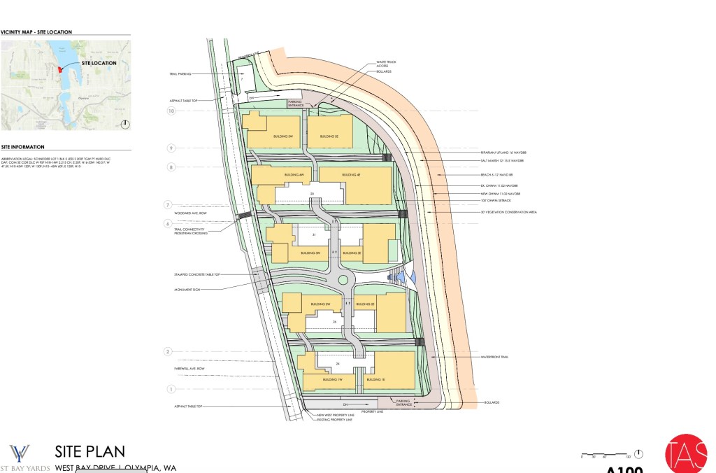
Here we go again. The proposed development at West Bay Yards has been updated and still contains five buildings and 478 units. A SEPA Determination of Non-Significance has been issued. The City’s SEPA Official determined that the anticipated impacts will be addressed by the City’s environmental regulations including the Shoreline Master Program, Critical Area regulations, Drainage Design and Erosion Control Manual, Engineering Design and Development Standards, Municipal Code and the environmental documents submitted with the project application.
Sent to the city:
West Bay Yards Shoreline Permit under review by the City of Olympia. Location at 1201 West Bay Drive. File number 21-2845.
This project would set a precedent. It would be difficult to allow such a development along the waterfront and deny neighbors the same. The most immediate concern would be the proposed West Bayview Landing immediately to the north. Impacts of West Bay Yards could be doubled.
The existing site is built on fill that years ago was placed behind a stone riprap wall about 300 feet out from the previous shore. The plan is to knock back the top few feet of riprap and add 35,000 cubic yards of fill up against what’s left out to the high tide mark. Another 26,515 cubic yards will be added below the high water mark for a total of 61,515 cubic yards of fill, covering over 165,000 square feet of aquatic substrate. This fill would bury whatever is there.
Fill doesn’t come with a ready made benthic community. Species composition evolves over time. Larvae, the swimming babies, swim in and adults move across the seabed, both of which occur slowly over time. Puget Sound’s benthos includes over 1,800 species of invertebrates living in or on the bottom sediments including ghost shrimp, worms, clams, crabs, and sea stars which are consumed by fish, birds, and marine mammals. These species choose specific places according to sediment composition. Soils in river and stream deltas are notoriously soft and muddy.
The delta of Schneider Creek is visible a few hundred feet north of the site in aerial photos. This location has been for thousands of years part or the Deschutes River estuary. The salt wedge is often visible a half mile to the north. If the stream wasn’t run through a pipe, its delta would probably come up to the project line. Companion streams often form an integral part of the structure of a river estuary. This development being part of the river estuary will impact larger options.
A VCA (vegetation conservation area) would extend 30 feet landward from the OHWM. The claim is that the VCA would consist of “native coniferous and deciduous trees and shrubs and would screen the shoreline from the upland uses, while also providing enhanced terrestrial habitat functions.” Runoff and other influences will impact this area of transition. How is such a narrow buffer up next to enormous buildings going to supply all these services?
The proposal states that shoreline restoration and planting will improve foraging habitat for birds. An explanation as to how would be helpful. The plan states that “Shoreline restoration is a major component of this project”. To restore something means to return it to its original condition, place or position. Environmentally this would be the historic baseline. Nothing about this plan is anywhere near the historic baseline.
True beach restoration entails bulkhead removal. It does not involve piling material in front of bulkheads. Narrowing West Budd Inlet might increase velocity of waters flowing from the river and tides flowing in and out which combined with the steeper bank would increase erosion. Added to riverine sediments these will tend to find the lowest spots i.e. the shipping berths and channels.
There may be a “solution”. Use gravel as fill. This would allow the growing of Pacific or Japanese oysters which would otherwise sink in soft mud, a possibility that is being touted as a benefit. These are not native species. They have no place in the ecosystem. The loss of species in Budd Inlet has been well documented. These may be birds who in some cases spend the winters here or are migrating through. It may be salmon and other fish all of whom depend on natural conditions. Or it might affect us. Natural marine ecosystems are productive, resilient and maintenance free.
Not that long ago Budd Inlet was a rich productive ecosystem providing habitat for numerous resident and migratory species, some listed as endangered and some locally extinct. What is the current richness and abundance of species that would be buried? How might this impact other species such as diving ducks? What are the cumulative impacts? Any development of this scale in this location should be based on science.
The City’s Shoreline Master Program states that the City recognizes the importance of restoration of shoreline ecological function and encourages cooperative restoration efforts and programs between local, state, and federal public agencies, tribes, non-profit organizations and landowners…restoration actions should be targeted towards meeting the needs of both sensitive and locally important plant, fish and wildlife species…restoration should be coordinated with other natural resource management efforts and plans… restoration actions should consider system-wide benefits… restoration should give highest priority to measures that have the greatest chance of re-establishing shoreline ecological functions and processes… restoration and enhancement measures should be incorporated into the design and construction of new uses… shoreline restoration and enhancement should be considered as an alternative to structural stabilization… shoreline restoration and enhancement projects should protect the integrity of adjacent natural resources including aquatic habitats and water quality… restoration and enhancement projects should be in keeping with the SMP and restoration and enhancement projects should be designed to minimize maintenance over time.
The plan fails on all counts. There is no recognition of ecological function, no effort to meet the needs of sensitive and locally important plant, fish and wildlife species, no assessment of cumulative impacts or system wide benefits. No effort to re-establish shoreline ecological function or protect the integrity of adjacent natural resources. And this is not a cooperative effort. It’s a matter of coming up with a plan and trying to sell it.
Whatever happens here will set a precedent, the objective being a waterfront surrounded by five story buildings and gravel fill. If scientific inquiry or existing rules play a role, it won’t happen.
The below drawing shows the fill extending around to the north towards the estuary of Schneider Creek and provides some idea of the scale of the proposed construction.
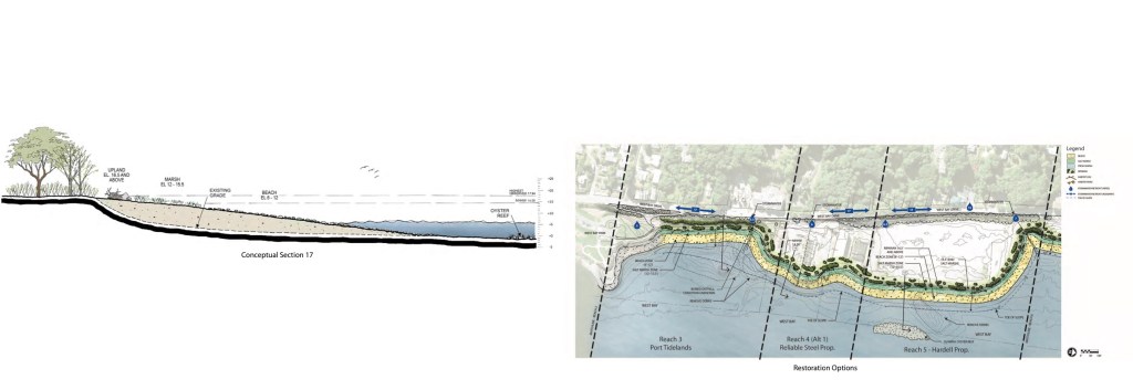
Left below shows the increased steepness of the fill over what currently exists. Neither drawing appears to match the above or other drawings.