There’s a prevailing belief that everything is fine in Budd Inlet. Some of us who’ve been around for a while might not agree. Things have changed dramatically. Ron Secrist was born January 10th 1936. The family lived at the mouth of Schneider Creek. I had the pleasure of interviewing him a decade ago.
On the west side of what is now West Bay drive and on the south side of the Schneider Creek estuary was a home occupied by a gentleman named Demon. The Schneider household was also on the west or inland side of the road. Behind the Schneider household on the hill above to the north was the location of the orchard originally planted in the 1860s by Konrad and Albertina Schneider.
West Bay drive crossed the estuary at its current location. The estuary ran under the road in a culvert that was approximately 40 feet long and four feet in diameter. The bank near the culvert was reinforced with rock riprap. The tide flowed freely through the culvert.
Inland, to the west of the Schneider property was an area of “saw grass”, grass a foot or more tall that would cut you if you walked through it. The area completely flooded at high tide. The grass would lay down at certain times of the year. The estuary extended well up into the valley. The banks heading up the valley were steep, the favorable more level spots being closer to the bay.
On the east side of the road there was a large boathouse and a large over-water warehouse where fruit was packed in sawdust for shipment. There were also a couple of docks and floats and the bank here was armored with a log bulkhead that allowed small ships (coastal freighters about 60 to 70 feet) to pull up to the warehouse. There were several large trees including an ancient cedar and there was a large oyster midden on the north end facing the estuary. Artifacts and evidence of Salish residence including a stone tool that appeared to be for grinding grain and remnants of deer bones were throughout the Schneider property.
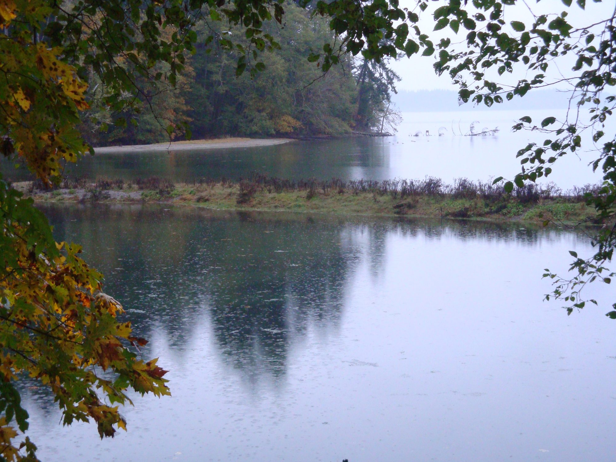
When the stream reached the sound it made an immediate turn to the left or north, past the Schneider property. On the outer, eastern side a long sand spit paralleled the shore heading north. This was sand, not mud. On the shoreward, western side of the estuary the bank was mud but not soft mud. A person could walk on it and it was full of ghost shrimp. (This same feature, an extended sand spit bent by the flow of currents, is today apparent at Tolmie State Park).
Schneider Creek supported a large population of humpys or pink salmon. It probably also supported chum. The variation between years was significant. Some years the stream was “full” of spawning fish.
On one of the family docks Ron could catch 100 shiner perch in an hour fishing with a single hook baited with pieces of pile worms that he gathered by busting up old cedar pilings with a blacksmith’s hammer that he’d found on the site. He says you had to be careful with the worms because their heads could cut you.
There was a cousin who shot a large number of “salt water ducks” (mergansers, scoters, harlequins etc) from a rowboat in an hour or so. As Ron recalls, it was a foggy day and the gunman simply picked them off as they flew past in endless droves. There were often dead ducks on the road by the bridge that had hit power lines in flight. In those days diving ducks were so plentiful they were almost viewed with disdain.
His father had a large rake that he used to rake smelt into a boat in front of the property. He could fill the boat in an hour or so. Surf smelt were very plentiful. Several varieties of clams were also plentiful.
Ron remembers mats of long sinewy stringy grasslike material that he thinks might have been some kind of seaweed or perhaps sea grass but he couldn’t say for sure which. He also remembers lots of what was almost surely sargassum macro algae that had small air pockets that popped when kids stepped on them.
He recalls seeing two inch chambered jellyfish and larger egg shaped jellyfish, lots of bullheads (sculpins) and lots of dogfish.
Heading south in the area of Reliable Steel was where trains would drive out over the bay on a log dock and dump logs into the bay. The logs were rafted up into a series of large booms that virtually filled the southern bay. These booms were towed to various parts north to be processed and shipped. To the north of the Schneider property was Avery’s mill.
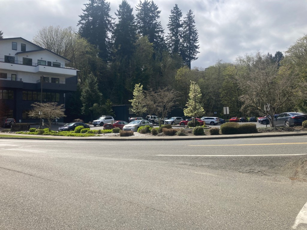
When the Demon property was purchased by the Smyths, they knocked down 100 to 150 feet of high bank and used the soil to fill the Schneider Creek estuary which now runs through a long culvert. The estuary today is a parking lot.
Ron doesn’t recall ever seeing an algae bloom or die off. The estuary had a wonderful smell. When he hears gulls he still gets chocked up thinking of how beautiful Budd Inlet was during his youth.
According to the 1980 East Bay Marina EIS, ghost shrimp and mud shrimp were abundant and widely distributed throughout South Budd Inlet. Perch, flounder, mussels, clams, shore crabs and polychaete worms were all abundant as were many birds.
On December 22, 1979, a census taken by Black Hills Audubon members of East and West Bay totaled 3670 birds. There were 35 species including various grebes, scoters, lunes, mergansers, Barrow’s Goldeneye, Ruddy Duck, Bonaparte’s, Mew and Ring-billed Gulls, American Wigeon, Canvasback, Rhinoceros Auklet, and American Coot. In 1986, 812 waterbirds were counted (21 species). By 2000 the number was down to 168 birds (16 species). Today, it’s few to none.
What’s happened between 1980 and today? The answer is partly low levels of dissolved oxygen due to structural modifications, things like long culverts. There’s no sunlight in a pipe. No sunlight no phytoplankton. No phytoplankton no dissolved oxygen. Two of the principal watersheds in Olympia, Moxlie and Schneider Creek, are led through long culverts. There is also loss of salt marsh, the upper beach and tide flats.
Budd Inlet is in sorry shape. Species are in decline, water quality is in the tank and persistent toxins continue to spread. According to the U.S. Government Accountability Office, “Washington state has failed to meet federal requirements that help prioritize cleanup efforts in Puget Sound to help salmon and steelhead listed as endangered”. (1)
- Low dissolved oxygen and loss of habitat, a double edged sword
Low dissolved oxygen is typically attributed to nutrient loading from septic tanks, fertilizers and other sources. Excessive nutrient loading can lead to algal overgrowth which blocks light that’s needed for plants such as seagrass to grow. When the algae and seagrass die, they decay and dissolved oxygen drops.
Nutrient overloading in one place can also be the result of nutrients no longer being consumed in another place. In a normal stream there’s phytoplankton, tiny plants that consume nutrients and incorporate them into the food web. Olympia sits on 160 miles of culverted surface waters. There’s no sunlight in a pipe. No sunlight no phytoplankton. No phytoplankton no dissolved oxygen.
There’s the hyporheic zone, the area beside and beneath a functional stream where plants, bacteria, fungi and other organisms consume nutrients and feed energy up a web of life.
When freshwater meets saltwater, freshwater being lighter flows out on the surface creating mixing patterns that bring nutrients to the surface where marine organisms consume them and are themselves consumed in a dance of life. All this happens best in shallow water in the presence of abundant sunlight and atmospheric oxygen. Tide flats are one of natures perfect designs.
Physical parameters like shape and structure impact chemical parameters like dissolved oxygen and biological parameters from tiny plankton up to the largest whales. Structural modifications in and around Budd Inlet have led to reduced dissolved oxygen.
- Toxic Pollutants
Benthic sediments, sand and mud on the bottom of the bay, are where contaminants tend to settle. The closer to the surface, the more recent the sediment. Contamination in surface sediments is an indication of uncontrolled sources. Getting surface samples can be a challenge.
Surface benthic contamination in Budd Inlet indicates uncontrolled sources of dioxin. The chemical composition is consistent with wood treatment chemicals. Being mixed with hydrocarbons these chemicals are mobilized, they spread rather than staying put. Dioxin hot spots point to adjoining lands, locations of past human activities. We can determine if these locations are sources of dioxin, if we choose to, by taking and analyzing core samples.
- What’s being done
A City of Olympia Comprehensive Plan update is required every ten years. The deadline to complete this update is June 30, 2025. The plan is to look out to the year 2045.
Olympia’s Shoreline Master Program (SMP) includes policies that “support reasonable private and public uses of the City’s shorelines (within 200’ of lakes, rivers, streams, wetlands, and Budd Inlet) while protecting aquatic wildlife and their habitat.” Most recently updated in 2021, the SMP is required under the State’s Shoreline Management Act. Some regulations from the SMP are included in other sections of Olympia’s Municipal Code, such as the Critical Areas Ordinance. There’s also the Urban Forestry Manual, the Habitat Stewardship Strategy and Olympia’s Storm & Surface Water Utility, whose mission is to “prevent flooding, improve water quality, and protect and enhance aquatic habitat. These particular plans and policies are important to helping the City prepare for sea level rise and other climate-related challenges”.
Climate change and sea level rise are safe subjects for local jurisdictions because any solutions are beyond their purview. If taken seriously we’d see that the perfect machine for breaking down CO2 is plant life including phytoplankton. Phytoplankton produce half the earth’s atmospheric oxygen. When we add other plant life, marine organisms may be responsible for 70% of the earth’s atmospheric oxygen. The choices were clearly explained years ago. The best local response to climate change and sea level rise is to restore nearshore estuarine function. (2)
In 2019 The Port of Olympia published the Port Vision 2050 Action Plan, a “Community Informed Plan for the Future”. What’s meant by community informed? Who were the targets of “targeted outreach” and what was the level of involvement of each? Were these informed decisions? Participation preceded publication. Were these samples random? Use of the word targeted would indicate not. Were all options included? Cleanup and restoration don’t appear to be specifically mentioned anywhere.
The City has the 2045 plan. Once again the word restoration is nowhere be found. When asked about this we’re told it’s included or at least implied under stewardship. Stewardship is the responsible planning and management of resources. A steward is one who manages or looks after another’s property. Restoration is the action of returning something to a former condition. Neither implies the other.
In 2016 The Port of Olympia, in collaboration with the City of Olympia and the Squaxin Tribe released the West Bay Environmental Restoration Assessment, described as a “science-based assessment of environmental restoration opportunities for the West Bay (that) supports the implementation of habitat restoration and water quality strategies… within the project study area, particularly in West Bay Park and the lagoon located south of the developed park”. One problem here is that the mentioned lagoon was set aside as mitigation for dredging East Bay and Federal Agencies would have to be convinced that disruption of a 100 year old benthic community would be an improvement.
The report continues “Twelve restoration alternatives were developed and 18 potential stormwater improvements identified. Taken as a whole, the potential restoration projects provide the opportunity to enhance the ecological functions of West Bay.” Specifics are lacking. How ecological function will be enhanced isn’t clarified and one doesn’t know if any have been carried out.
Planning the cleanup has been turned over to Dalton Olmstead & Fuglevand (DOF) who will handle “engineering and permitting”. DOF provides “engineering solutions and consulting services… including a wide range of approaches from excavation to in-situ remediation methods”. That’s what they do and what they’re recommending here. https://www.dofnw.com/projects
The term “living shoreline” mentioned in the plan could apply to a strip of lawn on top of a pile of rock. Nowhere in this process has any restoration been recognized as a legitimate option. Science should come first. What are the sources and pathways of dioxin and PCBs? Could levels of dissolved oxygen be improved by daylighting streams or allowing salt marsh to recover in places?
Estuaries have been heavily urbanized. Just because people occupy an area doesn’t mean we have to destroy it. The challenge is to incorporate functional restoration into design. What is the relationship between physical, chemical and biological parameters? Can ecological function be improved?
New York City’s Comprehensive Plan, Vision 2020, is an interesting contrast to the current plan for Budd Inlet. The emphasis is entirely on nearshore restoration. (4)
Jurisdictions around San Francisco Bay including the San Francisco Restoration Authority have overseen the restoration of 100,000 acres of tidelands. Any stretch of waterfront that opens up for possible restoration is restored. (5,6,7,8)
- The baseline
On any winter’s day not that long ago we would have seen thousands of birds on Budd Inlet. We would have seen thousands of forage fish and acres of sea grass, macro algae and salt marsh. There were salmon spawning in Schneider, Indian and Percival Creeks and an estuarine environment that served salmon migrating to and from streams and rivers throughout Puget Sound.
Years ago spawning events would have brought masses of sand lance and surf smelt to Budd Inlet’s upper beaches. Herring would have inundated sea grass beds. Once vast in number, these vital species are now locally extinct. We’ve forgotten they ever existed. The current damaged state is our goal. We talk in terms like stewardship, sustainability, mitigation, no-net-loss, … the jargon of the shifting baseline.
“The recognition and concern regarding shifting baselines come from an understanding that many of the world’s resources, including those from the global oceans, are severely depleted because of human activity (Pauly, 1995, 2019), and historical baselines provide more favourable conditions with which to establish management and conservation goals.” (3)
- What could be done
Let’s start with a dream, some time in the future. The dam has been removed and the river is flowing. The Marine Terminal, Percival Landing and the Yacht Club are being scoured by artesian springs and wells with minimal dredging. East Bay has been cleaned up, the upper beach has been restored and the lower half mile of Moxlie Creek has been daylighted. The estuaries of Ellis, Moxlie, Percival and Schneider Creeks have been restored. Where feasible, streams have been removed from culverts.
The idea isn’t to clean up every bit of contamination. The idea is to get rid of major sources and reach a point of equilibrium where Nature can start to heal herself… to have a science based cleanup and restoration and piece our developments into these by mimicking natural features such as overhanging vegetation or a large boulder. In considering any development in a riparian or nearshore area the first consideration should be: Is there anything we can do here to improve ecological function? Restoration is a realistic option. The goal is to reverse the degradation of natural and urban ecosystems. Ecosystem restoration entails changing the human footprint within ecosystems not removing the human footprint.
The State has committed to removing the 5th ave dam and turning Capitol Lake back into an estuary. The Port needs to conduct cleanup and navigation dredging prior to dam removal. The City is concerned about aging infrastructure and sea level rise. It’s like the State, the City and the Port are parties in a dispute. There would be advantages to these three responsible parties working together. Big money likes big multi jurisdictional projects. (9,10,11,12)
Bibliography
(1) “Washington state has failed to meet federal requirements that help prioritize cleanup efforts in Puget Sound to help salmon and steelhead listed as threatened there, according to the Government Accountability Office.”
The southern resident orca population declined from 98 in 1995 to 75 in the latest Center for Whale Research census, and they have been observed to be in poor physical condition and experiencing difficulty raising calves. The Washington state Department of Ecology disagreed with the GAO’s focus in the report on deadlines set for every other year to develop a list of water bodies that do not meet water quality standards…. The audit report lists toxic contaminants, sediment, low levels of dissolved oxygen and warm temperatures as contributing to water quality harmful to salmon in fresh and salt water in the Puget Sound area… Washington state has failed to meet federal requirements that help prioritize cleanup efforts in Puget Sound to help salmon and steelhead listed as threatened there, according to the Government Accountability Office. Poor water quality has played a key role in the decline of salmon populations in the Puget Sound region of Washington state, the report said…”
Read more at: https://www.theolympian.com/news/state/washington/article281669563.html#storylink=cpy
(2) http://www.deschutesestuary.org/wp-content/uploads/2013/10/ThesisDraft12.18.10.pdf
(3) https://link.springer.com/article/10.1007/s10745-023-00398-w
(5) https://www.sfbayrestore.org/
(6) https://savesfbay.org/restore/
(7) https://www.fws.gov/media/san-francisco-bay-shoreline-project-fact-sheetmay-2023pdf
(8) https://www.sfbayrestore.org/announcement/making-progress-towards-100000-acres-restored-tidal-marsh
(10) https://www.epa.gov/nep/nep-coastal-watersheds-award-overview
(11) https://rco.wa.gov/boards/salmon-recovery-funding-board/
